North Lincolnshire
| Borough of North Lincolnshire | |
|---|---|
| Unitary Authority and Borough | |
 | |
| Sovereign state | United Kingdom |
| Constituent country | England |
| Region | Yorkshire and the Humber |
| Ceremonial county | Lincolnshire |
| Admin. HQ | Scunthorpe |
| Government | |
| • Type | North Lincolnshire Council |
| • Leadership: | Leader & Cabinet |
| • Executive: | Conservative |
| • MPs: | Andrew Percy (C) Nic Dakin (L) Martin Vickers (C) |
| Area | |
| • Total | 326.8 sq mi (846.3 km2) |
| Area rank | 41st |
| Population (mid-2017 est.) | |
| • Total | 171,300 |
| • Rank | Ranked 110th |
| • Density | 520/sq mi (200/km2) |
| Time zone | UTC+0 (Greenwich Mean Time) |
| • Summer (DST) | UTC+1 (British Summer Time) |
| ONS code | 00FD (ONS) E06000013 (GSS) |
| Ethnicity | 96.5% White 2.0% S. Asian[1] |
| Website | northlincs.gov.uk |
North Lincolnshire is a unitary authority area in Lincolnshire, England, with a population of 167,446 at the 2011 census.[2] There are three significant towns: Scunthorpe, the administrative centre, Brigg and Barton-upon-Humber.
North Lincolnshire was formed following the abolition of Humberside County Council in 1996, when four unitary authorities replaced it, North Lincolnshire and North East Lincolnshire, on the south bank of the river Humber, and the East Riding of Yorkshire and Kingston upon Hull on the north bank.
It is home to the Haxey Hood, a traditional event which takes place in Haxey on 6 January, a large football scrum where a leather tube (the "hood") is pushed to one of four pubs, where it remains until next year's game.
In 2015, North Lincolnshire Council began discussions with the other nine authorities in the Greater Lincolnshire area as part of a devolution bid. If successful this would see greater powers over education, transport, health, crime and social care being devolved from central government.
Contents
1 Location
2 History of area
3 Towns and villages
4 Politics
5 Economy
6 Education
7 Gallery
8 References
Location
The 846 km2 (327 sq mi) council area lies on the south side of the Humber Estuary and consists mainly of agricultural land, including land on either side of the River Trent. It borders onto North East Lincolnshire, Lincolnshire, South Yorkshire, Nottinghamshire and the East Riding of Yorkshire. The council's administrative base is at the Civic Centre in Scunthorpe.
History of area
Before the creation of Humberside in 1974, it was part of Lincolnshire, becoming North Lincolnshire only in 1996, on the abolition of Humberside. Until 1 April 1996, the area had been part of Humberside. The district was formed by a merger of the boroughs of Glanford and Scunthorpe, and southern Boothferry.
Towns and villages
Alkborough, Althorpe, Amcotts, Appleby, Ashby
Barrow Haven, Barrow upon Humber, Barnetby-Le-Wold, Barton on Humber, Belton, Beltoft, Bonby, Bottesford, Brigg, Broughton, Burringham, Burton upon Stather
Cadney, Coleby, Crowle, Croxton
- Dragonby
Ealand, East Butterwick, East Halton, Eastoft, Elsham, Epworth, Epworth Turbary
Flixborough, Fockerby, Ferriby Sluice
Gainsthorpe, Garthorpe, Goxhill, Grasby, Gunness
Haxey, Hibaldstow, Horkstow, Howsham
Keadby, Kingsforth, Kirmington, Kirton in Lindsey
Manton, Melton Ross, Messingham, Mill Place
New Holland, North Killingholme
- Owston Ferry
Redbourne, Roxby
Sandtoft, Santon, Saxby All Saints, Scawby with Sturton, Scunthorpe, South End, South Killingholme, South Ferriby
- Thornton Curtis
Ulceby, Ulceby Skitter
Walcot, Westwoodside, West Butterwick, West Halton, Whitton, Winteringham, Winterton, Wootton, Worlaby, Wrawby, Wressle
- Yaddlethorpe
Politics
The Labour Party took control of the council, with a majority of 1, from the Conservatives after the 2007 election where the Labour Party had 22 councillors elected. The Conservative Party held 18 seats, the Liberal Democrats held 1 seat and the Independents held two seats.[3] After the 2011 election, the Conservatives regained control of the council with 23 seats, the Labour Party falling to 20 seats.
The area is represented in parliament by three MPs. At the 2010 election the Labour Party retained the Scunthorpe seat and the Conservative Party won the Brigg and Goole seat and the Cleethorpes seat which includes the Barton area.
North Lincolnshire operates under a Cabinet and Leader form of governance. The cabinet has eight members from the largest political party elected to the cabinet by the council of 43.[4] Cabinet members make decisions on their portfolio individually.[5]
Economy
This is a chart of trend of regional gross value added of North and North East Lincolnshire at current basic prices published (pp. 240–253) by Office for National Statistics with figures in millions of British Pounds Sterling. 2004 onwards published (pp. 139) in 2007
| Year | Regional Gross Value Added[6] | Agriculture[7] | Industry[8] | Services[9] |
|---|---|---|---|---|
| 1995 | 3,512 | 82 | 1,701 | 1,729 |
| 2000 | 3,861 | 60 | 1,805 | 1,997 |
| 2003 | 4,569 | 62 | 1,896 | 2,611 |
| 2004 | 4,838 | – | – | – |
| 2005 | 4,941 | – | – | – |
| 2006 | 5,126 | – | – | – |
| 2007 | 5,494 | – | – | – |
Eastern Airways has its head office in the Schiphol House on the grounds of Humberside Airport in Kirmington, North Lincolnshire.[10] Scunthorpe is the home of the Tata owned Appleby-Frodingham steel plant, one of the largest and most successful plants in Europe. Port operations, green energy, logistics, agriculture and food processing are important elements of the areas employment profile.
Education
Gallery
.mw-parser-output .mod-gallery{display:table}.mw-parser-output .mod-gallery-default{background:transparent;margin-top:0.5em}.mw-parser-output .mod-gallery-center{margin-left:auto;margin-right:auto}.mw-parser-output .mod-gallery-left{float:left}.mw-parser-output .mod-gallery-right{float:right}.mw-parser-output .mod-gallery-none{float:none}.mw-parser-output .mod-gallery-collapsible{width:100%}.mw-parser-output .mod-gallery .title{display:table-row}.mw-parser-output .mod-gallery .title>div{display:table-cell;text-align:center;font-weight:bold}.mw-parser-output .mod-gallery .main{display:table-row}.mw-parser-output .mod-gallery .main>div{display:table-cell}.mw-parser-output .mod-gallery .caption{display:table-row;vertical-align:top}.mw-parser-output .mod-gallery .caption>div{display:table-cell;display:block;font-size:94%;padding:0}.mw-parser-output .mod-gallery .footer{display:table-row}.mw-parser-output .mod-gallery .footer>div{display:table-cell;text-align:right;font-size:80%;line-height:1em}.mw-parser-output .mod-gallery .gallerybox .thumb img{background:none}.mw-parser-output .mod-gallery .bordered-images img{border:solid #eee 1px}

St. Hybald Church in Hibaldstow, Brigg

Mount Pleasant Mill in Kirton in Lindsey

Thornton Abbey in Thornton Curtis
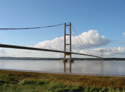
Humber Bridge between Hessle and Barton-upon-Humber


References
^ Office for National Statistics
^ UK Census (2011). "Local Area Report – North Lincolnshire Local Authority (1946157111)". Nomis. Office for National Statistics. Retrieved 2 March 2018..mw-parser-output cite.citation{font-style:inherit}.mw-parser-output q{quotes:"""""""'""'"}.mw-parser-output code.cs1-code{color:inherit;background:inherit;border:inherit;padding:inherit}.mw-parser-output .cs1-lock-free a{background:url("//upload.wikimedia.org/wikipedia/commons/thumb/6/65/Lock-green.svg/9px-Lock-green.svg.png")no-repeat;background-position:right .1em center}.mw-parser-output .cs1-lock-limited a,.mw-parser-output .cs1-lock-registration a{background:url("//upload.wikimedia.org/wikipedia/commons/thumb/d/d6/Lock-gray-alt-2.svg/9px-Lock-gray-alt-2.svg.png")no-repeat;background-position:right .1em center}.mw-parser-output .cs1-lock-subscription a{background:url("//upload.wikimedia.org/wikipedia/commons/thumb/a/aa/Lock-red-alt-2.svg/9px-Lock-red-alt-2.svg.png")no-repeat;background-position:right .1em center}.mw-parser-output .cs1-subscription,.mw-parser-output .cs1-registration{color:#555}.mw-parser-output .cs1-subscription span,.mw-parser-output .cs1-registration span{border-bottom:1px dotted;cursor:help}.mw-parser-output .cs1-hidden-error{display:none;font-size:100%}.mw-parser-output .cs1-visible-error{font-size:100%}.mw-parser-output .cs1-subscription,.mw-parser-output .cs1-registration,.mw-parser-output .cs1-format{font-size:95%}.mw-parser-output .cs1-kern-left,.mw-parser-output .cs1-kern-wl-left{padding-left:0.2em}.mw-parser-output .cs1-kern-right,.mw-parser-output .cs1-kern-wl-right{padding-right:0.2em}
^ "North Lincolnshire Council election results for 2007". North Lincolnshire Council. Archived from the original on 26 May 2009. Retrieved 27 July 2011.
^ "Cabinet". North Lincolnshire Council. Archived from the original on 27 March 2010. Retrieved 10 May 2010.
^ "Decision Making By Cabinet Members". North Lincolnshire Council. Archived from the original on 28 February 2009. Retrieved 10 May 2010.
^ Components may not sum to totals due to rounding
^ includes hunting and forestry
^ includes energy and construction
^ includes financial intermediation services indirectly measured
^ "Contact Us]". Eastern Airways. Archived from the original on 16 December 2009. Retrieved 2 May 2010.
Districts of Yorkshire and the Humber | ||
|---|---|---|
| Lincolnshire |
|  |
| North Yorkshire |
| |
| South Yorkshire |
| |
| West Yorkshire |
| |
| East Riding of Yorkshire |
| |
England Portal | |
| Unitary authorities |
|
| Boroughs or districts |
|
| Major settlements |
|
| Topics |
|
| Districts |
|  |
|---|---|---|
| Councils |
| |
| Local elections |
| |
Coordinates: 53°36′N 0°39′W / 53.60°N 0.65°W / 53.60; -0.65


