A roads in Zone 1 of the Great Britain numbering scheme

Roundabout on the A189 spine road between Woodhorn and Ellington near to Linton
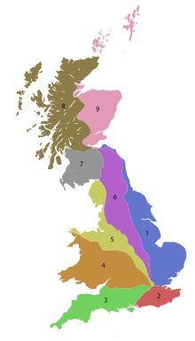
The numbering zones for A-roads in Great Britain
List of A roads in zone 1 in Great Britain beginning north of the Thames, east of the A1 (roads beginning with 1).
Contents
1 Single- and double-digit roads
2 Triple-digit roads
3 Four-digit roads (10xx)
4 Four-digit roads (11xx)
5 Four-digit roads (12xx and higher)
6 References
7 External links
Single- and double-digit roads
| Road | From | To | Notes | |
|---|---|---|---|---|
Central London (St Paul's Cathedral) | Edinburgh | Often called the "Great North Road". London sections of road covered by separate A1 road (London) article | ||
Central London (The Monument) | King's Lynn | Section round Cambridge overlaps M11 and A14 | ||
Central London (Aldgate) | Norwich | Section between Bow and Stump Cross (M11 J9) superseded by A12 and M11. Section round Newmarket overlaps A14 | ||
Central London (Blackwall) | Lowestoft | Section round Ipswich overlaps A14. Section between Lowestoft and Great Yarmouth redesignated as A47 in 2017 | ||
Central London (Aldgate) | Shoeburyness | |||
M6 motorway | Felixstowe Port | Originally the A14 was the Old North Road, which forms part of the Roman Road known as Ermine Street. It ran from Royston in Hertfordshire through Huntingdon to meet with the A1 south of Alconbury. The Royston-Huntingdon section is now the A1198; the section north of Huntingdon is a spur of the A14 although no number appears on signs. | ||
Norman Cross near Peterborough | Hessle | |||
Grimsby | Peterborough* | New stretch between Spalding and Peterborough now open, the previous road from Spalding to Stamford becoming the A1175. | ||
Newark-on-Trent | King's Lynn | |||
Doncaster | Ludborough | |||
Doncaster | Seaton Burn |
Triple-digit roads
| Road | From | To | Notes |
|---|---|---|---|
Bricklayers' Arms, South London | Tower Hill, City of London | Part of the London Inner Ring Road | |
Limehouse | Rotherhithe | Rotherhithe Tunnel | |
Charlton | Clapton | Includes the Blackwall Tunnel and former A102(M) motorway south of the tunnel. Section between A13 and Hackney Wick redesignated as A12. | |
Highbury | Hornsey | The northern end of this road is called Tottenham Lane but actually it is Arsenal whose stadium it will go past at the other end. | |
Islington Green | Epping | The northern section of this road, beyond Woodford Green, was originally A11 | |
Canonbury | Enfield Town | Formerly continued north to A1010 south of Waltham Cross | |
Hackney | Wanstead | Formerly ended at Leytonstone, but according to some maps seems to have taken over bits of the old A11 and A12. Originally, the number referred to the A12 Eastern Avenue section. | |
Whitechapel | Manor House | via Hackney and Clapton | |
| Unused | Was allocated twice. Firstly on what's now the A1080 and A10, from the A105 junction at Wood Green to the A1170 junction at Waltham Cross. Secondly, it was used for what's now the A19 from Seaham to Seaton Burn (at the time, the A19 went on the current A1018). It is sometimes an error for the A1083. | ||
Whetstone | Tottenham | Western-most side off A1000 as Oakleigh Road North, becomes Oakleigh Road South, then re-appears off A1003 Friern Barnet Road as Station Road, across the A406 into Bounds Green Road. To the East of A105 Green Lanes as Lordship Lane crossing the A1080 and the A10 until it hits A1010 Tottenham High Road. | |
Woodford Green | Barnet | ||
Palmers Green | Potters Bar | ||
Waltham Abbey | Woolwich Ferry | ||
Leytonstone | Chipping Ongar | ||
Plaistow | Whipps Cross | ||
| Unused | Ran from Hackney Wick to Stratford. Eliminated in 2010; now Chapman Road, Rothbury Road, White Post Lane, and Carpenters Road. The original alignment went from Leytonstone to Valentines, which is now mostly part of the A12, which was rerouted along similar roads. | ||
Manor Park | Wanstead | ||
Aldersbrook | Woolwich Ferry | ||
Bow | Romford | Section between Bow and Stratford was A11, with the section east of Stratford forming the original A12. An older one went from Canning Town to Rippleside. This is now part of the A13 (which the old route became an extension of the A124 and A123) | |
Ware | Watton-at-Stone | See also A602 | |
Puckeridge | Harwich | ||
Waltham Cross | Woodford Green | ||
| Unused | Ran from Epping to Chelmsford. Rerouted to Hastingwood later. Renumbered as part of the A414 (old route now B183 and A1060). | ||
Chigwell | Barking | East of Barking town centre (Ripple Road) was the original A13. A13 still uses much of the original (albeit dualled) Ripple Road towards Dagenham. | |
Canning Town | Upminster | Western section was the original A13 as far as Barking. | |
Romford | Rainham | ||
West Thurrock | Tilbury | seems to have two western termini, on the A13 and A1090 | |
Romford | Southend | Known as the Southend Arterial Road | |
Orsett | Chipping Ongar | used to run from Tilbury | |
Shenfield | Hadleigh | ||
Little Waltham | Canvey Island | Used to start at Trumpington, near Cambridge. Originally ended on the A129 near Rayleigh until extended to the A127 and then Canvey Island.In 2008 from Dunmow to Chelmsford the road was downgraded to B1008. | |
| Little Waltham | Sudbury | ||
Basildon | South Woodham Ferrers | Originally allocated to the road from Colchester to Huntingdon (now A1124, A1017, A143, A1307, A14 (former A604)). | |
Colchester | Clacton-on-Sea | by way of Elmstead Market, Frating, Great Bentley and Weeley. | |
King's Lynn | Colchester | ||
Stockton-on-Tees | Egglescliffe | Originally this number belonged to the road from Colchester to Harwich via Manningtree in Essex; this is now shared between the A137 and, east of Manningtree B1352. Traffic from Colchester to Harwich is now directed via the A120. | |
Harwich | Harwich International Port | Originally this ran from Harwich to Clacton. More recently it ran from a junction with the A120 near Parkeston Quay, west of Harwich, to Harwich town, where there is another international port. Today it runs from the same junction to Parkeston Quay. | |
Ipswich | Colchester | ||
Chelmsford | The Chelmsford ring road. Previously allocated to a road between Ipswich and Shotley Gate (now B1456). | ||
Stockton-on-Tees | Billingham | Previously allocated to a road between Ipswich and Felixstowe (now old A14). | |
Needham Market | Cromer | ||
Guyhirn | Huntingdon | ||
Chatteris | Newmarket | ||
Great Yarmouth | Haverhill | ||
Darsham | Bungay | Originally continued to Norwich, the Bungay-Norwich section since renumbered B1332 | |
Blythburgh | Beccles | ||
Norwich | Lowestoft | ||
Norwich | Norwich | Part of the Norwich inner ring road; previously allocated to a road between Norwich and Cromer (now A140). | |
King's Lynn | Cromer | Cromer-Mundesley section of B1159 (since reclassified to a C road) was previously part of A148 | |
Great Yarmouth | Kings Lynn | ||
| Unused | Previously allocated to a road between Wisbech and Long Sutton. It is now the A1101.[1] | ||
Colsterworth | Holbeach | ||
Donington | Surfleet | ||
Honington | Louth | ||
Felixstowe | Felixstowe | The original alignment went from Mablethorpe to Donington (now A52). | |
Tumby | West Keal | ||
Saxilby | Gainsborough | ||
Wragby | Maltby le Marsh | ||
Lincoln | Skegness | ||
Scunthorpe | Gainsborough | ||
Ulceby, North Lincolnshire | Immingham | Previously allocated to a road between Croxton and Barrow upon Humber (now B1211). | |
Beckingham | Goole | ||
Ferrybridge | Tadcaster | ||
Selby | Holme on Spalding Moor | ||
Hessle | Driffield | ||
Kingston upon Hull | Scarborough | ||
York | Bridlington | ||
Topcliffe | Kenton Bar | In County Durham this road largely follows the old course of the A1. | |
Boston Spa | Northallerton | ||
Malton | Whitby | ||
Thirsk | Scarborough | ||
Middlesbrough | Scarborough | ||
Tontine | Middlesbrough | ||
Stokesley | Skelton-in-Cleveland | ||
Thornaby-On-Tees | Whitby | ||
A175 road | Unused | Previously a road between South Bank and Normanby. | |
| Vange, near Basildon | Billericay | Previously allocated to a road between Thornaby-On-Tees and Middlesbrough (now old A66). | |
Stockton | Durham | ||
Middlesbrough | Hartlepool | ||
A19 | Hartlepool | ||
Barnetby-le-Wold | Cleethorpes | Previously allocated to a road between Durham and Byers Garth (now B1198); originally proposed on what is now the A1086. | |
Durham | Castle Eden | ||
A194(M) | Easington Village | ||
Chester-le-Street | South Shields | ||
Sunderland | Gateshead | ||
Felling | South Shields | ||
Newcastle upon Tyne | North Shields | ||
Heaton | North Shields | ||
Heaton | Forest Hall | ||
Newcastle upon Tyne | Ashington | ||
| Dudley bypass, North Tyneside | Seaton Sluice | Known locally as The Avenue | |
Kenton Bar | Whitley Bay | ||
North Shields | Morpeth | ||
Bedlington | Byker | ||
Washington | South Shields | Previously allocated to a road between Seaton Burn and Blyth (now A1068, A192, B1505 (FORMER A189), A193, B1329 (former A193)). | |
Washington | Wardley | Previously allocated to a road between Morpeth and Plessey Checks (now A192). | |
Morpeth | Ashington | ||
Clifton, Northumberland | Newbiggin-by-the-Sea | ||
| Tyninghame | Tranent | ||
Leith | West Barns |
Four-digit roads (10xx)
| Road | From | To | Notes |
|---|---|---|---|
Highgate | Welwyn | ||
| Near Hatfield | Hatfield | ||
Southgate | North Finchley | ||
Southgate | Palmers Green | ||
Potters Bar | Enfield | ||
Leyton | Walthamstow | ||
Snaresbrook | Wanstead | ||
| South Chingford | Woodford | ||
Tottenham | Waltham Cross | Former A10 alignment; an older A1010 went from Canning Town to North Woolwich (now A1011, Victoria Dock Road, and A112). | |
West Ham | Silvertown | significant portion is now A1020 | |
North Stifford | Grays | ||
Stanford-le-Hope | Grays | Former A13 alignment (pre-1980s) between Stanford and Lodge Lane, Grays. Section between Lodge Lane and Grays town centre possibly the original A13 alignment. Lodge Lane between A1013 and A1306 is presently unclassified but was also part of the A13 till the 1980s. | |
Stanford-le-Hope | Coryton Refinery | ||
Rayleigh | Eastwood | ||
| North Shoeburyness | Shoeburyness | ||
Haverhill | Gosfield | ||
South Shields | A19 near Seaham | Former A19 alignment; a former alignment went along the old A1 through Grantham (now B1174), and the original alignment went from A137 west of Manningtree to Mistley (became A604 spur, now A1352). | |
Harlow | Harlow | ||
East India Docks | Beckton | ||
Felixstowe | Felixstowe | ||
Ipswich | Ipswich | ||
| Brook Street (Brentwood) | Mountnessing | Former A12 alignment; an earlier A1023 went from A47 to A134 in Crimplesham (now unclassified). | |
Norwich | Old Catton | ||
Harlow | Harlow | ||
Hartburn | Billingham | ||
Ulceby Cross | Candlesby | ||
Scunthorpe | Scunthrope | ||
Cleethorpes | Mablethorpe | ||
Hemlington | Portrack | ||
Kingston upon Hull | Withernsea | ||
A63 at South Cave | A1079 at Market Weighton | ||
B1242 at Hornsea | A1079 near Beverley | Formerly started at A165 at Leven but extended when B1244 was reclassified as A1035 in 2013. | |
Copmanthorpe | Huntington | Former A64 through York prior to the York By Pass | |
Chingford | Chingford | Waltham Way, runs alongside the River Lee Diversion and William Girling Reservoir | |
Bridlington | Bridlington | ||
Staxton | Filey | ||
A614 | Selby | ||
| Duplicated, one in Redcar, one in Norwich | Norwich version post-dates Redcar, part of the Norwich outer ring road, previously A47 and B1454. See Anomalously numbered roads in Great Britain | ||
A1043 road | Nunthorpe | Nunthorpe | Nunthorpe Bypass |
Yarm | Hemlington | Originally went northeast along what is now the B1380 between what was previously the A1045 to the A174. | |
A1045 road | Unused | Ran from Thornaby-on-Tees to Stockton-on-Tees (now A1044 and Thornaby Road; the A1044 went northeast on what is now the B1380) | |
Stockton-on-Tees | Port Clarence | ||
Hartlepool | Hartlepool | ||
Hartlepool | Hartlepool | ||
| A1050 | Unused | Ran from Farewell Hall to Durham (now A177/South Road and Church Street) | |
| A1051 | Unused | Ran from A177/Hallgarth Street to Crossgate (now A177, Quarryheads Lane, and Margery Lane) | |
Houghton Gate | Houghton-le-Spring | ||
Lazenby | Grangetown | ||
Norwich | Norwich | ||
Tottenham Hale | Waltham Cross | ||
North Brunton | Killingworth | ||
Hazlerigg | Backworth | ||
Hatfield | St Albans | ||
Newcastle upon Tyne | Tynemouth | ||
| A1059 | Unused | Ran from London Road (this was then A1184, but now B1383) to A1250 in Bishop's Stortford (now North Street, Poter Street, and South Street, possibly B1529). | |
Bishop's Stortford | Sandon | ||
| Shankhouse | South Beach, Blyth | ||
Hoveton | Potter Heigham | Previously an eastward continuation of the B1354; the original A1062 went from Bebside to Beddingtion (now A193) | |
Acle | Near Caister-on-Sea | ||
Mildenhall | Fakenham | ||
Thetford | Diss | ||
Norwich | Fakenham | significant portion is now B1454 between Tattersett and Heacham via Docking | |
Seaton Burn | Alnwick | ||
Chingford | Buckhurst Hill | ||
Stevenage | |||
Newton, Suffolk | Ipswich | ||
Stevenage | Stevenage | ||
| Unused | Ran from Eye to Spalding. Now downgraded to two C-roads, after opening of the new A16 road. The current road will remain open, but declassified, as a local road. | ||
New Costessey | Norwich | Previously part of the A47 prior to the construction of the Norwich southern bypass; formerly used on the Norwich Ring Road. | |
Thetford | East Dereham | ||
Gaywood | Kings Lynn | ||
Scunthorpe | South Killingholme | ||
Kings Lynn | South Wootton | ||
York | Kingston upon Hull | ||
Turnpike Lane Underground station | Tottenham | Formerly numbered as part of the A108; the original route went from the A11 (now Broadway) to the A12 (now Broadway) in Stratford (now A118/The Grove). | |
Luton | High Barnet | Previously allocated to present A1400 and A406 from Gants Hill to Walthamstow Forest. This road was originally the A6. Its actual numbering is curious because it is out of zone. | |
A148 | A149 at Sheringham | Previously numbered as the B1158; original location was on what is now the western half of the Whipps Cross Roundabout | |
Becontree Heath | Ilford | ||
Brigg | Caistor | ||
Middlesbrough | A174 south of Marske-by-the-Sea | ||
Easington | Hartlepool | ||
Beltonford | Broxburn | ||
Woolpit | Thetford | ||
Orsett Heath | Tilbury Cruise Terminal | this is the Trunk Road into Tilbury (and not the A13!) | |
Purfleet | West Thurrock | ||
Baythorne End | Long Melford | ||
A12 near Stratford St. Andrew | Aldeburgh | ||
A12 near Blythburgh | Southwold | ||
Galley Hill | St Ives | ||
| Westgate/B1200 (was A157) Louth | Grimsby Road/B1502 (was A16) in Louth | Before the Louth bypass was opened in 1991, it directed traffic heading between the west and the north away from the town centre along St Mary's Lane. Designation downgraded at that time to part of B1200 | |
New Waltham | Cleethorpes | ||
Chelmsford | Chelmsford |
Four-digit roads (11xx)
| Road | From | To | Notes |
|---|---|---|---|
| A1100 | Unused | Ran from Copdock to Great Blakenham (now B1113, Swan HIll, and The Street). | |
Bury St. Edmunds | Littleport | ||
West Rasen | Osgodby Moor | ||
Ulceby Cross | Mablethorpe | ||
Kingston upon Hull | Near Hessle | ||
Cockburnspath | Near Burnmouth | ||
Chirton | Billy Mill | ||
New Southgate | A406 | The western section of Bowes Road that passes through Arnos Grove. | |
Alford | Sutton-on-Sea | Subject of the song 'the A1111' by John Shuttleworth, the stage persona of Graham Fellows | |
Abridge | Dagenham | Southern section used to follow what is now A1240, and formerly, north of the A12 it was B196 as far as Hainault Forest and north of there part of a much longer B174, while south of the A124 it was part of a much longer B178. | |
| A1113 | Unused | Ran from A1099 to A138 in Chelmsford (now B1137). | |
| Duplicated, one in Gateshead, one in Chelmsford | See Anomalously numbered roads in Great Britain | ||
| A1115 | Unused | Ran from Winceby to Scremby (now B1195, Ashby Road, and Northfield Road). | |
Carlton Colville | Corton | ||
| A1118 | Unused | Was a loop around the A12 in Lowestoft (became one way; now B1532). | |
Combs Ford | Yoxford | ||
Boston | Swineshead Bridge | ||
Outwell | Swaffham | ||
Huntingdon | Soham | ||
Sible Hedingham | Colchester | ||
Fletton | Woodston, Cambridgeshire | ||
Stockton-on-Tees | Acklam | ||
Winthorpe | Torksey | ||
Cambridge | Cambridge | Also the Cambridge Ring Road | |
Healing | Grimsby | ||
Boston | Boston | ||
Eye | Orton, Peterborough | Doubles as Fletton Parkway, part of Peterborough's Parkway system and a major part of the city's road network. | |
Edinburgh | Edinburgh | This road runs from the A1 at Piershill to A199 at Portobello. The whole length of the road is called Portobello Road. | |
Hoggard's Green | Hadleigh | ||
Oulton | Lowestoft | ||
Carlton Colville | Lowestoft | ||
Hatfield | Thorne | ||
Bedlington | Stakeford | ||
Monkseaton | Whitley Bay | ||
North Shields | Chirton | ||
Harrowgate Village | Great Burdon | ||
A147 Norwich | A149 near Stalham | Passes through Wroxham, the 'capital' of the Norfolk Broads | |
A12 North of Woodbridge | Rendlesham | ||
Barking | Becontree | ||
Stevenage | Stevenage | ||
Ipswich | Ipswich | Former A45 | |
Westcliff-on-Sea | Prittlewell | ||
Southend on Sea | Southend Airport | ||
Southend on Sea | Seafront | Short link road from A13 | |
A63 in Kingston upon Hull | A1079 in Kingston upon Hull | ||
Anlaby Park | Kingston upon Hull | ||
Berwick | Scremerston | ||
Chigwell Rolls Park | Loughton Homebase | Formerly B171 | |
Harlow | Harlow | ||
Ware | Turnford | ||
Annitsford | Cramlington | ||
Cramlington | Cramlington | ||
Caistor | Immingham | ||
Kingston upon Hull | Beverley | This road includes the notorious Grovehill junction, which has 42 traffic lights. | |
Spalding | Stamford | Previous route of A16 road between Spalding and Stamford, before completion of the A1073 upgrade. | |
| Unused | Temporary designation for what is now the M25 between junctions 23 (South Mimms) and 24 (Potters Bar). Would have been part of the planned M16 (Ringway 3). | ||
Peterborough | Longthorpe | ||
Bishops Stortford | Harlow | Most of this formed the old A11 route between the two towns | |
Wolviston | Seal Sands | ||
Rushmere St. Andrew | Nacton Heath | ||
Royston | Godmanchester | Original route of the A14 | |
| Duplicated, one in Islington, London, and one in Woodford, London | See Anomalously numbered roads in Great Britain |
Four-digit roads (12xx and higher)
| Road | From | To | Notes | |
|---|---|---|---|---|
Moorfields Eye Hospital | Highbury & Islington station | |||
Canonbury | Alexandra Palace | |||
Central London (Aldgate) | Central London (Shoreditch | Part of the London Inner Ring Road | ||
Tower Hill | Poplar | Includes the Limehouse Link tunnel in Docklands. Number seems also to refer to Butcher Row, a spur that connects to the A13 at Limehouse | ||
South Hackney | Limehouse | Burdett Road and Grove Road, crosses A11 at Mile End station. | ||
Limehouse | Blackwall | This is a crescent-shaped round around the Isle of Dogs. If you actually want to go from Limehouse to Blackwall you would use the A1261 | ||
Hackney | Dalston | Graham Road with Western boundary at Queensbridge Road where the A104 temporarily heads northbound. | ||
Hoxton | Cambridge Heath | Hackney Road. | ||
Shoreditch | Bethnal Green | Bethnal Green Road | ||
| A1210 | Tower Hill | Aldgate | One-way section of the London Inner Ring Road, mostly Mansell Street, with links via Minories and Goodman's Yard | |
Barbican | Aldgate | |||
Ipswich | Martlesham | Former route of A12, prior to Ipswich Southern/Eastern by-pass | ||
Washington | Central Sunderland | |||
Colchester | A12/A120 | Former A12 alignment through northern Colchester. See also A120 | ||
Basildon | Basildon | Cranes Farm Road, parallels the A127 and the A1321 between the A176 and A132 roads | ||
Copmanthorpe | A64 | York Outer Ring Road (Western & Northern) | ||
Thorpe Willoughby | Barlby | |||
Becontree | Dagenham | Formerly numbered A1112 | ||
Norwich | Thorpe St Andrew | Previously part of the A47 prior to the construction of the Norwich southern bypass. | ||
Great Yarmouth | Great Yarmouth | Shares the same number with Scartho Road and a stretch of Louth Road to the south of Grimsby. See Anomalously numbered roads in Great Britain | ||
Benfleet | Howe Green | Previously the A130 | ||
| Selby Fork | Brotherton | Previously part of the A1 | ||
Bishops Stortford | Bishops Stortford | |||
Romford | Romford | |||
Peterborough | Peterborough | |||
Limehouse | Leamouth | Aspen Way, East India Dock Link tunnel, and West India Dock Road in Docklands | ||
| A1270 | Taverham | Rackheath | Norwich Northern Distributor Road | |
Sunderland | Monkwearmouth | |||
Jarrow | South Shields | John Reid Road, South Shields southern ring road | ||
Trumpington | Stump Cross | The original A1301 went from Sadlers Farm to Canvey Island. This became part of the A130 and B1014 (the old B1014 became part of the A130), and the current A1301 was designated on the old route of the A130. | ||
Westley | Southgate Bridge | |||
Hardwick | Newmarket | Former A45 | ||
Six Mile Bottom | Water Hall | Former A11 | ||
Stockton-on-Tees | Stockton-on-Tees | |||
Dagenham | North Stifford | Former A13 alignment, with unclassified Lodge Lane connecting to the A1013. Eastern section was the main route till the 1980s. Western section was the main route until as recently as the late 1990s. | ||
Girton | Haverhill | Formerly A604 and before that A132 | ||
Stowmarket | Combs Ford | |||
Trumpington, Cambridgeshire | Milton, Cambridgeshire | Former A10 alignment | ||
| South Hornchurch | South Hornchurch | Marsh Way, link road between A13 and A1306. Briefly part of A13 during completion of Thames Gateway 1998-9. | ||
Basildon | Basildon | Broadmayne, parallels the A1235 between the A176 and A132 roads | ||
Stowmarket | Combs Ford | |||
North Circular Charlie Brown's Roundabout | Gants Hill | Formerly A406, but this section was only briefly considered part of the North Circular, the latter historically using the A104/A114/A116/A117 until 1987. | ||
Haddenham | Witcham | |||
Lincoln | South Hykeham | |||
Scampton | Marton | Forms the eastern section of the Roman road from Ermine Street to Bawtry, fording the River Trent at Littleborough (the Roman settlement of Segelocum), then onto the Roman Fort at Doncaster (Danum). |
References
^ "A150". Society for All British and Irish Road Enthusiasts. 13 May 2010. Archived from the original on 8 August 2010. Retrieved 29 June 2010..mw-parser-output cite.citation{font-style:inherit}.mw-parser-output q{quotes:"""""""'""'"}.mw-parser-output code.cs1-code{color:inherit;background:inherit;border:inherit;padding:inherit}.mw-parser-output .cs1-lock-free a{background:url("//upload.wikimedia.org/wikipedia/commons/thumb/6/65/Lock-green.svg/9px-Lock-green.svg.png")no-repeat;background-position:right .1em center}.mw-parser-output .cs1-lock-limited a,.mw-parser-output .cs1-lock-registration a{background:url("//upload.wikimedia.org/wikipedia/commons/thumb/d/d6/Lock-gray-alt-2.svg/9px-Lock-gray-alt-2.svg.png")no-repeat;background-position:right .1em center}.mw-parser-output .cs1-lock-subscription a{background:url("//upload.wikimedia.org/wikipedia/commons/thumb/a/aa/Lock-red-alt-2.svg/9px-Lock-red-alt-2.svg.png")no-repeat;background-position:right .1em center}.mw-parser-output .cs1-subscription,.mw-parser-output .cs1-registration{color:#555}.mw-parser-output .cs1-subscription span,.mw-parser-output .cs1-registration span{border-bottom:1px dotted;cursor:help}.mw-parser-output .cs1-hidden-error{display:none;font-size:100%}.mw-parser-output .cs1-visible-error{font-size:100%}.mw-parser-output .cs1-subscription,.mw-parser-output .cs1-registration,.mw-parser-output .cs1-format{font-size:95%}.mw-parser-output .cs1-kern-left,.mw-parser-output .cs1-kern-wl-left{padding-left:0.2em}.mw-parser-output .cs1-kern-right,.mw-parser-output .cs1-kern-wl-right{padding-right:0.2em}
| Wikimedia Commons has media related to A roads in the United Kingdom. |
External links
| Wikimedia Commons has media related to A roads in Zone 1 of the Great Britain numbering scheme. |


