Dundalk
Dundalk Dún Dealgan | ||
|---|---|---|
Town | ||
 Clockwise from top: Castle Roche, Clarke Station, St. Patrick's Pro-Cathedral, The Marshes Shopping Centre, Market Square, Dundalk Institute of Technology | ||
| ||
Motto(s): Mé do rug Cú Chulainn cróga (Irish) "I gave birth to brave Cú Chulainn" | ||
 Dundalk Location in Ireland Show map of Ireland  Dundalk Dundalk (Europe) Show map of Europe | ||
Coordinates: 54°00′32″N 6°24′18″W / 54.009°N 6.4049°W / 54.009; -6.4049Coordinates: 54°00′32″N 6°24′18″W / 54.009°N 6.4049°W / 54.009; -6.4049 | ||
| Country | Ireland | |
| Province | Leinster | |
| County | County Louth | |
| Dáil Éireann | Louth | |
| EU Parliament | Midlands–North-West | |
| Inhabited | 3500 BC[1][2][3] | |
| Charter | 1189 | |
| Area[4] | ||
| • Urban | 25.19 km2 (9.73 sq mi) | |
| • Rural | 354.04 km2 (136.70 sq mi) | |
| Population (Census 2016) | ||
| • Rank | 8th | |
| • Urban | 39,004 [5] | |
| Time zone | UTC±0 (WET) | |
| • Summer (DST) | UTC+1 (IST) | |
Eircode routing key | A91 | |
| Telephone area code | +353(0)42 | |
| Irish Grid Reference | J048074 | |
| Website | www.dundalk.ie | |

Dundalk (/dʌnˈdɔːk/, Irish: Dún Dealgan, meaning "Dalgan's fort")[6] is the county town of County Louth, Ireland. It is on the Castletown River, which flows into Dundalk Bay, and is near the border with Northern Ireland, halfway between Dublin and Belfast. It has associations with the mythical warrior hero Cú Chulainn.[citation needed]

Map of Dundalk
Contents
1 History
1.1 Battles
1.2 Coat of arms
2 Geography
2.1 Landscape
2.2 Climate
3 Demographics
4 Places of interest
5 Arts and festivals
6 Transport
7 Education
7.1 Primary schools
7.1.1 Irish-medium
7.1.2 English-medium
7.2 Secondary schools
7.2.1 Irish-medium
7.2.2 English-medium
7.3 Tertiary education
8 Media
9 Sport
9.1 Association football
9.2 Rugby
9.3 Ice hockey
9.4 Horse racing and greyhound racing
9.5 Fencing
9.6 Basketball
9.7 American football
9.8 Tennis
9.9 Cricket
9.10 Snooker
9.11 Cycling
9.12 Kayaking
9.13 Gaelic Football
10 Politics and government
11 Notable people
11.1 Arts and Media
11.2 Academia and Science
11.3 Politics
11.4 Religion
11.5 Sport
11.6 Military
11.7 Business
12 Twinning / sister cities
13 Namesakes
14 See also
15 References
16 External links
History

St. Patrick's Church, Dundalk
The Dundalk area has been inhabited since at least 3500 BC, in the Neolithic period. A tangible reminder of this early presence can still be seen in the form of the Proleek Dolmen, the eroded remains of a megalithic tomb located in the Ballymascanlon area to the north of Dundalk. Celtic culture arrived in Ireland around 500 BC. According to the legendary historical accounts,[7] the group settled in North Louth were known as the Conaille Muirtheimne and took their name from Conaill Carnagh, legendary chief of the Red Branch Knights of Ulster. Their land now forms upper and lower Dundalk.
Dundalk had been originally developed as an unwalled Sráid Bhaile (meaning village; translates literally as "Street Townland"). The streets passed along a gravel ridge which runs from the present day Bridge Street in the North, through Church Street to Clanbrassil Street to Earl Street, and finally to Dublin Street.
In 1169 the Normans arrived in Ireland and set about conquering large areas. By 1185 a Norman nobleman named Bertram de Verdun erected a manor house at Castletown Mount and subsequently obtained the town's charter in 1189. Another Norman family, the De Courcys, led by John de Courcy, settled in the Seatown area of Dundalk, the "Nova Villa de Dundalke". Both families assisted in the fortification of the town, building walls and other fortification in the style of a Norman fortress.[8] The town of Dundalk was developed as it lay close to an easy bridging point over the Castletown River and as a frontier town, the northern limit of The Pale. In 1236 Bertram's granddaughter, Rohesia commissioned Castle Roche to fortify the region, and to offer protection from the Irish territory of Ulster.[9]
The town was sacked in 1315, during the Bruce campaign.[10] After taking possession of the town Edward Bruce proclaimed himself King of Ireland and remained here for nearly a whole year before his army was totally defeated and himself slain after being attacked by John de Birmingham.
Dundalk had been under Royalist (Ormondist) control for centuries, until 1647 when it became occupied by The Northern Parliamentary Army of Colonel George Monck.[11]
| Historical population | ||
|---|---|---|
| Year | Pop. | ±% |
| 1821 | 9,256 | — |
| 1831 | 10,078 | +8.9% |
| 1841 | 10,782 | +7.0% |
| 1851 | 9,842 | −8.7% |
| 1861 | 10,360 | +5.3% |
| 1871 | 11,327 | +9.3% |
| 1881 | 11,913 | +5.2% |
| 1891 | 12,449 | +4.5% |
| 1901 | 13,076 | +5.0% |
| 1911 | 13,128 | +0.4% |
| 1926 | 13,996 | +6.6% |
| 1936 | 14,684 | +4.9% |
| 1946 | 18,562 | +26.4% |
| 1951 | 19,678 | +6.0% |
| 1956 | 21,687 | +10.2% |
| 1961 | 21,228 | −2.1% |
| 1966 | 21,678 | +2.1% |
| 1971 | 23,816 | +9.9% |
| 1981 | 29,135 | +22.3% |
| 1986 | 30,608 | +5.1% |
| 1991 | 30,061 | −1.8% |
| 1996 | 30,195 | +0.4% |
| 2002 | 32,505 | +7.7% |
| 2006 | 35,090 | +8.0% |
| 2011 | 37,816 | +7.8% |
| 2016 | 39,004 | +3.1% |
[12][13][14][15][16] | ||
The modern town of Dundalk largely owes its form to Lord Limerick (James Hamilton, later 1st Earl of Clanbrassil) in the 17th century. He commissioned the construction of streets leading to the town centre; his ideas came from many visits to Europe. In addition to the demolition of the old walls and castles, he had new roads laid out eastwards of the principal streets. The most important of these new roads connected a newly laid down Market Square, which still survives, with a linen and cambric factory at its eastern end, adjacent to what was once an army cavalry and artillery barracks (now Aiken Barracks).[citation needed]
In the 19th century, the town grew in importance and many industries were set up in the local area, including a large distillery. This development was helped considerably by the opening of railways, the expansion of the docks area or 'Quay' and the setting up of a board of commissioners to run the town.[17]
The partition of Ireland in May 1921 turned Dundalk into a border town and the Dublin–Belfast main line into an international railway. The Irish Free State opened customs and immigration facilities at Dundalk to check goods and passengers crossing the border by train. The Irish Civil War of 1922–23 saw a number of confrontations in Dundalk. The local Fourth Northern Division of the Irish Republican Army under Frank Aiken, who took over Dundalk barracks after the British left, tried to stay neutral but 300 of them were detained by the National Army in August 1922.[18] However, a raid on Dundalk Gaol freed Aiken and over 100 other anti-treaty prisoners;[19] two weeks later he retook Dundalk barracks and captured its garrison before freeing the remaining republican prisoners there. Aiken did not try to hold the town, however, and before withdrawing he called for a truce in a meeting in the centre of Dundalk. The 49 Infantry Battalion and 58 Infantry Battalion of the National Army were based in Dundalk along with No.8 armoured locomotive and two fully armoured cars of their Railway Protection Corps.
For several decades after the end of the Civil War, Dundalk continued to function as a market town, a regional centre, and a centre of administration and manufacturing. Its position close to the border gave it considerable significance during the "Troubles" of Northern Ireland. Many people were sympathetic to the cause of the Provisional Irish Republican Army and Sinn Féin. It was in this period that Dundalk earned the nickname 'El Paso', after the Texan border town of the same name on the border with Mexico.[2][20]
On 1 September 1973, the 27 Infantry Battalion of the Irish Army was established with its Headquarters in Dundalk barracks, renamed Aiken Barracks in 1986 in honour of Frank Aiken.
Dundalk suffered economically when Irish membership of the European Economic Community in the 1970s exposed local manufacturers to foreign competition that they were ill-equipped to cope with.[citation needed] The result was the closure of many local factories, resulting in the highest unemployment rate in Leinster, Ireland's richest province. High unemployment produced serious social problems in the town that were only alleviated by the advent of the Celtic Tiger investment boom at the start of the 21st century. Dundalk's economy has developed rapidly since 2000.[citation needed] Today many international companies have factories in Dundalk, from food processing to high-tech computer components. Harp Lager, a beer produced by Diageo, is brewed in the Great Northern Brewery, Dundalk.
The Earls of Roden[21] had property interests in Dundalk for over three centuries, and at an auction in July 2006 the 10th Earl sold his freehold of the town, including ground rents, mineral rights, manorial rights, the reversion of leases and the freehold of highways, common land, and the fair green. Included in the sale were many documents, such as a large 18th century estate map. The buyer was undisclosed.[22]
Battles
- 248 – Battle fought at Faughart by Cormac Ulfada, High King of Ireland against Storno (Starno), king of Lochlin[23]
- 732 – Battle fought at Faughart by Hugh Allain, king of Ireland against the Ulaid[24]
- 851 – Battle at Dundalk Bay between the Fingall (Norwegian) and Dubhgall (Danish) Vikings takes place [25][26][27][28]
- 877 – Gregory, King of Scotland took Dundalk en route to Dublin[29]
1318 – Battle of Dundalk (Battle of Faughart) fought on 14 October 1318 between a Hiberno-Norman force led by John de Bermingham, 1st Earl of Louth and Edmund Butler, Earl of Carrick and a Scots-Irish army commanded by Edward Bruce, brother of Robert Bruce, King of Scotland.[30][31]
- 1483 – Traghbally-of-Dundalk plundered and burned by Hugh Oge ally of Con O'Donnell[32]
- 1566 – O'Neill besieged the town with 4,000 footmen and 700 horsemen[33]
- 1688 – Brothers Malcolm and Archibald MacNeill, officers of William III land in Dundalk and defeat the Celtic MacScanlons in the Battle of Ballymascanlon[34]
- 1689 – Schomberg's Williamite Army camped to the north of the town record 6,000 deaths due to fever, scurvy, and ague[35]
1941 – On 24 July the town was bombed by the Luftwaffe with no casualties.- 1971 – The Battle of Courtbane – on Sunday 29 August 1971 a British army patrol consisting of two armoured Ferret Scout cars crossed the Irish border into Co. Louth near the village of Courtbane close to Dundalk. When attempting to retreat back angry locals blocked their way and set one of the vehicles on fire. While this was happening an IRA unit arrived on the scene and after an exchange of gunfire a British soldier was killed and another one was wounded.[36]
- 1975 – The Dundalk Christmas Bombing – on 19 December 1975 a car bomb killed 2 and injured 15[37][38]
Coat of arms
A bend between six martlets forms the coat of arms. The bend and martlets are derived from the family of Thomas de Furnivall[39] who obtained a large part of the land and property of Dundalk and district in about 1309 by marriage to Joan de Verdon daughter of Theobald de Verdon (an Anglo-Norman family).[40] Three of these martlets, in reversed tinctures, form the arms of Dundalk FC. The ermine boar supporter is derived from the arms of the Ó hAnluain (O'Hanlon) family, Kings of Airthir.
Geography
Landscape
Situated where the Castletown River flows into Dundalk Bay, the town is close to the border with Northern Ireland (3.5 km direct point-to-point aerial transit path border to border) and equidistant from Dublin and Belfast.
Climate
Similar to much of northwest Europe, Dundalk experiences a maritime climate, sheltered by the Cooley and Mourne Mountains to the North, and undulating hills to the West and South, the town experiences mild winters, cool summers, and a lack of temperature extremes.
Demographics
Population by place of birth:
| Location | 2006[41] | 2011[42] | 2016[43] | Change |
|---|---|---|---|---|
| Ireland | 28,095 | 29,114 | 29,430 | +316 |
| UK | 3,488 | 3,839 | 3,791 | −48 |
| Poland | 252 | 555 | 602 | +47 |
| Lithuania | 421 | 633 | 657 | +24 |
| Other EU 28 | 692 | 1,119 | 1,508 | +389 |
| Rest of World | 1,804 | 2,269 | 2,652 | +383 |
Population by ethnic or cultural background:
| Ethnicity or culture | 2006[41] | 2011[44] | 2016[45] |
|---|---|---|---|
| White Irish | 29,840 | 30,645 | 29,872 |
| White Irish Traveller | 325 | 441 | 535 |
| Other White | 1,802 | 2,987 | 3,572 |
| Black or Black Irish | 1,276 | 1,669 | 1,785 |
| Asian or Asian Irish | 372 | 687 | 988 |
| Other | 380 | 389 | 682 |
| Not stated | 757 | 711 | 1,206 |
Population by religion:
| Religion | 2002[46] | 2006[41] | 2011[47] | 2016[48] |
|---|---|---|---|---|
| Roman Catholic | 29,177 | 30,677 | 31,790 | 30,187 |
| Church of Ireland (incl. Protestant) | 482 | 527 | – | – |
| Church of Ireland, England, Anglican, Episcopalian | – | – | 590 | – |
| Apostolic or Pentecostal | – | – | 359 | – |
| Other Christian religion, n.e.s. | 415 | 480 | 714 | – |
| Presbyterian | 169 | 165 | 178 | – |
| Muslim (Islamic) | 279 | 436 | 569 | – |
| Orthodox (Greek, Coptic, Russian) | 44 | 171 | 399 | – |
| Methodist, Wesleyan | 84 | 66 | – | – |
| Other stated religions | 467 | 627 | 541 | 4,248 |
| No religion | 773 | 1,158 | 1,971 | 3,331 |
| Not stated | 615 | 778 | 705 | 1,238 |
Places of interest
Places of interest in North Louth within 15 km of Dundalk.
| Place | Description | Location | Image |
|---|---|---|---|
County Museum Dundalk | The county museum documenting the history of County Louth. | 54°0′16.79″N 6°23′49.75″W / 54.0046639°N 6.3971528°W / 54.0046639; -6.3971528 | |
St. Patrick's Church[49] | The site was acquired in 1834 with the building completed in 1847, but was in use from 1842. | 54°0′13.94″N 6°23′56.8″W / 54.0038722°N 6.399111°W / 54.0038722; -6.399111 | 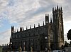 |
| St. Nicholas' Church (Roman Catholic)[49] | The site was levelled and the foundations cleared out in February 1859, dedication of the Church was in August 1860. Contains a shrine to the local born St. Bridget. | 54°0′35.03″N 6°24′9.1″W / 54.0097306°N 6.402528°W / 54.0097306; -6.402528 | |
| St Joseph's Redemptorist Church[50] | The community of Redemptorists, or missionary priests, settled here in 1876.[51] Contains a relic of St. Gerard Majella. | 54°0′15.2″N 6°23′21.8″W / 54.004222°N 6.389389°W / 54.004222; -6.389389 | |
| Parish Church of Saint Nicholas (Anglican Church of Ireland) | Known locally as the Green Church due to its green copper spire. Contains epitaph erected to the memory of Scotland's National Bard, Robert Burns and whose sister Agnes Burns/Galt and her husband William Galt who built Stephenstown Pond are buried here.[52] | 54°0′30.53″N 6°24′5.81″W / 54.0084806°N 6.4016139°W / 54.0084806; -6.4016139 | 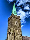 |
| Priory of St Malachy, Dominican chapel | The 'Carlingford Dominicans' official foundation in Dundalk was in 1777[53] | 54°0′1.69″N 6°24′31.09″W / 54.0004694°N 6.4086361°W / 54.0004694; -6.4086361 | |
| Saint Brigid's Shrine[54][55] | 54°3′11.3″N 6°23′53.24″W / 54.053139°N 6.3981222°W / 54.053139; -6.3981222 | ||
| St Brigid's Well | Holy Well dedicated to St. Brigid | 54°3′6.09″N 6°23′2.06″W / 54.0516917°N 6.3839056°W / 54.0516917; -6.3839056 | |
| St Bridget's Church, Kilcurry | Holds a relic of St Bridget – a fragment of her skull was brought here in 1905 by Sister Mary Agnes of the Dundalk Convent of Mercy | 54°2′33.57″N 6°25′31.99″W / 54.0426583°N 6.4255528°W / 54.0426583; -6.4255528 | |
Castle Roche | Norman castle, the seat of the De Verdun family, who built the castle in 1236 AD. | 54°2′47″N 6°29′18″W / 54.04639°N 6.48833°W / 54.04639; -6.48833 | 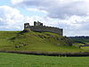 |
Proleek Dolmen[56] | One of the finest examples of its kind in Ireland | 54°2′13.86″N 6°20′53.75″W / 54.0371833°N 6.3482639°W / 54.0371833; -6.3482639 | |
| Proleek Wedge Tomb | 54°2′12.84″N 6°20′49.88″W / 54.0369000°N 6.3471889°W / 54.0369000; -6.3471889 | ||
| Franciscan friary | Founded 1246[57] | 54°0′22.51″N 6°23′37.92″W / 54.0062528°N 6.3938667°W / 54.0062528; -6.3938667 |  |
| Windmill Tower | An eight-storey windmill-tower, built around 1800. | 54°0′21.14″N 6°23′21.22″W / 54.0058722°N 6.3892278°W / 54.0058722; -6.3892278 | |
| Our Lady's Well / Ladywell | Pattern takes place here on 15 August, during the feast of the assumption. | 53°59′36.91″N 6°24′8.23″W / 53.9935861°N 6.4022861°W / 53.9935861; -6.4022861 | |
| Cloghafarmore (Cuchulains / Cú Chulainn Stone) | Standing stone on which Cú Chulainn tied himself to after his battle with Lugaid in order to die on his feet, facing his enemies. | 53°58′28″N 6°27′58″W / 53.974484°N 6.465991°W / 53.974484; -6.465991 | 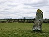 |
| Dromiskin Round Tower & High Crosses | Founded by a disciple of St Patrick, Lughaidh (unknown – 515AD) | 53°55′19.24″N 6°23′53.55″W / 53.9220111°N 6.3982083°W / 53.9220111; -6.3982083 | 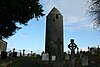 |
Cú Chulainn Castle / Dun Dealgan Castle / Castletown Motte / Byrne's Folly | Built in the late 11th century by Bertram de Verdun, a later addition was the castellated house known as 'Byrne's Folly' built in 1780 by a local pirate named Patrick Byrne. | 54°0′49.77″N 6°25′48.82″W / 54.0138250°N 6.4302278°W / 54.0138250; -6.4302278 | 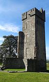 |
Magic Hill | A place where the layout of the surrounding land produces the optical illusion that a very slight downhill slope appears to be an uphill slope. Thus, a car left out of gear will appear to be rolling uphill against gravity.[58] | 54°1′19.6″N 6°17′31.86″W / 54.022111°N 6.2921833°W / 54.022111; -6.2921833 | |
| Long Woman's Grave or "The Cairn of Cauthleen" | The grave of a Spanish noble woman, Cauthleen, who married Lorcan O’Hanlon, the youngest son of the "Cean" or Chieftain of Omeath.[59] Her grave is known as the "Lug Bhan Fada" (long woman’s hollow).[59] | 54°3′40.63″N 6°16′28.85″W / 54.0612861°N 6.2746806°W / 54.0612861; -6.2746806 | |
Rockmarshall Court Tomb | 14 metres long cairn. | 54°0′33″N 6°17′5″W / 54.00917°N 6.28472°W / 54.00917; -6.28472 | |
| Dunmahon Castle | Ruins of four storeys tower-house with vault over ground floor. In 1659 it was the residence of Henry Townley. | 53°57′27.48″N 6°25′19.4″W / 53.9576333°N 6.422056°W / 53.9576333; -6.422056 | |
| Haynestown castle | 3-storey square tower house with corner turrets | 53°57′36.47″N 6°24′40.85″W / 53.9601306°N 6.4113472°W / 53.9601306; -6.4113472 | |
| Milltown Castle | 15th century Norman keep about 55 feet high built by the Gernon family. | 53°55′58.77″N 6°25′34.23″W / 53.9329917°N 6.4261750°W / 53.9329917; -6.4261750 | |
| Knockabbey Castle and Gardens | Originally built in 1399, the historical water gardens originally date from the 11th century. | 53°55′47.61″N 6°35′7.01″W / 53.9298917°N 6.5852806°W / 53.9298917; -6.5852806 | |
| Louth Hall Castle | Ruins originally built in the 14th century in gothic design, it was later extended in the 18th and 19th century in Georgian design. Home of the Plunkett family, Lords of Louth | 53°54′44.01″N 6°33′11.56″W / 53.9122250°N 6.5532111°W / 53.9122250; -6.5532111 | |
Roodstown Castle | Dates from the 15th century, features two turrets. | 53°52′20.11″N 6°29′12.07″W / 53.8722528°N 6.4866861°W / 53.8722528; -6.4866861 | |
| Aghnaskeagh Cairn and Portal Tomb | 54°3′40.59″N 6°21′28.6″W / 54.0612750°N 6.357944°W / 54.0612750; -6.357944 | ||
| Faughart Round Tower | Remains of a monastery founded by St Moninna in the 5th century. | 54°3′6.11″N 6°23′4.18″W / 54.0516972°N 6.3844944°W / 54.0516972; -6.3844944 | |
| Grave of Edward Bruce | Proclaimed High King of Ireland before he was killed in the battle of Faughart in 1318 | 54°3′6.11″N 6°23′4.18″W / 54.0516972°N 6.3844944°W / 54.0516972; -6.3844944 | |
| Faughart Motte | 54°3′8.07″N 6°23′9.67″W / 54.0522417°N 6.3860194°W / 54.0522417; -6.3860194 | ||
| Kilwirra Church, Templetown | St Mary's Church at Templetown, associated with the Knights Templar founded in 1118 by Hugh de Payens. | 53°59′10.33″N 6°9′18.51″W / 53.9862028°N 6.1551417°W / 53.9862028; -6.1551417 | |
| Lady Well, Templetown | 53°59′14.74″N 6°9′10.79″W / 53.9874278°N 6.1529972°W / 53.9874278; -6.1529972 | ||
| Ardee Castle | The largest fortified medieval Tower House in Ireland or Britain, founded by Roger de Peppard in 1207, the current building was built in the 15th century by John St. Ledger. James II used it as his headquarters for a month prior to the Battle of the Boyne. | 53°51′18.43″N 6°32′19.7″W / 53.8551194°N 6.538806°W / 53.8551194; -6.538806 | |
| Hatch's Castle, Ardee | Medieval Tower House | 53°51′24.99″N 6°32′22.22″W / 53.8569417°N 6.5395056°W / 53.8569417; -6.5395056 | |
| Kildemock Church 'The Jumping Church' | 14th century Church built on the site of the Church of Deomog (Cill Deomog), under the control of the Knights Templar until 1540. | 53°50′8.96″N 6°31′14.28″W / 53.8358222°N 6.5206333°W / 53.8358222; -6.5206333 | |
| St Mary's Priory | Augustinian Priory stands on the site where St Mochta established a monastery in 528 CE. | 53°57′11.68″N 6°32′38.97″W / 53.9532444°N 6.5441583°W / 53.9532444; -6.5441583 | |
| St Mochta's House | 12th Century Church/Oratory. | 53°57′12.33″N 6°32′43.36″W / 53.9534250°N 6.5453778°W / 53.9534250; -6.5453778 | |
| St James' Well | 54°1′11.03″N 6°8′38.83″W / 54.0197306°N 6.1441194°W / 54.0197306; -6.1441194 | ||
| Liberties of Carlingford | Medieval Head Carving | 54°2′31.47″N 6°11′13.81″W / 54.0420750°N 6.1871694°W / 54.0420750; -6.1871694 | |
The Mint of Carlingford | Mint established in 1467 | 54°2′25.06″N 6°11′11.02″W / 54.0402944°N 6.1863944°W / 54.0402944; -6.1863944 | |
| Tallanstown Motte | 53°55′15.12″N 6°32′59.53″W / 53.9208667°N 6.5498694°W / 53.9208667; -6.5498694 | ||
Dominican Priory of Carlingford | Founded by Richard de Burgh in 1305 | 54°2′17.33″N 6°11′4.13″W / 54.0381472°N 6.1844806°W / 54.0381472; -6.1844806 | |
King John's Castle (Carlingford) | Commissioned by Hugh de Lacy before 1186, the castle owes its name to King John (Richard the Lionheart's brother) who visited Carlingford in 1210. | 54°2′35.7″N 6°11′12.3″W / 54.043250°N 6.186750°W / 54.043250; -6.186750 |  |
Carlingford Lough | A glacial fjord that forms part of the border between Northern Ireland to the north and Ireland to the south. On its northern shore is County Down and on its southern shore is County Louth. At its extreme interior angle (the northwest corner) it is fed by the Newry River and the Newry Canal. | 54°2′35.7″N 6°11′12.3″W / 54.043250°N 6.186750°W / 54.043250; -6.186750 |  |
| Ravensdale Forest, Ravensdale, County Louth | 54°03′08″N 6°20′23″W / 54.05222°N 6.33972°W / 54.05222; -6.33972 | 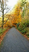 |
Arts and festivals
Dundalk has two photography clubs – Dundalk Photographic Society[60] and the Tain Photographic Club. In 2010 Dundalk Photographic Society won the FIAP Photography Club World Cup.[61]
Dundalk has a vibrant music environment.
- The Fr. McNally Chamber Orchestra created in April 2010.[62] It is a string chamber orchestra made of violins, violas, double basses and cellos and has 29 members.
- The Cross Border Orchestra of Ireland[63] (CBOI) which is one of Ireland's primary youth orchestras. It is based in the Dundalk Institute of Technology and maintains a membership of 160 young musicians between the ages of 12 and 24 years. The CBOI was established in 1995 shortly after the implementation of the Peace Process and is recognised internationally and one of Ireland's flagship peace initiatives. The CBOI tours regularly to Europe and America and has sold out such prestigious venues as Carnegie Hall, New York and Chicago Symphony Hall.
- The Clermont Chorale.[64] It was formed in 2003 and has 30 members, drawn from all parts of County Louth. Its repertoire includes music from the 17th to the 21st century, across many styles and genres.
- Dundalk School of Music.[65] Created in February 2010, it aims to provide education in music for all age groups in many disciplines.
- Historic Dundalk Gaol is the home of The Oriel Centre – a regional centre for Comhaltas Ceoltoirí Éireann. The Oriel Centre Dundalk Gaol.[66] opened in October 2010 and focuses on the promotion of Traditional Irish music, song dance and the Irish language.
| |||||||||||||||||||||||||||||||||||||||||||||||||||||||||||||||||||||||||||||||||||||||||||


| Council members from 2014 election | |||
|---|---|---|---|
| Local electoral area | Name | Party | |
| Dundalk-Carlingford Population: 24,589 | Edel Corrigan | Sinn Féin | |
| Jim Loughran | Sinn Féin | ||
| Peter Savage | Fianna Fáil | ||
| John McGahon | Fine Gael | ||
| Conor Keelan | Fianna Fáil | ||
Mark Dearey | Green Party | ||
| Dundalk South Population: 28,493 | Tomás Sharkey | Sinn Féin | |
| Declan Breathnach | Fianna Fáil | ||
| Maeve Anna Yore | Independent | ||
| Kevin Meenan | Sinn Féin | ||
| Jennifer Green | Sinn Féin | ||
| Marianne Butler | Green Party | ||
| Maria Doyle | Fine Gael | ||
Dáil Éireann /dɔɪl ˈɛərən/[98] is the lower house, and principal chamber, of the Oireachtas (the Irish legislature; which also includes the President of Ireland, and the upper house or Seanad Éireann).
Dundalk is represented in Dáil Éireann by the Louth parliamentary constituency.
Notable people
Arts and Media
Paul Vincent Carroll (1900–1968), playwright who founded two theater groups in Glasgow, Scotland: the Curtain Theatre in 1933 and the Glasgow Citizens' Theatre in 1943
The Corrs, Celtic folk rock group and family (Andrea, Sharon, Caroline, and Jim Corr), born and raised in Dundalk
Maria Cuche, singer who represented Ireland in the 1985 Eurovision Song Contest, finishing 6th
The Flaws, indie rock band
Catherine Gaskin (1929–2009), romance novelist
Donald Macardle (1900–1984), actor, screenwriter, and director
Dorothy Macardle (1889–1958), revolutionary, author and playwright
Cathy Maguire, singer-songwriter; currently lives in the United States
Dawn Martin, singer who represented Ireland in the 1998 Eurovision concert, finishing 9th
Patrick McDonnell, actor in Naked Camera and Father Ted
John Moore, film director, producer, and writer
Brendan O'Dowda (1925–2002), Irish tenor who popularised the songs of Percy French
Liam Reilly, singer who represented Ireland in the 1990 Eurovision Song Contest, finishing 2nd; singer in the group Bagatelle
Thomas MacAnna (1926–2011), Tony Award-winning theatre director and playwright
Molly Barton (1861-1949), artist
Academia and Science
Nicholas Callan, scientist who made the first induction coil; went to primary school here
Thomas Coulter (1793–1843), botanist and doctor
Richard FitzRalph (c. 1300 – 16 December 1360), Vice-Chancellor of the University of Oxford; Archbishop of Armagh from 1346 to 1360; his remains are interred at St Nicholas's Church
John Phillip Holland, inventor of the submarine, worked as a teacher in Colaiste Ris, Dundalk
Peter Kerley, radiologist known for describing Kerley lines of heart failure
Peter Rice (1935–1992), engineer, worked on the Sydney Opera House, Louvre Pyramid and Centre Pompidou
Laurie Winkless, physicist and science writer
Politics
Gerry Adams, Teachta Dála (TD) for Louth-Dundalk constituency since 2011
Dermot Ahern, local solicitor, Fianna Fáil party politician and pension collector. Formerly Ireland; Minister for Social, Community and Family Affairs (1997–2002), Minister for Communications, Marine and Natural Resources (2002–04), Minister for Foreign Affairs (2004–08) and Minister for Justice and Law Reform (2008–11)
Edward Haughey (1944–2014), entrepreneur and politician
Brendan McGahon, former Fine Gael TD
Religion
- Saint Brigit of Kildare (c. 453 – c. 524)
Sport
Tommy Byrne, former Formula 1 racing driver
David Kearney, rugby player
Rob Kearney, rugby player, current player for both Leinster and Ireland
Jim McQuillan, Irish international darts player
Steve Staunton, former football player and former Republic of Ireland national football team manager
Tom Sharkey (1873–1953), heavyweight boxer
Tommy Traynor (1933–2006), former footballer, Republic of Ireland national football team and Southampton FC left-back
Military
Cú Chulainn, aka Sétanta[citation needed]
Francis Leopold McClintock, Royal Navy Rear Admiral, Arctic explorer, discoverer of the fate of Franklin
Business
Larry Goodman, entrepreneur in the beef industry. #22 on the Irish Independent Rich List 2017.[99]
- Dr Pearse Lyons, entrepreneur; President of Kentucky-based Alltech Inc.; proposed the sister cities twinning with the City of Pikeville, Kentucky. #5 on the Irish Independent Rich List 2017.[99]
- Henry McShane, established the McShane Bell Foundry; namesake of Dundalk, Maryland.
Martin Naughton, entrepreneur founded GlenDimplex. #11 on the Irish Independent Rich List 2017.[99]
Twinning / sister cities
Dundalk is twinned with the following places:
 Rezé, France (1990)[100]
 Pikeville, Kentucky, United States (2015)[101]
Namesakes
World towns named after Dundalk:
Dundalk, Maryland, United States – founded 1856
 Dundalk, Ontario, Canada – incorporated 1887
Areas:
Dundalk Mountain, Yukon Territory, Canada
Roads:
- Dundalk Road, Crossmaglen, Northern Ireland
- Dundalk Road, Cullyhanna, Northern Ireland
 Dundalk Rd, London SE4 2JJ, United Kingdom
Dundalk Rd, Widnes, Cheshire, United Kingdom
See also
- List of abbeys and priories in County Louth
- List of towns and villages in Ireland
Dundalk, which existed until the Act of Union in 1800
Dundalk, which existed 1801–1885
References
^ "Dundalk - Carlingford and Mourne"..mw-parser-output cite.citation{font-style:inherit}.mw-parser-output q{quotes:"""""""'""'"}.mw-parser-output code.cs1-code{color:inherit;background:inherit;border:inherit;padding:inherit}.mw-parser-output .cs1-lock-free a{background:url("//upload.wikimedia.org/wikipedia/commons/thumb/6/65/Lock-green.svg/9px-Lock-green.svg.png")no-repeat;background-position:right .1em center}.mw-parser-output .cs1-lock-limited a,.mw-parser-output .cs1-lock-registration a{background:url("//upload.wikimedia.org/wikipedia/commons/thumb/d/d6/Lock-gray-alt-2.svg/9px-Lock-gray-alt-2.svg.png")no-repeat;background-position:right .1em center}.mw-parser-output .cs1-lock-subscription a{background:url("//upload.wikimedia.org/wikipedia/commons/thumb/a/aa/Lock-red-alt-2.svg/9px-Lock-red-alt-2.svg.png")no-repeat;background-position:right .1em center}.mw-parser-output .cs1-subscription,.mw-parser-output .cs1-registration{color:#555}.mw-parser-output .cs1-subscription span,.mw-parser-output .cs1-registration span{border-bottom:1px dotted;cursor:help}.mw-parser-output .cs1-hidden-error{display:none;font-size:100%}.mw-parser-output .cs1-visible-error{font-size:100%}.mw-parser-output .cs1-subscription,.mw-parser-output .cs1-registration,.mw-parser-output .cs1-format{font-size:95%}.mw-parser-output .cs1-kern-left,.mw-parser-output .cs1-kern-wl-left{padding-left:0.2em}.mw-parser-output .cs1-kern-right,.mw-parser-output .cs1-kern-wl-right{padding-right:0.2em}
^ ab "Dundalk". 20 March 2009.
^ "eOceanic". www.inyourfootsteps.com.
^ "Census 2011 – Population Classified by Area Table 6 – Population and area of each Province, County, City, urban area, rural area and Electoral Division, 2011 and 2006" (PDF). Census 2011, Volume 1 – Population Classified by Area. Central Statistics Office. 25 April 2012. p. 13. Retrieved 17 February 2014.
^ "Settlement Dundalk". Central Statistics Office. 2016. Retrieved 2 June 2018.
^ "Dún Dealgan/Dundalk". Logainm.ie.
^ "Lebor Gabála Érenn". Oxford University Press. 1 January 2000. Retrieved 22 May 2012.
^ Archiseek: The Architecture of Ireland. History of the Castle.
^ Scoil Phádraig Naofa Kilcurry, County Louth, Ireland
^ "Dundalk". www.libraryireland.com.
^ O'Sullivan, Harold (1977-01-01). "The Cromwellian and Restoration Settlements in the Civil Parish of Dundalk, 1649 to 1673". Journal of the County Louth Archaeological and Historical Society. 19 (1): 24–58. doi:10.2307/27729438. JSTOR 27729438.
^ Census for post 1821 figures. Archived 20 September 2010 at the Wayback Machine.
^ [1]Archived 7 May 2016 at the Wayback Machine.
^ NISRA – Northern Ireland Statistics and Research Agency (c) 2013 Archived 17 February 2012 at the Wayback Machine.. Nisranew.nisra.gov.uk (27 September 2010). Retrieved on 23 July 2013.
^ Lee, JJ (1981). "Pre-famine". In Goldstrom, J. M.; Clarkson, L. A. Irish Population, Economy, and Society: Essays in Honour of the Late K. H. Connell. Oxford, England: Clarendon Press.
^ Mokyr, Joel; O Grada, Cormac (November 1984). "New Developments in Irish Population History, 1700–1850". The Economic History Review. 37 (4): 473–488. doi:10.1111/j.1468-0289.1984.tb00344.x.
^ Systems, Adlib Information. "Internet Server 3.1.1". www.louthcoco.ie.
^ Joseph Gavin and Harol O'Sullivan. Dundalk: A Military History. (Dundalk: Dundalgan Press Ltd., 1987), pp.109–137.
^ Dundalk Gaol interpretive centre Archived 27 September 2013 at the Wayback Machine. website
^ "Dundalk locals win the battle to keep the economy of the town they love so well alive".
^ Dundalk Digital Atlas | Earls of Roden, from the Jocelyn family Archived 2 February 2016 at the Wayback Machine.
^ Fiona Gartland, "Freehold of Dundalk sold at auction" in The Irish Times dated 22 July 2006
^ D'Alton, John (1864). The history of Dundalk and Its Environs: From the Earliest Historic Period to the present time. William Tempest. p. 8.
^ D'Alton, John (1864). The history of Dundalk and Its Environs: From the Earliest Historic Period to the present time. William Tempest. p. 10.
^ D'Alton, John (1845). The history of Ireland: from the earliest period to the year 1245, Vol II. Published by the author. p. 148.
^ Donnchadha, Pádraig Mac (8 June 2010). "History of Vikings in Ireland".
^ "RootsWeb.com Home Page". www.rootsweb.ancestry.com.
^ "The Munster Army at the Battle of Dundalk". www.libraryireland.com.
^ D'Alton, John (1864). The history of Dundalk and Its Environs: From the Earliest Historic Period to the present time. William Tempest. p. 12.
^ D'Alton, John (1845). The history of Ireland: from the earliest period to the year 1245, Vol II. Published by the author. p. 49.
^ "Battle of Dundalk, 14 October 1318". www.historyofwar.org.
^ D'Alton, John (1864). The history of Dundalk and Its Environs: From the Earliest Historic Period to the present time. William Tempest. p. 88.
^ D'Alton, John (1864). The history of Dundalk and Its Environs: From the Earliest Historic Period to the present time. William Tempest. p. 110.
^ D'Alton, John (1864). The history of Dundalk and Its Environs: From the Earliest Historic Period to the present time. William Tempest. p. 310.
^ D'Alton, John (1864). The history of Dundalk and Its Environs: From the Earliest Historic Period to the present time. William Tempest. p. 174.
^ "Battle of Courtbane attracts world media - Independent.ie".
^ "Dundalk bombing report, Ludlow murder expected in few weeks - Independent.ie".
^ "Home Page: The Dundalk Bombing, 19 December 1975". www.michael.donegan.care4free.net.
^ Flood, W. H. Grattan (29 March 1899). "The De Verdons of Louth". The Journal of the Royal Society of Antiquaries of Ireland. 9 (4): 417–419. JSTOR 25507007.
^ "Heraldry of the world - Category:Irish municipalities". www.ngw.nl.
^ abc "Dundalk Migration, Ethnicity and Religion (CSO Area Code LT 10008)". Central Statistics Office. 2006.
^ "Dundalk Migration, Ethnicity and Religion (CSO Area Code LT 10008)". Central Statistics Office. 2011. Archived from the original on 29 October 2014.
^ "Dundalk Migration, Ethnicity, Religion and Foreign Languages". Central Statistics Office. 2017.
^ "Dundalk Migration, Ethnicity and Religion (CSO Area Code LT 10008)". Central Statistics Office. 2011. Archived from the original on 29 October 2014.
^ "Usually resident population by ethnic or cultural background". Central Statistics Office. 2017.
^ "Number of persons by religion (XLS 43KB), Row 147". Central Statistics Office. 2002.
^ "Dundalk Migration, Ethnicity and Religion (CSO Area Code LT 10008)". Central Statistics Office. 2011. Archived from the original on 29 October 2014.
^ "Population by religion". Central Statistics Office. 2017.
^ ab "HISTORY". www.stpatricksparishdundalk.org.
^ "About Us – St Joseph's Redemptorists Monastery". www.redemptoristsdundalk.ie.
^ Tibus, Website design and development by. "St Joseph's Redemptorist Church - Attractions - Churches, Abbeys and Monasteries - All Ireland - Republic of Ireland - Louth - Dundalk - Discover Ireland". www.discoverireland.ie.
^ "Robert Burns & the Louth connection". www.irishidentity.com.
^ Priory of St Malachy, Dundalk | History[permanent dead link]
^ ab "Home - Brigid of Faughart Festival - www.brigidoffaughart.ie". Brigid of Faughart.
^ Tibus, Website design and development by. "Saint Brigid's Shrine and Well Faughart - Attractions - Churches, Abbeys and Monasteries - All Ireland - Republic of Ireland - Louth - Dundalk - Discover Ireland". www.discoverireland.ie.
^ Tibus, Website design and development by. "Proleek Dolmen - Attractions - Museums and Attractions - All Ireland - Republic of Ireland - Louth - Dundalk - Discover Ireland". www.discoverireland.ie.
^ Franciscan friary Archived 27 February 2015 at the Wayback Machine.
^ "Can Things Roll Uphill?". math.ucr.edu.
^ ab "Archived copy". Archived from the original on 27 March 2015. Retrieved 6 March 2015.CS1 maint: Archived copy as title (link)
^ "Welcome to Dundalk Photographic Society". www.dundalkphoto.com.
^ FIAP 5th Club World Cup Results Page Archived 21 December 2010 at the Wayback Machine.
^ "Fr. McNally Chamber Orchestra". www.facebook.com.
^ The Cross Border Orchestra of Ireland Archived 5 September 2011 at the Wayback Machine.
^ "Clermont Chorale". www.facebook.com.
^ Dundalk School of Music Archived 2 March 2011 at the Wayback Machine.
^ Home – Oriel Centre. Orielcentre.ie. Retrieved on 23 July 2013.
^ "Carlingford & Cooley Peninsula - Official Destination Website". Carlingford & Cooley Peninsula.
^ "Home - The Táin March Festival - Ireland's Ancient East". www.tainmarch.net.
^ "Annagassan Viking Festival 2013, Viking festival, Dublin festival, Louth festival, Viking re-enactments, Viking battles, Viking lifestyle, Home". www.annagassanvikingfestival.ie.
^ "Knockbridge Vintage Club – Our Club Website". www.knockbridgevintageclub.com.
^ Festival of Horrors Archived 19 February 2015 at the Wayback Machine.
^ "Programme for Ardee Baroque 2012 – Create Louth". www.createlouth.ie.
^ Gaelscoil Dhún Dealgan Archived 29 November 2007 at the Wayback Machine.
^ Coláiste Lú
^ "O'Fiaich College, Secondary School".
^ *St. Vincent's Secondary School http://www.stv.ie/ *St. Vincent's Secondary School Check|url=value (help). Missing or empty|title=(help)
^ User, Super. "Home". colaistecc.ie.
^ "O Fiaich Institute of Further Education Dundalk". www.ofi.ie.
^ "Dundalk Leader". www.dundalkleader.com.
^ "Talk of the Town - News from Dundalk and north Louth". Talk of the Town.
^ "Dundalk FM » Dundalk's Local Community Radio Station". Dundalk FM.
^ "Dundalk F.C." Retrieved 2013-11-27.
^ "Dundalk Rugby Football Club". Archived from the original on 2 December 2013. Retrieved 27 November 2013.
^ AG, Novanet Internet Consulting. "2007 IIHF World Championship Div III". www.iihf.com.
^ RTE – 2007 Irish Racing Archived 4 May 2008 at the Wayback Machine.
^ Dundalk Institute of Technology | Sport>
^ "Louth Mavericks AFC". www.facebook.com.
^ IAFL 1 2017 – Louth Mavericks
^ "Dundalk Lawn Tennis and Badminton Club". www.dundalkracketsclub.com.
^ Welcome to Dundalk Lawn Tennis and Badminton club. Dundalkracketsclub.com. Retrieved on 23 July 2013.
^ Dundalk Cricket Club home page. Dundalkcricketclub.com. Retrieved on 23 July 2013.
^ Dundalk Snooker League Archived 25 March 2012 at the Wayback Machine.. Dundalk Snooker League. Retrieved on 23 July 2013.
^ "Cuchulainn Cycling Club - Catering for all Cyclists in Louth". www.dundalkcycling.com.
^ http://www.cuchulainncyclingpark.com
^ "Home - Louth County Council". www.louthcoco.ie.
^ "Services". Louth County Council. Retrieved 31 March 2011.
^ "2014 Local elections – Louth County Council". ElectionsIreland.org. Retrieved 5 June 2014.
^ "Dáil: definition of Dáil in Oxford dictionary (British & World English). Meaning, pronunciation and origin of the word". Oxford Language Dictionaries. Oxford University Press. 2013. Retrieved 30 November 2013.
^ abc "Rich List 2017". Irish Independent. Retrieved 14 January 2018.
^ Dundalk – Reze twinning page Archived 30 September 2007 at the Wayback Machine.
^ "Dundalk agrees to twin with Pikeville, Kentucky - Independent.ie".
External links
![]() Media related to Dundalk at Wikimedia Commons
Media related to Dundalk at Wikimedia Commons
- Official website
Places in County Louth | ||
|---|---|---|
County town: Dundalk | ||
| Towns |
|  |
| Villages and Townlands |
| |
| ||
Authority control |
|
|---|
[1]
^ "St Gerard's Novena gets underway in Dundalk this Sunday - Talk of the Town". Talk of the Town. 2017-10-07. Retrieved 2018-09-10.


