Sierra Madre del Sur
| Sierra Madre del Sur | |
|---|---|
 Snowfall in Sierra Madre del Sur | |
| Highest point | |
| Peak | (Cerro el Nacimiento[1]) |
| Elevation | 3,703 m (12,149 ft) |
| Coordinates | 17°55′41″N 100°18′0″W / 17.92806°N 100.30000°W / 17.92806; -100.30000Coordinates: 17°55′41″N 100°18′0″W / 17.92806°N 100.30000°W / 17.92806; -100.30000 |
| Dimensions | |
| Length | 1,000 km (620 mi) NW x SE[1] |
| Area | 143,447 km2 (55,385 sq mi) |
| Geography | |
 Sierra Madre del Sur, other major mountain ranges, and the Mexican Plateau | |
| Country | Mexico |
| States | Michoacan, Guerrero, Oaxaca |
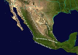
The Sierra Madre del Sur is a mountain range in southern Mexico, extending 1,000 kilometres (620 mi) from southern Michoacán east through Guerrero, to the Isthmus of Tehuantepec in eastern Oaxaca.
Contents
1 Geography
2 Ecology
3 References
4 External links
Geography

Sierra Madre del Sur (lower left), with other Isthmus of Tehuantepec ranges.
The Sierra Madre del Sur joins with the Eje Volcánico Transversal (Trans-Mexican Volcanic Belt) of central Mexico in northern Oaxaca, but is separated from this range further west by the valley of the Río Balsas and its tributary the Río Tepalcatepec.
The mountains' highest point is 3,703 metres (12,149 ft), located at 17°33′N 100°18′W / 17.550°N 100.300°W / 17.550; -100.300 in central Guerrero, and just one major highway crosses the range between Acapulco and Mexico City.[2]
Although separated from the main part of the Sierra Madre del Sur by the deep canyon of the lower Río Balsas, the mountains of southern Michoacán around Coalcomán are usually considered part of the Sierra Madre del Sur.
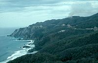
Sierra Madre del Sur on the coast west of Playa Azul, in Michoacán.

Ecology
The range is noted for its very high biodiversity and large number of endemic species.
The Sierra Madre del Sur pine-oak forests ecoregion occupies the higher reaches of the range. These forests are part of a chain of Mesoamerican pine-oak forests that stretch from the Southwestern United States to Costa Rica along the American Cordillera.
Lower elevations of the range are covered by tropical dry forests, ecoregions in the Tropical and subtropical dry broadleaf forests Biome. The Jalisco dry forests occupy the western end of the range's Pacific slope. The Southern Pacific dry forests occupy most of the Pacific slope of the range, from Michoacan in the west through Guerrero and Oaxaca. The basin of the Balsas River, north of the Sierra, is home to the Balsas dry forests.

References
^ ab "Sierra Madre del Sur". Peakbagger.com. Retrieved 17 March 2013..mw-parser-output cite.citation{font-style:inherit}.mw-parser-output .citation q{quotes:"""""""'""'"}.mw-parser-output .citation .cs1-lock-free a{background:url("//upload.wikimedia.org/wikipedia/commons/thumb/6/65/Lock-green.svg/9px-Lock-green.svg.png")no-repeat;background-position:right .1em center}.mw-parser-output .citation .cs1-lock-limited a,.mw-parser-output .citation .cs1-lock-registration a{background:url("//upload.wikimedia.org/wikipedia/commons/thumb/d/d6/Lock-gray-alt-2.svg/9px-Lock-gray-alt-2.svg.png")no-repeat;background-position:right .1em center}.mw-parser-output .citation .cs1-lock-subscription a{background:url("//upload.wikimedia.org/wikipedia/commons/thumb/a/aa/Lock-red-alt-2.svg/9px-Lock-red-alt-2.svg.png")no-repeat;background-position:right .1em center}.mw-parser-output .cs1-subscription,.mw-parser-output .cs1-registration{color:#555}.mw-parser-output .cs1-subscription span,.mw-parser-output .cs1-registration span{border-bottom:1px dotted;cursor:help}.mw-parser-output .cs1-ws-icon a{background:url("//upload.wikimedia.org/wikipedia/commons/thumb/4/4c/Wikisource-logo.svg/12px-Wikisource-logo.svg.png")no-repeat;background-position:right .1em center}.mw-parser-output code.cs1-code{color:inherit;background:inherit;border:inherit;padding:inherit}.mw-parser-output .cs1-hidden-error{display:none;font-size:100%}.mw-parser-output .cs1-visible-error{font-size:100%}.mw-parser-output .cs1-maint{display:none;color:#33aa33;margin-left:0.3em}.mw-parser-output .cs1-subscription,.mw-parser-output .cs1-registration,.mw-parser-output .cs1-format{font-size:95%}.mw-parser-output .cs1-kern-left,.mw-parser-output .cs1-kern-wl-left{padding-left:0.2em}.mw-parser-output .cs1-kern-right,.mw-parser-output .cs1-kern-wl-right{padding-right:0.2em}
^ Lee Stacy (October 2002). Mexico and the United States. Marshall Cavendish. p. 754. ISBN 978-0-7614-7402-9.
External links
| Wikimedia Commons has media related to Sierra Madre del Sur. |
"Sierra Madre del Sur pine-oak forests". Terrestrial Ecoregions. World Wildlife Fund.
World Wildlife Fund, ed. (2001). "Sierra Madre del Sur pine-oak forests". WildWorld Ecoregion Profile. National Geographic Society. Archived from the original on 2010-03-08.
Chilpancingo (capital) | |
| Municipalities/ (seats) |
|
Morelia (capital) | ||
| Municipalities and (municipal seats) |
|  |
Physical geography | ||
|---|---|---|
|  | |
| ||
Authority control |
|
|---|


