Natal (province)
| Province of Natal Provinsie van Natal | |
|---|---|
 | |
 | |
| Population | |
| • 1991 | 2,430,753[1] |
| History | |
| • Origin | Colony of Natal |
| • Created | 31 May 1910 |
| • Abolished | 27 April 1994 |
| • Succeeded by | KwaZulu-Natal |
| Status | Province of South Africa |
| Government | Natal Provincial Council |
| • HQ | Pietermaritzburg |
| Subdivisions | |
| • Type | Districts |
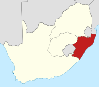
The Province of Natal (Afrikaans: Provinsie Natal), commonly called Natal, was a province of South Africa from 1910 until 1994. Its capital was Pietermaritzburg. During this period rural areas inhabited by the black African population of Natal were organized into the bantustan of KwaZulu, which was progressively separated from the province, becoming partially autonomous in 1981. Of the white population, the majority were English-speaking, causing Natal to become the only province to vote "no" to the creation of a republic in the referendum of 1960.[2] In the latter part of the 1980s, Natal was in a state of violence that only ended with the first multiracial election in 1994.[3]
In 1994, the KwaZulu bantustan was reincorporated into the territory of Natal and the province redesignated KwaZulu-Natal.
Contents
1 Districts in 1991
2 Administrators
3 See also
4 References
Districts in 1991
Districts of the province and population at the time of the 1991 census.[1]
Mount Currie (main town Kokstad): 41,564
Alfred (main town Harding): 8,794
Port Shepstone: 67,239
Umzinto: 46,919
Ixopo: 22,626
Polela: 4,364
Underberg: 9,584
Impendle: 2,815
Richmond: 23,476
Camperdown: 36,315
Pietermaritzburg: 228,549
Lions River: 43,060
New Hanover: 38,207
Mooirivier: 25,061
Estcourt: 49,493
Weenen: 12,485
Bergville: 22,552
Umvoti (main town Greytown): 41,160
Kranskop: 7,565
Durban: 473,826
Inanda (main town Verulam): 299,379
Pinetown: 184,216
Chatsworth: 179,957
Kliprivier: 64,782
Glencoe: 17,265
Dundee: 31,613
Dannhauser: 14,154
Newcastle: 53,584
Utrecht: 27,798
Paulpietersburg: 21,072
Vryheid: 85,518
Ngotshe: 26,382
Lower Tugela (main town Stanger): 96,702
Mtunzini: 18,455
Eshowe: 13,355
Mtonjaneni (main town Melmoth): 10,577
Babanango: 3,069
Lower Umfolozi (main town Empangeni): 56,082
Hlabisa: 18,211
Ubombo (main town Jozini): 2,929
Administrators
See also
- Coat of arms of Natal
Mtetwa Empire (c. 1750–1817)
Zululand (1816–1897)
Natalia Republic (1839–1843)
Colony of Natal (1843–1910)
KwaZulu-Natal (1994–)
References
^ ab "Census > 1991 > RSA > Variable Description > Person file > District code". Statistics South Africa - Nesstar WebView. Retrieved 18 August 2013..mw-parser-output cite.citation{font-style:inherit}.mw-parser-output .citation q{quotes:"""""""'""'"}.mw-parser-output .citation .cs1-lock-free a{background:url("//upload.wikimedia.org/wikipedia/commons/thumb/6/65/Lock-green.svg/9px-Lock-green.svg.png")no-repeat;background-position:right .1em center}.mw-parser-output .citation .cs1-lock-limited a,.mw-parser-output .citation .cs1-lock-registration a{background:url("//upload.wikimedia.org/wikipedia/commons/thumb/d/d6/Lock-gray-alt-2.svg/9px-Lock-gray-alt-2.svg.png")no-repeat;background-position:right .1em center}.mw-parser-output .citation .cs1-lock-subscription a{background:url("//upload.wikimedia.org/wikipedia/commons/thumb/a/aa/Lock-red-alt-2.svg/9px-Lock-red-alt-2.svg.png")no-repeat;background-position:right .1em center}.mw-parser-output .cs1-subscription,.mw-parser-output .cs1-registration{color:#555}.mw-parser-output .cs1-subscription span,.mw-parser-output .cs1-registration span{border-bottom:1px dotted;cursor:help}.mw-parser-output .cs1-ws-icon a{background:url("//upload.wikimedia.org/wikipedia/commons/thumb/4/4c/Wikisource-logo.svg/12px-Wikisource-logo.svg.png")no-repeat;background-position:right .1em center}.mw-parser-output code.cs1-code{color:inherit;background:inherit;border:inherit;padding:inherit}.mw-parser-output .cs1-hidden-error{display:none;font-size:100%}.mw-parser-output .cs1-visible-error{font-size:100%}.mw-parser-output .cs1-maint{display:none;color:#33aa33;margin-left:0.3em}.mw-parser-output .cs1-subscription,.mw-parser-output .cs1-registration,.mw-parser-output .cs1-format{font-size:95%}.mw-parser-output .cs1-kern-left,.mw-parser-output .cs1-kern-wl-left{padding-left:0.2em}.mw-parser-output .cs1-kern-right,.mw-parser-output .cs1-kern-wl-right{padding-right:0.2em}
^ Ingalls, Leonard (11 May 1961). "Resentment Grows in Natal". New York Times. Retrieved 2012-07-25.
^ Wren, Christopher S. (19 October 1990). "De Klerk Lifts Emergency Rule in Natal Province". New York Times. Retrieved 2012-07-25.
Wikisource has the text of the 1922 Encyclopædia Britannica article Natal. |
Administrative divisions of South Africa (1910–1994) | ||
|---|---|---|
| Provinces of South Africa |
|  |
| Non-independent homelands |
| |
| Independent homelands1 |
| |
| Dependent territories |
| |
| ||
| |||||||||||||||
| |||||||||||||||
| |||||||||||||||
| |||||||||||||||
| |||||||||||||||
| |||||||||||||||
| |||||||||||||||
| |||||||||||||||
| |||||||||||||||
Authority control |
|
|---|
Coordinates: 29°S 30°E / 29°S 30°E / -29; 30


