Buckenhof
Buckenhof | |
|---|---|
 Coat of arms | |
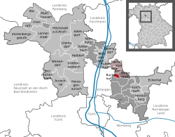
Location of Buckenhof within Erlangen-Höchstadt district  | |
 Buckenhof Show map of Germany  Buckenhof Show map of Bavaria | |
| Coordinates: 49°35′38″N 11°03′00″E / 49.59389°N 11.05000°E / 49.59389; 11.05000Coordinates: 49°35′38″N 11°03′00″E / 49.59389°N 11.05000°E / 49.59389; 11.05000 | |
| Country | Germany |
| State | Bavaria |
| Admin. region | Middle Franconia |
| District | Erlangen-Höchstadt |
| Municipal assoc. | Uttenreuth |
| Government | |
| • Mayor | Georg Förster |
| Area [1] | |
| • Total | 1.39 km2 (0.54 sq mi) |
| Elevation | 286 m (938 ft) |
| Population (2017-12-31)[2] | |
| • Total | 3,087 |
| • Density | 2,200/km2 (5,800/sq mi) |
| Time zone | CET/CEST (UTC+1/+2) |
| Postal codes | 91054 |
| Dialling codes | 09131 |
| Vehicle registration | ERH |
| Website | www.buckenhof.de |
Buckenhof is a town in the district of Erlangen-Höchstadt, in Bavaria, Germany.
History
The village called Buckenhof developed between the 11th and 12th century. The first public record is from 1372.
Between the years 1564 and 1567, the barons von Haller build the Puckenhof Castle.
Since 1850, it houses a youth center of the Inner Mission.
Between 1886 and 1963, Buckenhof was located along the branch line from Erlangen to Uttenreuth.
Population development
Together with the neighboring Erlangen, Buckenhof experienced a tremendous increase in its population after the Second World War. Since 2000, Buckenhof is one of the most densely populated communities in Bavaria. The extraordinary popularity of the village, which is due to Buckenhof's location near the industrial center of Erlangen and at the same time its proximity to a large nature preserve, has resulted in high land prices.
References
^ "Alle politisch selbständigen Gemeinden mit ausgewählten Merkmalen am 31.12.2018 (4. Quartal)". DESTATIS. Archived from the original on 10 March 2019. Retrieved 10 March 2019..mw-parser-output cite.citation{font-style:inherit}.mw-parser-output .citation q{quotes:"""""""'""'"}.mw-parser-output .citation .cs1-lock-free a{background:url("//upload.wikimedia.org/wikipedia/commons/thumb/6/65/Lock-green.svg/9px-Lock-green.svg.png")no-repeat;background-position:right .1em center}.mw-parser-output .citation .cs1-lock-limited a,.mw-parser-output .citation .cs1-lock-registration a{background:url("//upload.wikimedia.org/wikipedia/commons/thumb/d/d6/Lock-gray-alt-2.svg/9px-Lock-gray-alt-2.svg.png")no-repeat;background-position:right .1em center}.mw-parser-output .citation .cs1-lock-subscription a{background:url("//upload.wikimedia.org/wikipedia/commons/thumb/a/aa/Lock-red-alt-2.svg/9px-Lock-red-alt-2.svg.png")no-repeat;background-position:right .1em center}.mw-parser-output .cs1-subscription,.mw-parser-output .cs1-registration{color:#555}.mw-parser-output .cs1-subscription span,.mw-parser-output .cs1-registration span{border-bottom:1px dotted;cursor:help}.mw-parser-output .cs1-ws-icon a{background:url("//upload.wikimedia.org/wikipedia/commons/thumb/4/4c/Wikisource-logo.svg/12px-Wikisource-logo.svg.png")no-repeat;background-position:right .1em center}.mw-parser-output code.cs1-code{color:inherit;background:inherit;border:inherit;padding:inherit}.mw-parser-output .cs1-hidden-error{display:none;font-size:100%}.mw-parser-output .cs1-visible-error{font-size:100%}.mw-parser-output .cs1-maint{display:none;color:#33aa33;margin-left:0.3em}.mw-parser-output .cs1-subscription,.mw-parser-output .cs1-registration,.mw-parser-output .cs1-format{font-size:95%}.mw-parser-output .cs1-kern-left,.mw-parser-output .cs1-kern-wl-left{padding-left:0.2em}.mw-parser-output .cs1-kern-right,.mw-parser-output .cs1-kern-wl-right{padding-right:0.2em}
^ "Fortschreibung des Bevölkerungsstandes". Bayerisches Landesamt für Statistik und Datenverarbeitung (in German). September 2018.
This Erlangen-Höchstadt location article is a stub. You can help Wikipedia by expanding it. |