Font-Romeu-Odeillo-Via
Font-Romeu-Odeillo-Via
Jump to navigation
Jump to search
| Font-Romeu-Odeillo-Via | |
|---|---|
| Commune | |
 Church of St. Martin in Odeillo. | |
 Font-Romeu-Odeillo-Via Location within Occitanie region  Font-Romeu-Odeillo-Via | |
| Coordinates: 42°29′54″N 2°02′05″E / 42.4983°N 2.0347°E / 42.4983; 2.0347Coordinates: 42°29′54″N 2°02′05″E / 42.4983°N 2.0347°E / 42.4983; 2.0347 | |
| Country | France |
| Region | Occitanie |
| Department | Pyrénées-Orientales |
| Arrondissement | Prades |
| Canton | Les Pyrénées catalanes |
| Government | |
| • Mayor | Jean-Louis Demelin |
| Area1 | 29.60 km2 (11.43 sq mi) |
| Population (2007)2 | 1,992 |
| • Density | 67/km2 (170/sq mi) |
| Time zone | UTC+1 (CET) |
| • Summer (DST) | UTC+2 (CEST) |
INSEE/Postal code | 66124 /66120 |
| Elevation | 1,312–2,212 m (4,304–7,257 ft) (avg. 1,800 m or 5,900 ft) |
1 French Land Register data, which excludes lakes, ponds, glaciers > 1 km2 (0.386 sq mi or 247 acres) and river estuaries. 2Population without double counting: residents of multiple communes (e.g., students and military personnel) only counted once. | |
Font-Romeu-Odeillo-Via (Catalan: Font-romeu, Odelló i Vià), or simply Odeillo, is a commune in the Pyrénées-Orientales and Cerdagne near the Spanish border in the south of France. It comprises the villages of Odeillo and Via, as well as Font-Romeu, one of the oldest ski resorts in France and the oldest in the Pyrenees.
Contents
1 Geography
1.1 Localization
1.2 Transportation
2 Toponymy
3 History
4 Demography
5 Solar power
6 See also
7 External links
8 References
Geography[edit]
Localization[edit]
Font-Romeu-Odeillo-Via is located in the canton of Les Pyrénées catalanes and in the arrondissement of Prades. It is bordered by the communes of Angoustrine-Villeneuve-des-Escaldes, Targassonne, Égat, Estavar, Saillagouse, Eyne and Bolquère.

Map of Font-Romeu-Odeillo-Via and its surrounding communes
Transportation[edit]
- Font-Romeu-Odeillo-Via is served by the Yellow train line, a railway which runs from Villefranche-de-Conflent through to Mont-Louis.
Toponymy[edit]
The names of Odeillo and Via appear in 839 as parrochia Hodellone et parrochia Avizano.[1]
The name of Font-Romeu means in Catalan : fountain of the pilgrim.[1]
History[edit]
Odeillo and Via are both mentioned for the first time in 839 among the places paying a fee to La Seu d'Urgell church. Nevertheless, Odeillo was at the time part of the County of Cerdanya, while Via was a property of the Urg family.[1]
On 15 July 1035, Wifred II, Count of Cerdanya gives Odeillo to the Abbey of Saint-Martin-du-Canigou, where he retires himself a short time before his death. The Abbey of Saint-Michel-de-Cuxa also owned a few allods in Odeillo, as recognized by a papal bull from Sergius IV in 1011.[1]
Via remains a property of the Urg family until the 13th century. It is then bought by Peter of Fenouillet, viscount of Fenouillet and then viscount of Ille.[1]
A chapel is mentioned for the first time in Font-Romeu in 1525, on the territory of Odeillo. It already hosts a statue of the Virgin Mary from the 13th century, and a hermitage is built from 1693 to receive the pilgrims.[1]
Odeillo and Via both become communes in 1790. The commune of Via is abolished and included into Odeillo on 10 July 1822.[2]
In 1881, a wildfire caused by arson spread throughout 267 hectares of the forest of La Calme in the north of the commune.[3]
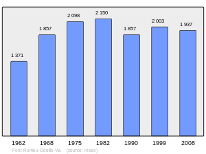
Demography[edit]

Solar power[edit]
- The world's largest solar furnace in Odeillo can reach temperatures up to 3,500 °C (6,330 °F).
THEMIS Solar Power R&D center is 3 km (1.9 mi) away in the village of Targassonne

The solar furnace at Odeillo
.
See also[edit]
- Communes of the Pyrénées-Orientales department
- Arboretum de Font-Romeu
External links[edit]
| Wikimedia Commons has media related to Font-Romeu-Odeillo-Via. |
- INSEE commune file
- L'invention d'une destination touristique
References[edit]
^ abcdef (in French) Jean Sagnes (dir.), Le pays catalan, t. 2, Pau, Société nouvelle d'éditions régionales, 1985
^ Jean-Pierre Pélissier, Paroisses et communes de France : dictionnaire d'histoire administrative et démographique, vol. 66 : Pyrénées-Orientales, Paris, CNRS, 1986
^ Fabricio Cardenas, Vieux papiers des Pyrénées-Orientales, Incendies de forêts en 1881, 13 February 2014
This Pyrénées-Orientales geographical article is a stub. You can help Wikipedia by expanding it. |
Categories:
- Communes of Pyrénées-Orientales
- Pyrénées-Orientales geography stubs
(window.RLQ=window.RLQ||).push(function(){mw.config.set({"wgPageParseReport":{"limitreport":{"cputime":"1.144","walltime":"1.376","ppvisitednodes":{"value":4626,"limit":1000000},"ppgeneratednodes":{"value":0,"limit":1500000},"postexpandincludesize":{"value":80729,"limit":2097152},"templateargumentsize":{"value":23355,"limit":2097152},"expansiondepth":{"value":26,"limit":40},"expensivefunctioncount":{"value":5,"limit":500},"unstrip-depth":{"value":0,"limit":20},"unstrip-size":{"value":2131,"limit":5000000},"entityaccesscount":{"value":1,"limit":400},"timingprofile":["100.00% 1245.281 1 -total"," 74.77% 931.069 1 Template:Infobox_French_commune"," 73.02% 909.263 1 Template:Infobox_settlement"," 63.13% 786.154 1 Template:Infobox"," 13.83% 172.230 1 Template:Lang-ca"," 4.66% 57.993 1 Template:Short_description"," 4.05% 50.378 4 Template:Convert"," 3.49% 43.443 7 Template:Both"," 3.35% 41.734 1 Template:Reflist"," 3.32% 41.373 2 Template:Location_map"]},"scribunto":{"limitreport-timeusage":{"value":"0.791","limit":"10.000"},"limitreport-memusage":{"value":12908948,"limit":52428800}},"cachereport":{"origin":"mw1252","timestamp":"20181116151534","ttl":1900800,"transientcontent":false}}});mw.config.set({"wgBackendResponseTime":87,"wgHostname":"mw1254"});});