File:PalmerLandstubmap.png
File:PalmerLandstubmap.png
Jump to navigation
Jump to search
- File
- File history
- File usage
- Global file usage
No higher resolution available.
PalmerLandstubmap.png (243 × 334 pixels, file size: 32 KB, MIME type: image/png)
| This is a file from the Wikimedia Commons. Information from its description page there is shown below. Commons is a freely licensed media file repository. You can help. |
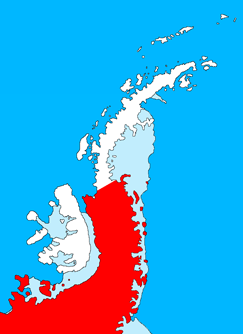
| DescriptionPalmerLandstubmap.png | English: Outline map of the Antarctic Peninsula showing Palmer Land. Drawn by me (User:Grutness) based on File:Ant-pen_map.png by Giovanni Fattori. |
| Date | 2 July 2011 (original upload date) |
| Source | Transferred from en.wikipedia to Commons. |
| Author | The original uploader was Grutness at English Wikipedia. |
Licensing
 | Permission is granted to copy, distribute and/or modify this document under the terms of the GNU Free Documentation License, Version 1.2 or any later version published by the Free Software Foundation; with no Invariant Sections, no Front-Cover Texts, and no Back-Cover Texts. A copy of the license is included in the section entitled GNU Free Documentation License.http://www.gnu.org/copyleft/fdl.htmlGFDLGNU Free Documentation Licensetruetrue |
Original upload log
The original description page was here. All following user names refer to en.wikipedia.
- 2011-07-02 09:39 Grutness 243×334× (33143 bytes) Outline map of the Antarctic Peninsula showing [[Palmer Land]]. Drawn by me (User:Grutness) based on [[:File:Ant-pen_map.png]] by Giovanni Fattori.{{GFDL}}
File history
Click on a date/time to view the file as it appeared at that time.
| Date/Time | Thumbnail | Dimensions | User | Comment | |
|---|---|---|---|---|---|
| current | 20:09, 9 July 2011 |  | 243 × 334 (32 KB) | MGA73bot2 | {{BotMoveToCommons|en.wikipedia|year={{subst:CURRENTYEAR}}|month={{subst:CURRENTMONTHNAME}}|day={{subst:CURRENTDAY}}}} {{Information |Description={{en|Outline map of the Antarctic Peninsula showing en:Palmer Land. Drawn by me (User:Grutness) base |
File usage
More than 100 pages use this file.
The following list shows the first 100 pages that use this file only.
A full list is available.
- Abendroth Peak
- Airy Glacier
- Arctowski Peak
- Auriga Nunataks
- Bates Peak
- Behrendt Mountains
- Black Coast
- Bowman Peninsula
- Buttress Nunataks
- Cape Adams
- Cape Agassiz
- Cape Brooks
- Cape Fiske
- Cape Jeremy
- Cape Kidson
- Cape Knowles
- Cape Schlossbach
- Cape Sharbonneau
- Cape Zumberge
- Desko Mountains
- Dolleman Island
- Du Toit Mountains
- Dyer Plateau
- Eklund Islands
- Engel Peaks
- English Coast
- Enigma Peak
- Eternity Range
- Ewing Island
- Faure Islands
- Gain Glacier
- Gardner Inlet
- George VI Ice Shelf
- Goward Peak
- Haag Nunataks
- Hauberg Mountains
- Imshaug Peninsula
- Irvine Glacier
- Isakson Nunatak
- Jaeger Hills
- James Nunatak
- Kemp Peninsula
- Ketchum Glacier
- Latady Mountains
- Merrick Mountains
- Merz Peninsula
- Morrill Peak
- Mount Aaron
- Mount Acton
- Mount Adkins
- Mount Austin (Antarctica)
- Mount Axworthy
- Mount Becker
- Mount Castro
- Mount Coman
- Mount Martin (Antarctica)
- Mount Owen (Antarctica)
- Mount Rex
- Mount Showers
- Mount Vang
- Mount Ward (Antarctica)
- New Bedford Inlet
- Odom Inlet
- Orville Coast
- Overton Peak
- Palmer Land
- Prehn Peninsula
- Procyon Peaks
- Prospect Glacier
- Quilty Nunataks
- Rothschild Island
- Rydberg Peninsula
- Scaife Mountains
- Schmitt Mesa
- Seward Mountains (Antarctica)
- Shabica Glacier
- Shelton Nunataks
- Simpson Hills
- Skytrain Ice Rise
- Smyley Island
- Spaatz Island
- Stange Ice Shelf
- Steele Island
- Sweeney Mountains
- Thuma Peak
- Ueda Glacier
- Utopia Glacier
- Wetmore Glacier
- Wilkins Coast
- Wilkins Mountains
- Willey Glacier
- Wilson Mountains
- Witte Nunataks
- Wordie Ice Shelf
- Wright Inlet
- Yates Glacier
- Yee Nunataks
- Zephyr Glacier
- Zohn Nunataks
- Zonda Glacier
Global file usage
The following other wikis use this file:
- Usage on az.wikipedia.org
- Palmer Torpağı
- Usage on ru.wikipedia.org
- Земля Палмера
- Usage on uk.wikipedia.org
- Земля Палмера
- Usage on www.wikidata.org
- Q25149852
(window.RLQ=window.RLQ||).push(function(){mw.config.set({"wgBackendResponseTime":308,"wgHostname":"mw1263"});});


