Manufahi Municipality
This article may be expanded with text translated from the corresponding article in German. (July 2011) Click [show] for important translation instructions.
|
| Manufahi | ||
|---|---|---|
| Municipality | ||
 Landscape between Dili and Same | ||
| ||
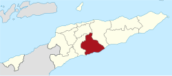
 Map of East Timor highlighting Manufahi Municipality | ||
| Coordinates: 9°00′S 125°47′E / 9.000°S 125.783°E / -9.000; 125.783Coordinates: 9°00′S 125°47′E / 9.000°S 125.783°E / -9.000; 125.783 | ||
| Country | ||
| Capital | Same | |
| Administrative posts |
| |
| Area | ||
| • Total | 1,323 km2 (511 sq mi) | |
| Area rank | 6th | |
| Population (2015 census) | ||
| • Total | 53,691 | |
| • Rank | 11th | |
| • Density | 41/km2 (110/sq mi) | |
| • Density rank | 11th | |
| Households (2015 census) | ||
| • Total | 9,023 | |
| • Rank | 11th | |
| Time zone | UTC+09:00 (TLT) | |
| ISO 3166 code | TL-MF | |
Manufahi (Portuguese: Município Manufahi, Tetum: Munisípiu Manufahi) is one of the municipalities of East Timor. It has a population of 53,691 (2015 census) and an area of 1,323 km².[1] The capital of the municipality is Same.[2]
Contents
1 Geography
2 History
3 Administrative posts
4 Demographics
5 References
6 External links
Geography
Manufahi lies on the south coast of East Timor, on the Timor Sea. It borders Manatuto to the east, Ainaro to the west, and Aileu to the north.
 Administrative posts of Manufahi |  Cities of Manufahi |
History
During its time as a Portuguese colony, the municipality was called Same, after the capital city. It was the epicentre of the Great Rebellion of 1910–12. During the Indonesian occupation the then subdistrict of Hato-Udo was split off from the then district of Manufahi and joined to Ainaro, and the then subdistrict of Turiscai, previously in Ainaro, was moved to Manufahi.
Administrative posts
Manufahi's administrative posts (formerly sub-districts) are:[3]
- Alas
- Fatuberlio
- Same
- Turiscai
Demographics
Besides the national official languages of Tetum and Portuguese, the Malayo-Polynesian language Mambai is also spoken.
References
^ Timor-Leste Population And Housing Census 2015 at the Wayback Machine (archived 2016-12-31)
^ Lansell Taudevin (1999). East Timor: Too Little Too Late. Duffy & Snellgrove. ISBN 18-759-8963-3..mw-parser-output cite.citation{font-style:inherit}.mw-parser-output q{quotes:"""""""'""'"}.mw-parser-output code.cs1-code{color:inherit;background:inherit;border:inherit;padding:inherit}.mw-parser-output .cs1-lock-free a{background:url("//upload.wikimedia.org/wikipedia/commons/thumb/6/65/Lock-green.svg/9px-Lock-green.svg.png")no-repeat;background-position:right .1em center}.mw-parser-output .cs1-lock-limited a,.mw-parser-output .cs1-lock-registration a{background:url("//upload.wikimedia.org/wikipedia/commons/thumb/d/d6/Lock-gray-alt-2.svg/9px-Lock-gray-alt-2.svg.png")no-repeat;background-position:right .1em center}.mw-parser-output .cs1-lock-subscription a{background:url("//upload.wikimedia.org/wikipedia/commons/thumb/a/aa/Lock-red-alt-2.svg/9px-Lock-red-alt-2.svg.png")no-repeat;background-position:right .1em center}.mw-parser-output .cs1-subscription,.mw-parser-output .cs1-registration{color:#555}.mw-parser-output .cs1-subscription span,.mw-parser-output .cs1-registration span{border-bottom:1px dotted;cursor:help}.mw-parser-output .cs1-hidden-error{display:none;font-size:100%}.mw-parser-output .cs1-visible-error{font-size:100%}.mw-parser-output .cs1-subscription,.mw-parser-output .cs1-registration,.mw-parser-output .cs1-format{font-size:95%}.mw-parser-output .cs1-kern-left,.mw-parser-output .cs1-kern-wl-left{padding-left:0.2em}.mw-parser-output .cs1-kern-right,.mw-parser-output .cs1-kern-wl-right{padding-right:0.2em}
^ Gunn, Geoffrey C (2011). "Manufahi District". Historical Dictionary of East Timor. Lanham, Maryland: Scarecrow Press. p. 124–125. ISBN 9780810867543.
External links
![]() Media related to Manufahi at Wikimedia Commons
Media related to Manufahi at Wikimedia Commons
This East Timor location article is a stub. You can help Wikipedia by expanding it. |
