Uxbridge tube station
| Uxbridge | |
|---|---|
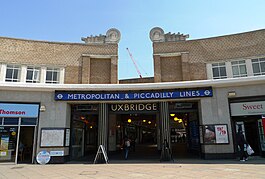 Main entrance | |
 Uxbridge Location of Uxbridge in Greater London | |
| Location | Uxbridge |
| Local authority | London Borough of Hillingdon |
| Managed by | London Underground |
| Number of platforms | 4 (facing 3 tracks) |
| Accessible | Yes[1] |
| Fare zone | 6 |
| London Underground annual entry and exit | |
| 2013 | |
| 2014 | |
| 2015 | |
| 2016 | |
| 2017 | |
| Key dates | |
| 1904 | Opened (Metropolitan) |
| 1910 | Start (District) |
| 1933 | End (District) |
| 1933 | Start (Piccadilly) |
| 1938 | Moved |
| 1 May 1939 | Goods yard closed[3] |
Listed status | |
| Listing grade | II |
| Entry number | 1358405[4] |
| Added to list | 12 January 1983 |
| Other information | |
| Lists of stations |
|
| External links |
|
| WGS84 | 51°32′45″N 0°28′42″W / 51.5459°N 0.4783°W / 51.5459; -0.4783Coordinates: 51°32′45″N 0°28′42″W / 51.5459°N 0.4783°W / 51.5459; -0.4783 |
Uxbridge is a London Underground station in Uxbridge in the London Borough of Hillingdon, north-west London. The station is the terminus of the Uxbridge branches of both the Metropolitan line and the Piccadilly line. The next station towards London is Hillingdon. The station is 15.5 miles (25 km) west of Charing Cross and is in Travelcard Zone 6. The closest station on the Chiltern Line and Central line is West Ruislip, accessible by the U1 and U10 buses. The closest station on the Great Western Main Line (in future Crossrail) is West Drayton, accessible by the U1, U3, U5 and 222 buses. Uxbridge was formerly the terminus of a branch of the District line which ran from Ealing Common; the Piccadilly line replaced the District line in 1933.
Contents
1 History
2 Design
3 Services
3.1 Metropolitan line
3.2 Piccadilly line
4 Connections
5 See also
6 References
7 External links
History
The Harrow and Uxbridge Railway (later merged into the Metropolitan Railway) first opened a station in Uxbridge on 4 July 1904 on Belmont Road, a short distance to the north of the existing station. The station was situated on a different track alignment, now used as sidings. The original service from central London was provided by steam-drawn trains but electrification took place the following year.

The original Uxbridge station at Belmont Road in October 1933
The London United Tramways extension from Shepherds Bush was opened a few weeks before the underground station. The manager, as reported in a local newspaper at the time, commented on the high prices of the underground journey: the tram journey however took well over an hour to reach Shepherds Bush.
On 1 March 1910, an extension of the District line from South Harrow to connect with the Metropolitan Railway at Rayners Lane was opened, enabling District line trains to serve stations between Rayners Lane and Uxbridge. The original Belmont Road station had two platforms, and after the introduction of shared operation one platform was used by each line.
On 23 October 1933 District line services to Uxbridge were replaced by Piccadilly line trains.
On 4 December 1938 the current station was opened on a new alignment.[5]
On 12 January 1983, the station buildings were given Grade II listed status.[6]
The London Borough of Hillingdon announced in June 2011 that it would be lobbying Transport for London to have the Central line diverted from West Ruislip station to Uxbridge. Such a project would require a business case approved by TfL and the completion of signal upgrade work on the Metropolitan line.[7]
Design

Ticket hall in February 2011 looking towards Uxbridge High Street entrance following refurbishment
The station was designed by Charles Holden with L H Bucknell and features a red-brick facade with paired sculptures by Joseph Armitage over the entrance, representing stylised "winged wheels" with leaf springs.[8] A tall concrete canopy arches over the tracks with a row of clerestory windows above the platforms. The canopy at Uxbridge is similar to the one at Cockfosters, the terminus at the other end of the Piccadilly line. The station is below street level in a cutting.
The stained glass panels by Erwin Bossanyi at the booking hall end of the platforms reflect the area's heraldic associations.[8] The crown and three seaxes on a red background are the arms of Middlesex County Council and the chained swan on a black and red background is associated with Buckinghamshire. The centre shield is possibly the arms of the local Basset family; a downward-pointing red triangle on a gold background was borrowed from the Bassett arms for use on the arms of Uxbridge Urban District Council in 1948.
The forecourt of the new station was originally laid out to provide a turning circle for trolleybuses, which replaced trams in 1936. Ticket barriers are in operation.
Services
Metropolitan line
The Metropolitan Line is the only line to operate an express service, though currently for Metropolitan Line trains on the Uxbridge branch this is eastbound only in the morning peaks (06:30 to 09:30) Monday to Friday.[9]
The off-peak service in trains per hour (tph) is:[9]
- 8tph to Aldgate (all stations)
- 8tph terminating at Uxbridge
The morning peak service in trains per hour (tph) is:[9]
- 2tph to Aldgate (semi-fast)
- 4tph to Aldgate (all stations)
- 4tph to Baker Street (all stations)
- 10tph terminating at Uxbridge
The evening peak service in trains per hour (tph) is:[9]
- 7tph to Aldgate (all stations)
- 3tph to Baker Street (all stations)
- 10tph terminating at Uxbridge
Piccadilly line
The off-peak service in trains per hour (tph) is:
- 3tph to Cockfosters
- 3tph terminating at Uxbridge
The peak time service in trains per hour (tph) is:
- 6tph to Cockfosters
- 6tph terminating at Uxbridge
Connections

Platforms 3 (right) and 4 looking east
London Buses routes:
222 (Uxbridge to Hounslow)
331 (Uxbridge to Ruislip)
427 (Uxbridge to Acton Old Town Hall) – this route acts as a shorter-distance stopping service of the 607.
A10 (Uxbridge to Heathrow Central)
U1 (Ruislip to West Drayton)
U2 (Uxbridge to Brunel University)
U3 (Uxbridge to Heathrow Central)
U4 (Uxbridge to Hayes Prologis Park)
U5 (Uxbridge to Hayes & Harlington)
U7 (Uxbridge to Hayes Sainsbury's)
U9 (Uxbridge to Harefield)
U10 (Uxbridge to Ruislip Heathfield Rise)- Express route 607 (Uxbridge to White City limited stop)
- Night route N207 (Uxbridge to Holborn)
In addition non-London Buses routes include:
First Berkshire route 3 (Uxbridge to Slough)
Carousel Buses route 580 (Uxbridge to High Wycombe)
Carousel Buses route 581 (Uxbridge to Beaconsfield) – branded as Buckinghamshire County Rider
Carousel Buses route 101/102 (High Wycombe to Uxbridge)
Carousel Buses route 105 (Hemel Hempstead to Uxbridge)- Magpie Travel route CC1 (Uxbridge to Newland Park College Campus)
- Red Rose route R21 (Uxbridge to Mount Vernon Hospital)
As well as the Green Line Coaches service:
Arriva Shires & Essex route 724 (Harlow to Heathrow) – branded as Green Line
See also
- Uxbridge High Street railway station
- Uxbridge Vine Street railway station
References
^ "Step free Tube Guide" (PDF). Transport for London. September 2018. Archived (PDF) from the original on 7 November 2018..mw-parser-output cite.citation{font-style:inherit}.mw-parser-output q{quotes:"""""""'""'"}.mw-parser-output code.cs1-code{color:inherit;background:inherit;border:inherit;padding:inherit}.mw-parser-output .cs1-lock-free a{background:url("//upload.wikimedia.org/wikipedia/commons/thumb/6/65/Lock-green.svg/9px-Lock-green.svg.png")no-repeat;background-position:right .1em center}.mw-parser-output .cs1-lock-limited a,.mw-parser-output .cs1-lock-registration a{background:url("//upload.wikimedia.org/wikipedia/commons/thumb/d/d6/Lock-gray-alt-2.svg/9px-Lock-gray-alt-2.svg.png")no-repeat;background-position:right .1em center}.mw-parser-output .cs1-lock-subscription a{background:url("//upload.wikimedia.org/wikipedia/commons/thumb/a/aa/Lock-red-alt-2.svg/9px-Lock-red-alt-2.svg.png")no-repeat;background-position:right .1em center}.mw-parser-output .cs1-subscription,.mw-parser-output .cs1-registration{color:#555}.mw-parser-output .cs1-subscription span,.mw-parser-output .cs1-registration span{border-bottom:1px dotted;cursor:help}.mw-parser-output .cs1-hidden-error{display:none;font-size:100%}.mw-parser-output .cs1-visible-error{font-size:100%}.mw-parser-output .cs1-subscription,.mw-parser-output .cs1-registration,.mw-parser-output .cs1-format{font-size:95%}.mw-parser-output .cs1-kern-left,.mw-parser-output .cs1-kern-wl-left{padding-left:0.2em}.mw-parser-output .cs1-kern-right,.mw-parser-output .cs1-kern-wl-right{padding-right:0.2em}
^ abcde "Multi-year station entry-and-exit figures" (XLSX). London Underground station passenger usage data. Transport for London. January 2018. Retrieved 22 July 2018.
^ Hardy, Brian, ed. (March 2011). "How it used to be – freight on The Underground 50 years ago". Underground News. London Underground Railway Society (591): 175–183. ISSN 0306-8617.
^ Historic England. "Uxbridge Underground Station (1358405)". National Heritage List for England. Retrieved 3 August 2013.
^ Pearce, K. R. (2009). Uxbridge From Old Photographs. Stroud: Amberley Publishing. p. 51. ISBN 978-1-84868-390-7.
^ Historic England. "Uxbridge Underground Station (1358405)". National Heritage List for England. Retrieved 25 July 2016.
^ Coombs, Dan (17 June 2011). "'Extending Central Line to Uxbridge will cut traffic'". Uxbridge Gazette. Archived from the original on 2011-06-30.
^ ab Cherry, Bridget; Pevsner, Nikolaus (1991). London 3: North West. The Buildings of England. Yale University Press. p. 362. ISBN 978-0-300-09652-1. Retrieved 5 February 2011.
^ abcd "CULG - Metropolitan Line". www.davros.org.
External links
| Wikimedia Commons has media related to Uxbridge tube station. |
- Departure board for Uxbridge station
- The Uxbridge Parish website
London Transport Photographic Archive
- Original station looking east, 1934
- Original station looking west, 1934
- One of the pair of sculptures in the artist's studio before installation
- Concrete canopy of new station in 1958
- Stained glass clerestory windows, 1982
| Preceding station | | | Following station | |
|---|---|---|---|---|
| Terminus | Metropolitan line | Hillingdon towards Baker Street or Aldgate | ||
Piccadilly line Uxbridge branch | Hillingdon towards Cockfosters | |||
| | Former services | | ||
| Preceding station | | | Following station | |
| Terminus | District line (1910–1933) | Hillingdon towards Upminster | ||
Metropolitan line | |||||||||||||||||
|---|---|---|---|---|---|---|---|---|---|---|---|---|---|---|---|---|---|
| Stations |
| ||||||||||||||||
| Rolling stock |
| ||||||||||||||||
| History |
| ||||||||||||||||
| Future proposals |
| ||||||||||||||||
| |||||||||||||||||
Piccadilly line | |||||||
|---|---|---|---|---|---|---|---|
| Stations |
| ||||||
| Rolling stock |
| ||||||
| History |
| ||||||
| |||||||
District line | |||||||||||
|---|---|---|---|---|---|---|---|---|---|---|---|
| Stations |
| ||||||||||
| Rolling stock |
| ||||||||||
| History |
| ||||||||||
| Depots |
| ||||||||||
| See also |
| ||||||||||
| |||||||||||