Kabul River
| Kabul | |
| River | |
 | |
| Country | Afghanistan |
|---|---|
Tributaries | |
| - left | Panjshir River, Alingar River, Kunar River, Swat River |
| - right | Logar River, Bara River |
| City | Kabul, Jalalabad (Afghanistan); Charsadda, Nowshera (Pakistan) |
| Source | Hindu Kush Mountains |
| - location | Maidan Wardak Province, Afghanistan |
| - elevation | 2,400 m (7,874 ft) |
| - coordinates | 34°21′25″N 68°50′21″E / 34.357°N 68.8392°E / 34.357; 68.8392 |
| Mouth | Indus River |
| - location | Attock, Punjab, Pakistan |
| - coordinates | 33°55′0″N 72°13′56″E / 33.91667°N 72.23222°E / 33.91667; 72.23222 |
| Length | 700 km (435 mi) |
| Basin | 66,000 km2 (25,483 sq mi) |
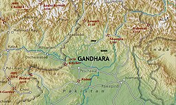 Ancient Gandhara with the Kabul River as its southern boundary | |
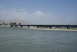
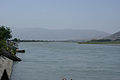
 Mouth of the Kabul River in Pakistan | |
The Kabul River (Dari: دریای کابل, Pashto: کابل سیند), the classical Cophes /ˈkoʊfiːz/, is a 700-kilometre (430 mi) long river that emerges in the Sanglakh Range (Maidan Wardak Province) of the Hindu Kush mountains in Afghanistan and empties into the Indus River near Attock, Pakistan. It is the main river in eastern Afghanistan and is separated from the watershed of the Helmand by the Unai Pass. It is one of the most important right tributaries of Indus river.
Contents
1 Course
2 Hydrology
2.1 Dams
3 History
3.1 Expedition of Alexander the Great into Asia
4 Etymology
4.1 In Avesta and Sanskrit
4.2 Al-Biruni
5 Gallery
6 See also
7 References
8 External links
Course
The Kabul River passes through the cities of Kabul, Surobi, and Jalalabad in Afghanistan before flowing into Khyber Pakhtunkhwa in Pakistan some 25 kilometres (16 mi) north of the Durand Line border crossing at Torkham. In Khyber Pakhtunkhwa, the river passes through the cities of Peshawar and Nowshera. The major tributaries of the Kabul River are the Logar, Panjshir, Alingar, Kunar, Bara , Kalpani and Swat rivers.

One of five bridges that crossed Kabul River during the Second Anglo-Afghan War (1879-1880) era. Soldiers a pictured atop the bridge while people walk along the road in the distance and in the right foreground people sit or squat on the bridge while soldiers ride behind them. Bala Hissar (High Fort) is in the background just visible through the heat haze and trees. It was the locus of power in Kabul for many centuries and the site of fierce fighting during the war. It was partly destroyed in October–December 1879 when Sir Frederick Roberts occupied the city at the head of the Kabul Field Force
Hydrology
The Kabul River is little more than a trickle for most of the year, but swells in summer due to melting snows in the Hindu Kush Range. Its largest tributary is the Kunar River, which starts out as the Mastuj River, flowing from the Chiantar glacie in Brughil valley in Chitral, Pakistan and after flowing south into Afghanistan it is met by the Bashgal river flowing from Nurestan. The Kunar meets the Kabul near Jalalabad. In spite of the Kunar carrying more water than the Kabul, the river continues as the Kabul River after this confluence, mainly for the political and historical significance of the name.
Dams
The Kabul River is impounded by several dams. The Naghlu, Surobi, and Darunta dams are located in the Kabul and Nangarhar provinces of Afghanistan. The Warsak Dam is in the Valley of Peshawar in Pakistan, approximately 20 km northwest of the city of Peshawar.
History
Expedition of Alexander the Great into Asia
In Arrian's The Campaigns of Alexander, the River Kabul is referred to as Κωφήν Kōphēn (Latin spelling Cophen), the accusative of Κωφής Kōphēs (Latin spelling Cophes).[1][2][3][4]
| “ | -Apr 329 - Cophen River (Kabul River, Afghanistan) ―Gandara- | ” |
Etymology
In Avesta and Sanskrit
The word Kubhā which is the ancient name of the river is both a Sanskrit and Avestan word. The word later changed to Kābul.[5][6]
Al-Biruni
Al-Biruni also called it "the River of Ghorwand".[7]
The Kabul River later gave its name to the region and to the settlement of Kabul.[7]
Gallery

The Kabul River in the city of Kabul, 1982

The Kabul River in the city of Kabul in 2009, now dried up
The dried river in the central city of Kabul

Kabul River in Behsood Bridge Area, Jalalabad - 30 July 2009
Kabul River in Behsood Bridge Area, Jalalabad - 30 July 2009

Buddhist caves, which have been carved into a set of cliffs on the north side of the Kabul river


See also
- List of rivers of Afghanistan
- List of rivers of Pakistan
References
^ Arrian, John Rooke; Arrian's History of the expedition of Alexander the Great: and conquest of Persia. J. Davis, 1813. Retrieved 2009-10-06..mw-parser-output cite.citation{font-style:inherit}.mw-parser-output q{quotes:"""""""'""'"}.mw-parser-output code.cs1-code{color:inherit;background:inherit;border:inherit;padding:inherit}.mw-parser-output .cs1-lock-free a{background:url("//upload.wikimedia.org/wikipedia/commons/thumb/6/65/Lock-green.svg/9px-Lock-green.svg.png")no-repeat;background-position:right .1em center}.mw-parser-output .cs1-lock-limited a,.mw-parser-output .cs1-lock-registration a{background:url("//upload.wikimedia.org/wikipedia/commons/thumb/d/d6/Lock-gray-alt-2.svg/9px-Lock-gray-alt-2.svg.png")no-repeat;background-position:right .1em center}.mw-parser-output .cs1-lock-subscription a{background:url("//upload.wikimedia.org/wikipedia/commons/thumb/a/aa/Lock-red-alt-2.svg/9px-Lock-red-alt-2.svg.png")no-repeat;background-position:right .1em center}.mw-parser-output .cs1-subscription,.mw-parser-output .cs1-registration{color:#555}.mw-parser-output .cs1-subscription span,.mw-parser-output .cs1-registration span{border-bottom:1px dotted;cursor:help}.mw-parser-output .cs1-hidden-error{display:none;font-size:100%}.mw-parser-output .cs1-visible-error{font-size:100%}.mw-parser-output .cs1-subscription,.mw-parser-output .cs1-registration,.mw-parser-output .cs1-format{font-size:95%}.mw-parser-output .cs1-kern-left,.mw-parser-output .cs1-kern-wl-left{padding-left:0.2em}.mw-parser-output .cs1-kern-right,.mw-parser-output .cs1-kern-wl-right{padding-right:0.2em}
^ Nigel Cawthorne; Alexander the Great. Haus Publishing, 2004,
ISBN 1-904341-56-X. Retrieved 2009-10-06. templatestyles stripmarker in|publisher=at position 24 (help)
^ Waldemar Heckel; The wars of Alexander the Great, 336-323 B.C. Taylor & Francis, 2003,
ISBN 0-415-96855-0. Retrieved 2009-10-06. templatestyles stripmarker in|publisher=at position 25 (help)
^ Arrian, James S. Romm, Pamela Mensch; Alexander the Great: selections from Arrian, Diodorus, Plutarch, and Quintus Curtius. Hackett Publishing, 2005,
ISBN 0-87220-727-7. Retrieved 2009-10-06. templatestyles stripmarker in|publisher=at position 27 (help)
^ The History and Culture of the Indian People : The Vedic age. By Ramesh Chandra Majumdar, Achut Dattatrya Pusalker, A. K. Majumdar, Dilip Kumar Ghose, Bharatiya Vidya Bhavan, Vishvanath Govind Dighe Published by Bharatiya Vidya Bhavan, 1962 Page 247|quote=The Kubha is the modern Kabul river which flows into the Indus a little above Attock and receives at Prang the joint flow of its tributaries the Swat (Swastu) and Gauri
^ Original Sanskrit Texts on the Origin and History of the People of India By John Muir page 352|quote='In the older parts of the Rigved the Indian people appear to be settled on the north western border of India, in the Punjab and even beyond the Punjab on the borders of the Kubha river the Kowpher in Kabul. The gradual diffusion of these people from this point towards the east, beyond the Saraswati and Hindustan as far as the Ganges, can be traced almost step by step in the later portions of the Vedic writings
^ ab Bosworth, C.E. (1999). "Kabul". Encyclopaedia of Islam (CD-ROM Edition v. 1.0 ed.). Leiden, The Netherlands: Koninklijke Brill NV.
External links
 "Kabul River". Encyclopædia Britannica (11th ed.). 1911.
| Wikimedia Commons has media related to Kabul River. |
Coordinates: 33°55′0″N 72°13′56″E / 33.91667°N 72.23222°E / 33.91667; 72.23222
Authority control |
|
|---|


