A61 road
A61 | |
|---|---|
 | |
| Major junctions | |
| From | Derby |
| To | Thirsk |
| Location | |
| Primary destinations | Alfreton Chesterfield Dronfield Sheffield Hillsborough Barnsley Staincross Wakefield Leeds Harrogate Ripon |
| Road network | |
| |

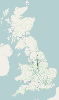
The A61 is a major trunk road in England connecting Derby and Thirsk in North Yorkshire by way of Alfreton, Clay Cross, Chesterfield, Sheffield, Barnsley, Wakefield, Leeds, Harrogate and Ripon. The road is closely paralleled by the M1 motorway between Derby and Leeds.
Contents
1 Route
1.1 Map of Route
2 Road safety
3 References
4 External links
Route

The A61 at the Sheepscar Interchange (its interchange with the A58 and the Leeds Inner Ring Road), in Sheepscar, Leeds.
Heading south, the road begins as single carriageway from Thirsk which bypasses Ripon and travels towards Harrogate, eventually passing through Harrogate town centre. Here, the road divides into two major one-way streets which enclose the town centre and run along The Stray, a 200-acre (0.81 km2) stretch of grassland in Harrogate. As Leeds Road, it then passes through the southern suburbs of Harrogate before meeting the A658 near the village of Pannal. The A61 continues through Harewood before approaching the north's metropolis, where a sudden urban fringe approaches. As the road enters Leeds and crosses the A6120 outer ring road, the road becomes Scott Hall Road, a main dual carriageway (or Trunk Road) and artery for north Leeds. There are sections of guided bus route using kerb guidance near Potternewton. Here, the A61 rises slightly, and a panoramic view of Leeds skyline is revealed. The descent into Leeds is quick and the road soon turns into a multi-lane road, as it approaches Sheepscar Interchange. Fast-flowing traffic is directed onto the A61, although some traffic is directed off the A61 to avoid Leeds City Centre as it routes around the back of Quarry House. The A61 meets it shortly after, as it shares the city centre loop for a short distance. After crossing the river, the road splits again before taking traffic out to the motorways. The road then continues out of Leeds towards Wakefield and Barnsley. South of Barnsley it crosses the M1 at Junction 36 then heads towards Sheffield. Between the M1 at Junction 36 and the Westwood roundabout intersection with the A616, the road is designated as a trunk road under the responsibility of Highways England.

Northwards past Sheffield Wednesday Hillsborough Stadium
The A61 travels into Sheffield through Grenoside and Hillsborough, passing next to the Sheffield Wednesday football stadium. At this point it forms a major artery into the City Centre from the north, before becoming the Sheffield Inner Ring Road (which as of 2007 is labelled as A61 all the way around). It meets the A57 twice; at Park Square and Brookhill roundabout. The A61 takes a southerly course past Sheffield United football stadium through Heeley as Chesterfield Road and climbs up to Norton and Greenhill roundabout. Between Sheffield and Chesterfield is a dual carriageway, avoids Dronfield as the eponymous by-pass. The road used to go through Chesterfield town centre, passing by the famous crooked spire, but was heavily congested. This was alleviated by the construction of the Chesterfield bypass in the 1980s on the alignment of the former Great Central Railway. The road reverts to single carriageway south of Chesterfield, passing through Clay Cross and Alfreton.

Southwards past Chesterfield
South of Alfreton, the A61 merges with the dual carriageway A38, but the old A61 continues as the B6179 through Swanwick and Denby, meeting the A38 again just north of the City. The A61 road continues towards the city centre along Sir Frank Whittle Road until it finally ends at the junction with the A52 near to the headquarters of Derbyshire County Cricket Club.
Map of Route
- Route of A61 overlaid on Google Maps
Road safety
In June 2008 a 6.2-mile (10.0 km) stretch of the A61 between Barnsley and Wakefield was named as the most dangerous road in Britain, when motorcycle accidents were excluded.[1] In the latest EuroRAP findings from the Road Safety Foundation, this stretch of road was also found to be the most dangerous road in Yorkshire and Humber. With 22 fatal and serious injury accidents in the three years analysed (2004–2006), this single carriageway route was rated as Red — the second highest risk category.[2]
References
^
"EuroRAP 2008: GB Tracking Survey Results" (PDF). EuroRAP. 30 June 2008. Archived from the original (PDF) on 10 February 2012. Retrieved 2009-03-09..mw-parser-output cite.citation{font-style:inherit}.mw-parser-output q{quotes:"""""""'""'"}.mw-parser-output code.cs1-code{color:inherit;background:inherit;border:inherit;padding:inherit}.mw-parser-output .cs1-lock-free a{background:url("//upload.wikimedia.org/wikipedia/commons/thumb/6/65/Lock-green.svg/9px-Lock-green.svg.png")no-repeat;background-position:right .1em center}.mw-parser-output .cs1-lock-limited a,.mw-parser-output .cs1-lock-registration a{background:url("//upload.wikimedia.org/wikipedia/commons/thumb/d/d6/Lock-gray-alt-2.svg/9px-Lock-gray-alt-2.svg.png")no-repeat;background-position:right .1em center}.mw-parser-output .cs1-lock-subscription a{background:url("//upload.wikimedia.org/wikipedia/commons/thumb/a/aa/Lock-red-alt-2.svg/9px-Lock-red-alt-2.svg.png")no-repeat;background-position:right .1em center}.mw-parser-output .cs1-subscription,.mw-parser-output .cs1-registration{color:#555}.mw-parser-output .cs1-subscription span,.mw-parser-output .cs1-registration span{border-bottom:1px dotted;cursor:help}.mw-parser-output .cs1-hidden-error{display:none;font-size:100%}.mw-parser-output .cs1-visible-error{font-size:100%}.mw-parser-output .cs1-subscription,.mw-parser-output .cs1-registration,.mw-parser-output .cs1-format{font-size:95%}.mw-parser-output .cs1-kern-left,.mw-parser-output .cs1-kern-wl-left{padding-left:0.2em}.mw-parser-output .cs1-kern-right,.mw-parser-output .cs1-kern-wl-right{padding-right:0.2em}
^
"GB A61 (Risk Rate)". EuroRAP. Archived from the original on 17 February 2012. Retrieved 2009-03-09.
External links
| Wikimedia Commons has media related to A61 road (England). |
- UK roads: A61
- EuroRAP GB Tracking Survey Results
- Road Safety Foundation
A roads in Zone 6 of the Great Britain road numbering scheme | ||
|---|---|---|
| ||
| ||
| ||
| ||
Coordinates: 53°34′02″N 1°28′19″W / 53.56713°N 1.47182°W / 53.56713; -1.47182


