Shau Kei Wan Road
筲箕灣道 | |
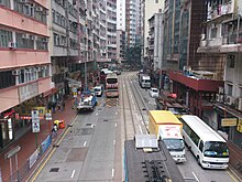 Shau Kei Wan Road near Chai Wan Road in Shau Kei Wan in 2013 | |
| Location | Hong Kong |
|---|---|
| Construction | |
| Inauguration | 1935 |

Shau Kei Wan Road near Holy Cross Path in Sai Wan Ho.
Shau Kei Wan Road (traditional Chinese: 筲箕灣道; simplified Chinese: 筲箕湾道; pinyin: Shāojīwān Dào; Cantonese Yale: saau1 gei1 waan1 dou6), formerly known as Shaukiwan Road, is the main road in Shau Kei Wan and Sai Wan Ho, Hong Kong.
Contents
1 History
2 Features
3 See also
4 References
5 External links
History
The road was originally a main road lying on the north coast of Hong Kong Island from Causeway Bay to Shau Kei Wan, passing through North Point, Tsat Tsz Mui and Quarry Bay.[1]
In 1935,[2] the section between the east end of Causeway Road in Causeway Bay and Tai Kat Street near the East Gate of Taikoo Dockyard (present-day Taikoo Shing) was renamed to King's Road for the silver jubilee of the ascendent of George V of the United Kingdom. At the same time, the section from the junction of Causeway Road and King's Road to Power Street was renamed as Electric Road while the section between King's Road and Electric Road was renamed Tung Lo Wan Road.
Features
The road is shared by Hong Kong Tramways all the way until it reaches Shau Kei Wan Main Street East.
See also
- List of streets and roads in Hong Kong
References
^ Cheng, Po Hung (2005). Early Hong Kong Tramways. Hong Kong University Press. p. 171. ISBN 9628038397..mw-parser-output cite.citation{font-style:inherit}.mw-parser-output .citation q{quotes:"""""""'""'"}.mw-parser-output .citation .cs1-lock-free a{background:url("//upload.wikimedia.org/wikipedia/commons/thumb/6/65/Lock-green.svg/9px-Lock-green.svg.png")no-repeat;background-position:right .1em center}.mw-parser-output .citation .cs1-lock-limited a,.mw-parser-output .citation .cs1-lock-registration a{background:url("//upload.wikimedia.org/wikipedia/commons/thumb/d/d6/Lock-gray-alt-2.svg/9px-Lock-gray-alt-2.svg.png")no-repeat;background-position:right .1em center}.mw-parser-output .citation .cs1-lock-subscription a{background:url("//upload.wikimedia.org/wikipedia/commons/thumb/a/aa/Lock-red-alt-2.svg/9px-Lock-red-alt-2.svg.png")no-repeat;background-position:right .1em center}.mw-parser-output .cs1-subscription,.mw-parser-output .cs1-registration{color:#555}.mw-parser-output .cs1-subscription span,.mw-parser-output .cs1-registration span{border-bottom:1px dotted;cursor:help}.mw-parser-output .cs1-ws-icon a{background:url("//upload.wikimedia.org/wikipedia/commons/thumb/4/4c/Wikisource-logo.svg/12px-Wikisource-logo.svg.png")no-repeat;background-position:right .1em center}.mw-parser-output code.cs1-code{color:inherit;background:inherit;border:inherit;padding:inherit}.mw-parser-output .cs1-hidden-error{display:none;font-size:100%}.mw-parser-output .cs1-visible-error{font-size:100%}.mw-parser-output .cs1-maint{display:none;color:#33aa33;margin-left:0.3em}.mw-parser-output .cs1-subscription,.mw-parser-output .cs1-registration,.mw-parser-output .cs1-format{font-size:95%}.mw-parser-output .cs1-kern-left,.mw-parser-output .cs1-kern-wl-left{padding-left:0.2em}.mw-parser-output .cs1-kern-right,.mw-parser-output .cs1-kern-wl-right{padding-right:0.2em}
^ Yanne, Andrew; Heller, Gillis (2009). Signs of a Colonial Era. Hong Kong University Press. pp. 15, 126. ISBN 9789622099449.
External links
| Wikimedia Commons has media related to Shau Kei Wan Road. |
- Google Maps of Shau Kei Wan Road
Streets and roads on Hong Kong Island | |
|---|---|
| Central and Western District |
|
| Wan Chai District |
|
| Eastern District |
|
| Southern District |
|
| Spans more than one district |
|
| |
Coordinates: 22°16′45″N 114°13′34″E / 22.27927°N 114.22612°E / 22.27927; 114.22612
This Hong Kong road article is a stub. You can help Wikipedia by expanding it. |


