Steinsel
Steinsel Steesel | ||
|---|---|---|
Commune | ||
 | ||
| ||
 Map of Luxembourg with Steinsel highlighted in orange, and the canton in dark red | ||
| Coordinates: 49°40′35″N 6°07′25″E / 49.6764°N 6.1236°E / 49.6764; 6.1236Coordinates: 49°40′35″N 6°07′25″E / 49.6764°N 6.1236°E / 49.6764; 6.1236 | ||
| Country | ||
| Canton | Luxembourg | |
| Government | ||
| • Mayor | Jean-Pierre Klein | |
| Area | ||
| • Total | 21.81 km2 (8.42 sq mi) | |
| Area rank | 46 of 102 | |
| Highest elevation | 373 m (1,224 ft) | |
| • Rank | 74th of 102 | |
| Lowest elevation | 241 m (791 ft) | |
| • Rank | 49th of 102 | |
| Population (2014) | ||
| • Total | 4,921 | |
| • Rank | 27th of 102 | |
| • Density | 230/km2 (580/sq mi) | |
| • Density rank | 30th of 102 | |
| Time zone | UTC+1 (CET) | |
| • Summer (DST) | UTC+2 (CEST) | |
| LAU 2 | LU00011008 | |
| Website | steinsel.lu | |

Steinsel (Luxembourgish: Steesel) is a commune and town in central Luxembourg. It is located north of Luxembourg City.
As of 2005[update], the town of Steinsel, which lies in the west of the commune, has a population of 1,844. Other towns within the commune include Heisdorf and Mullendorf.

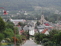
The church of Steinsel
Twin town
 Pacé, France
External links
 Media related to Steinsel at Wikimedia Commons
Places adjacent to Steinsel | ||||||||||
|---|---|---|---|---|---|---|---|---|---|---|
| ||||||||||
Communes of Luxembourg | ||
|---|---|---|
|  | |
This article related to the geography of Luxembourg canton is a stub. You can help Wikipedia by expanding it. |


