Kitimat Ranges
| Kitimat Ranges | |
|---|---|
 Kitimat Ranges as defined in S. Holland Landforms of British Columbia | |
| Elevation | 2,759 metres (9,052 ft) |
| Dimensions | |
| Area | 62,777 km2 (24,238 sq mi) |
| Geography | |
| Country | Canada |
| Province | British Columbia |
| Range coordinates | 53°50′N 128°30′W / 53.833°N 128.500°W / 53.833; -128.500Coordinates: 53°50′N 128°30′W / 53.833°N 128.500°W / 53.833; -128.500 |
| Parent range | Coast Mountains |
The Kitimat Ranges are one of the three main subdivisions of the Coast Mountains in British Columbia, Canada, the others being the Pacific Ranges to the south and the Boundary Ranges to the north.
Contents
1 Geography
2 Sub-ranges
3 Parks
4 Rivers
5 See also
6 References
Geography

The Kitimat Ranges, rising behind Kitimat, British Columbia
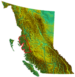
The Kitimat Ranges lie between the Nass River and Portland Inlet in the north[1] and the Bella Coola River and Burke Channel on the south, and are bounded on their east by the Hazelton Mountains and include the mountainous islands of the North Coastal Archipelago, as well as King Island, which lies between Dean Channel and the aforesaid Burke Channel. Some of those islands are part of a separate formation known as the Coastal Trough.[2][3]
Although lower than the neighbouring Pacific Ranges to the south, they are in some ways more rugged, and are heavily indented by coastal inlets as well as by fjord-like lake valleys on the Interior side of the range.
Sub-ranges
- Bare Top Range
- Countess of Dufferin Range
- Kitlope Range
North Coastal Archipelago
- Bell Range
- Burnaby Range
- Cape Range
- Chismore Range
- Murphy Range
- Richardson Range
- Spiller Range
- Williams Range
- Wimbledon Range
- Tenaiko Range
Parks
- Tweedsmuir South Provincial Park
- Tweedsmuir North Provincial Park and Protected Area
- Kitimat River Provincial Park
- Kleanza Creek Provincial Park
- Khutzeymateen Grizzly Bear Sanctuary
- Nisga'a Memorial Lava Beds Provincial Park
- Kitlope Heritage Conservancy
Rivers
Rivers within or originating in, or which transit the Kitimat Ranges, are:
- Brim River
- Dean River
- Kemano River
- Kitimat River
- Kitlope River
See also
- Mountain ranges of British Columbia
- North American Cordillera
References
^ BC Names/GeoBC entry "Kitimat Ranges"
^ S. Holland, Landforms of British Columbia, Province of British Columbia, 1976, p. 41
^ Map from Bulletin 48: Landforms of British Columbia
.mw-parser-output .navbox-canada .navbox-title,.mw-parser-output .navbox-canada th,.mw-parser-output .navbox-canada .navbox-group,.mw-parser-output .navbox-canada .navbox-abovebelow,.mw-parser-output .navbox-canada .navbox-subgroup,.mw-parser-output .navbox-canada .navbox-odd,.mw-parser-output .navbox-canada .navbox-even{background-color:white}.mw-parser-output .navbox-canada .navbox-list .collapsible .navbox-title{box-shadow:inset 1px 1px 0 #C00,inset -1px -1px 0 #C00}.mw-parser-output .navbox-canada-a{box-shadow:inset 1px 1px 0 #C00,inset -1px -1px 0 #C00}.mw-parser-output .navbox-canada-t{box-shadow:inset 0 1px 0 0 #C00}.mw-parser-output .navbox-canada-b{box-shadow:inset 0 -1px 0 0 #C00}.mw-parser-output .navbox-canada-tb{box-shadow:inset 0 1px 0 0 #C00,inset 0 -1px 0 0 #C00} | |
|---|---|
| Ranges |
|
| Mountains |
|
| Communities |
|
| Parks |
|
This article about a location on the Coast of British Columbia, Canada is a stub. You can help Wikipedia by expanding it. |


