Portal:Geography of Canada
Portal:Geography of Canada
Jump to navigation
Jump to search
Portal maintenance status: (June 2018)
Please take care when editing, especially if using automated editing software. Learn how to update the maintenance information here. |
The Geography of Canada Portal
Introduction -

The geography of Canada describes the geographic features of Canada, the world's second largest country in total area.
Situated in northern North America (constituting 41% of the continent's area), Canada spans a vast, diverse territory between the North Pacific Ocean to the west and the North Atlantic Ocean to the east and the Arctic Ocean to the north (hence the country's motto "From sea to sea"), with the United States to the south (contiguous United States) and northwest (Alaska). Greenland is to the northeast; off the southern coast of Newfoundland lies Saint-Pierre and Miquelon, an overseas collectivity of France. Since 1925, Canada has claimed the portion of the Arctic between 60°W and 141°W longitude to the North Pole; however, this claim is contested. While the magnetic North Pole lies within the Canadian Arctic territorial claim as of 2011, recent measurements indicate it is moving towards Siberia.
Selected article -

No damages or casualties resulted from the Nazko earthquakes, which were too small to be felt by people, but local seismographs recorded them. The earthquake swarm occurred at the eastern end of a known volcanic zone called the Anahim Volcanic Belt. This is an east-west trending 600 km (370 mi) long line of volcanoes that extends from just north of Vancouver Island to near the small city of Quesnel.
Read more...
Selected region -
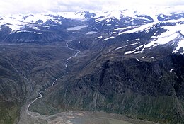
The range is mostly located in Nunavut but extends southeast into the northernmost tip of Labrador and northeastern Quebec. The system is divided into a series of ranges, with mountains reaching heights more than 2,000 m (6,562 ft). The highest of the group is Barbeau Peak on Ellesmere Island at 2,616 m (8,583 ft), which is the highest point in eastern North America. The system is also one of Canada's three mountain systems, the others being the Western Cordillera of Western Canada and the Canadian extension of the Appalachian Mountains into the Gaspe Peninsula and Atlantic Provinces.
Read more...
Selected fauna -
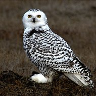
Until recently, it was regarded as the sole member of a distinct genus, as Nyctea scandiaca, but mtDNA cytochrome b sequence data (Olsen et al. 2002) shows that it is very closely related to the horned owls in the genus Bubo. The Snowy Owl is the official bird of Quebec. This species of owl nests on the ground, building a scrape on top of a mound or boulder. A site with good visibility, ready access to hunting areas, and a lack of snow is chosen. Gravel bars and abandoned eagle nests may be used. Breeding occurs in May, and depending on the amount of prey available, clutch sizes range from 5 to 14 eggs, which are laid singly, approximately every other day over the course of several days.
Read more..
Selected images -
.mw-parser-output div.randomSlideshow-container>ul.gallery.mw-gallery-slideshow>li.gallerycarousel>div>div>div>span:nth-child(2){display:none}@media screen and (max-width:720px){.mw-parser-output div.randomSlideshow-container>ul.gallery.mw-gallery-slideshow>li:nth-child(n/**/+5){display:none}.mw-parser-output div.randomSlideshow-container>ul.gallery.mw-gallery-slideshow{padding-left:0;padding-right:0;display:flex;flex-wrap:wrap;justify-content:space-around;align-items:flex-start}.mw-parser-output div.randomSlideshow-container>ul.gallery.mw-gallery-slideshow>li{width:initial!important;margin:0 0.5em}.mw-parser-output div.randomSlideshow-container>ul.gallery.mw-gallery-slideshow>li>div>div>div{margin:0.5em 0!important}}
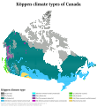
Köppen climate classification types of Canada

Arctic tundra covers parts of extreme northern Canada.

The Horseshoe Falls in Niagara Falls, Ontario, one of the world's most voluminous waterfalls, a major source of hydroelectric power, and a tourist destination.


Did you know? -
- ...that the St. Eugene Mine in Moyie, British Columbia produced ten million dollars' worth of ore between 1895 and 1905 and was considered to be the most important silver–lead mine in Canada? Read More...
Selected National Park -

Pingos in Pingo National Landmark
Pingo National Landmark is a natural area protecting eight pingos near Tuktoyaktuk, Northwest Territories. It is in a coastal region of the Arctic Ocean which contains approximately 1,350 Arctic ice dome hills—approximately one quarter of the world's pingos.
The Landmark comprises an area roughly 16 km2 (6.2 sq mi), just 5 km (3.1 mi) west of Tuktoyaktuk, and includes Ibyuk pingo, Canada's highest (and the world's second-highest), at 49 m (161 ft). The Landmark is managed by Parks Canada under the National Parks Act. Although a nationwide Landmarks program was envisioned at its creation, Pingo remains the country's only National Landmark.
In a region near the Beaufort Sea which is quite flat, pingos dominate the skyline, rising from 5 to 36 m (16 to 118 ft), in various stages of growth and collapse. Ibyuk pingo, the highest, continues to grow about 2 cm (0.79 in) per year, and is estimated to be at least 1,000 years old. Unique to areas of permafrost, pingos have formed here thanks to numerous lakes in the Tuktoyaktuk Peninsula.
Read more...
Selected flora -
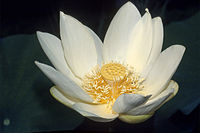
Nelumbo lutea is a species of flowering plant of the order Proteales that is native to North America. - American Lotus, Yellow Lotus, and Water-chinquapin.
Like the Asian species Nelumbo nucifera, the Lotus is an emergent aquatic plant. It grows in lakes and swamps, as well as areas subject to flooding. The roots are anchored in the mud, but the leaves and flowers emerge above the water's surface. The petioles of the leaves may extend as much as 2 m (6.6 ft) and end in a round leaf blade 33–43 cm (13–17 in) in diameter. Mature plants range in height from 0.8 to 1.5 m (2.6 to 4.9 ft).
Read more..
Geography of Canada category
To display all subcategories click on the ►
▼ Geography of Canada ► Northern Canada ► Geography of Canada by census division ► Geography of Canada by city ► Geography of Canada by province or territory ► Geography of Canada by region ► Canada geography-related lists ► Borders of Canada ► Climbing areas of Canada ► Ecoregions of Canada ► First Nations geography ► Forests of Canada ► Geographic regions of Canada ► Glaciology of Canada ► Grasslands of Canada ► Historic sites in Canada ► Historical regions in Canada ► Landforms of Canada ► Landmarks in Canada ► Maps of Canada ► Micronations in Canada ► Military locations of Canada ► Names of places in Canada ► Natural disasters in Canada ► Natural gas fields in Canada ► Paranormal places in Canada ► Parks in Canada ► Ponds of Canada ► Populated places in Canada ► Ports and harbours of Canada ► Real estate in Canada ► Regions of Canada ► Squares in Canada ► Subdivisions of Canada ► Time in Canada ► Volcanism of Canada ► Whaling stations in Canada ► Wine regions of Canada ► Canada geography stubs |
Selected panoramic picture -

View of the far side of Pangnirtung, Nunavut.
Topics
 WikiProject Geography of Canada ... | |||||
| National |
| ||||
|---|---|---|---|---|---|
| Provinces |
| ||||
| Territories |
| ||||
| Geography |
| ||||
| National parks |
| ||||
| National Reserves |
| ||||
| Marine Areas |
| ||||
| Future parks |
| ||||
| World Heritage Sites |
| ||||
| National Trails |
| ||||
Related portals
| Topics | Provinces & Territories | Cities & Regions | |||
|---|---|---|---|---|---|
|
|
| |||
What are Portals? ·
List of Canadian portals
Associated Wikimedia
Purge server cache
![]()
Categories:
- Canadian portals
- Geography of Canada
(window.RLQ=window.RLQ||).push(function(){mw.config.set({"wgPageParseReport":{"limitreport":{"cputime":"0.920","walltime":"1.169","ppvisitednodes":{"value":2712,"limit":1000000},"ppgeneratednodes":{"value":0,"limit":1500000},"postexpandincludesize":{"value":166583,"limit":2097152},"templateargumentsize":{"value":6560,"limit":2097152},"expansiondepth":{"value":17,"limit":40},"expensivefunctioncount":{"value":2,"limit":500},"unstrip-depth":{"value":0,"limit":20},"unstrip-size":{"value":20928,"limit":5000000},"entityaccesscount":{"value":0,"limit":400},"timingprofile":["100.00% 889.034 1 -total"," 47.67% 423.775 1 Template:Transclude_files_as_random_slideshow"," 18.73% 166.545 7 Template:Random_portal_component_with_nominate"," 7.92% 70.446 13 Portal:Geography_of_Canada/box-header/2"," 7.67% 68.211 1 Portal:Canada/Related_portals"," 7.52% 66.880 13 Template:Box-header"," 7.45% 66.232 1 Template:Portal_maintenance_status"," 6.50% 57.751 14 Template:Flagicon"," 5.25% 46.634 6 Portal:Geography_of_Canada/box-header"," 4.98% 44.267 12 Template:Convert"]},"scribunto":{"limitreport-timeusage":{"value":"0.576","limit":"10.000"},"limitreport-memusage":{"value":6006380,"limit":52428800}},"cachereport":{"origin":"mw1318","timestamp":"20190108142233","ttl":21600,"transientcontent":true}}});mw.config.set({"wgBackendResponseTime":108,"wgHostname":"mw1262"});});


