File:Germany adm location map.svg
File:Germany adm location map.svg
Jump to navigation
Jump to search
- File
- File history
- File usage
- Global file usage
- Metadata
Original file (SVG file, nominally 1,073 × 1,272 pixels, file size: 643 KB)
| This is a file from the Wikimedia Commons. Information from its description page there is shown below. Commons is a freely licensed media file repository. You can help. |
Summary
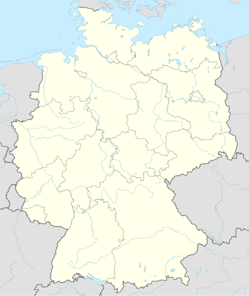
| DescriptionGermany adm location map.svg | Deutsch: Positionskarte von Deutschland English: Location map of Germany
| ||||||||||||
| Date | 15 September 2014 | ||||||||||||
| Source | Own work using:
| ||||||||||||
| Author | NordNordWest | ||||||||||||
| SVG development |
| ||||||||||||

Licensing
Usage of this file with:

Map: NordNordWest, Licence: Creative Commons by-sa-3.0 de
explanatory notes: Legally binding is only the full legalcode. For a free usage I recommend to respect the following licence conditions:
1. Provide my name as given above: NordNordWest,
2. a copy of, or the URI for, the applicable license: https://creativecommons.org/licenses/by-sa/3.0/de/legalcode,
3. the title of the work,
4. in the case of an adaptation, a credit identifying the use of the work in the adaptation.
This license and the rights granted hereunder will terminate automatically upon any breach by you of the terms of this license. Any of the above conditions can be waived if you get permission from the copyright holder. If you have questions or wish differing conditions, please contact me through nnwest or my discussion page ![]() web.de
web.de
| This file is licensed under the Creative Commons Attribution-Share Alike 3.0 Germany license. |  |
| Attribution: Karte: NordNordWest, Lizenz: Creative Commons by-sa-3.0 de | ||
https://creativecommons.org/licenses/by-sa/3.0/de/deed.en |
| This file has been released under a license which is incompatible with Facebook's licensing terms. It is not permitted to upload this file to Facebook. |
File history
Click on a date/time to view the file as it appeared at that time.
| Date/Time | Thumbnail | Dimensions | User | Comment | |
|---|---|---|---|---|---|
| current | 17:46, 15 September 2014 |  | 1,073 × 1,272 (643 KB) | NordNordWest | == {{int:filedesc}} == {{Information |Description= {{de|1=Positionskarte von Deutschland}} {{en|1=Location map of Germany}} {{Location map series N |top=55.1 |bottom=47.2 |left=5.5 |right=15.5 }} |Source={{Own using}} * United States National Imagery a... |
File usage
More than 100 pages use this file.
The following list shows the first 100 pages that use this file only.
A full list is available.
- Aachen
- Aalen
- Abensberg
- Anklam
- Ansbach
- Augsburg
- Bacharach
- Backnang
- Bad Doberan
- Baden-Baden
- Badenweiler
- Bamberg
- Battle of Lützen (1632)
- Battle of Nördlingen (1634)
- Battle of Wittstock
- Bauhaus
- Bayreuth
- Berchtesgaden
- Bonn
- Braunschweig
- Calw
- Cologne
- Cottbus
- DESY
- Dachau
- Darmstadt
- Dresden
- Duisburg
- Düsseldorf
- Eisenach
- Erfurt
- Fehmarn
- Flensburg
- Frankfurt
- Frankfurt (Oder)
- Freiburg im Breisgau
- Friedrichshafen
- Fulda
- German Unity Day
- Greifswald
- Güstrow
- Hanover
- Heide
- Heidelberg
- Hilter
- Husum
- Karlsruhe
- Kassel
- Kiel
- Konstanz
- Landau
- Lauenburg
- Leipzig
- Limburg an der Lahn
- Ludwig Mies van der Rohe
- Ludwigshafen
- Ludwigslust
- Lübeck
- Magdeburg
- Mainz
- Mannheim
- Marburg
- Meissen
- Merseburg
- Munich
- Mölln, Schleswig-Holstein
- Neubrandenburg
- Neustrelitz
- Nuremberg
- Oelde
- Oldenburg
- Osnabrück
- Plön
- Polling, Mühldorf
- Potsdam
- Quedlinburg
- Ramstein Air Base
- Ratzeburg
- Regensburg
- Rendsburg
- Ribnitz-Damgarten
- Rostock
- Rügen
- Saarbrücken
- Schleswig, Schleswig-Holstein
- Schwerin
- Stralsund
- Stuttgart
- Tannenberg, Saxony
- Trier
- Tübingen
- Wartburg
- Weimar
- Wernigerode
- Wiesbaden
- Wismar
- Wittenberg
- Worms, Germany
- Wuppertal
- Zschopau
Global file usage
The following other wikis use this file:
- Usage on ar.wikipedia.org
- كأس العالم 2006
- مطار هامبورغ
- بطولة أمم أوروبا 2024
- بوندسليغا 2
- مستخدم:أحمد توفيق/تجربة
- وحدة:Location map/data/Deutschland
- وحدة:Location map/data/Germany
- وحدة:Location map/data/Germany/شرح
- وحدة:Location map/data/Deutschland/شرح
- منطقة بيرشتيسغادنر لاند
- منطقة نويشتادت آن دير آيش - باد فيندسهايم
- الدوري الألماني لكرة القدم 2018–19
- بطولة العالم لكرة اليد للرجال 2019
- Usage on ast.wikipedia.org
- Kiel
- Frankfurt del Main
- Baden-Württemberg
- Baviera
- Berlín
- Munich
- Canal de Kiel
- Hannover
- Hessen
- Neuschwanstein
- Saxonia
- Ríu Elba
- Dresde
- Meißen
- Wiesbaden
- Nymphenburg
- Eschweiler
- Schleswig-Holstein
- Ustersbach
- Allianz Arena
- BayArena
- Rheinfelden (Alemaña)
- Valley (Alemaña)
- Grosselfingen
- Schraden
- Emmendingen
- Irschenberg
- Lübeck
- Münster
- Brandemburgu
- Gotinga
- Puerta de Brandeburgo
- Muru de Berlín
- Essen
- Bochum
- Dortmund
- Wuppertal
View more global usage of this file.
Metadata
(window.RLQ=window.RLQ||).push(function(){mw.config.set({"wgBackendResponseTime":214,"wgHostname":"mw1244"});});


