Phetchaburi
Phetchaburi เพชรบุรี | |
|---|---|
Town | |
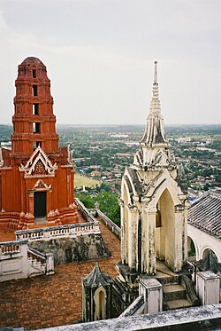 Picture taken from atop Khao Wang, in the palace compound, looking down on Phetchaburi | |
 Location in Phetchaburi Province | |
| Country | Thailand |
| Province | Phetchaburi Province |
| Area | |
| • Total | 5.4 km2 (2.1 sq mi) |
| Population (2005) | |
| • Total | 26,181 |
| • Density | 4,800/km2 (13,000/sq mi) |
| Time zone | UTC+7 (ICT) |
Phetchaburi (Thai: เพชรบุรี, pronounced [pʰét.t͡ɕʰā.bū.rīː]) or Phet Buri (pronounced [pʰét bū.rīː]) is a town (thesaban mueang) in southern Thailand, capital of Phetchaburi Province. In Thai, Phetchaburi means "city of diamonds" (buri meaning "city" in sanskrit). It is approximately 160 km south of Bangkok, at the northern end of the Thai peninsula. As of 2005, the town had a population of 26,181 and covers the two tambon Tha Rap and Khlong Krachaeng.[1]
The Phetchaburi River runs through the middle of the city. The region is mostly flat, save for a single hill (called Khao Wang) on the outskirts of town. The royal palace named Phra Nakhon Khiri and one of the many wats are on top of Khao Wang. The hill and town is the site of an annual festival, called the Phra Nakhon Khiri Fair. It lasts for eight days in early February and includes a sound and light show and classical Thai dance.
The official city flower is the leelowadee flower or frangipani.
Phetchaburi is known for its traditional Thai desserts. The most well-known is a custard dessert called khanom mor gaeng. Other popular desserts include Portuguese-influenced thong yip, thong yod, and foi thong.
Contents
1 Climate
2 Education
3 Transportation
4 References
5 External links
Climate
| Climate data for Phetchaburi (1981–2010) | |||||||||||||
|---|---|---|---|---|---|---|---|---|---|---|---|---|---|
| Month | Jan | Feb | Mar | Apr | May | Jun | Jul | Aug | Sep | Oct | Nov | Dec | Year |
| Record high °C (°F) | 35.0 (95.0) | 35.2 (95.4) | 36.6 (97.9) | 37.8 (100.0) | 38.5 (101.3) | 37.2 (99.0) | 38.1 (100.6) | 37.5 (99.5) | 37.5 (99.5) | 35.7 (96.3) | 35.7 (96.3) | 35.1 (95.2) | 38.5 (101.3) |
| Average high °C (°F) | 30.4 (86.7) | 31.1 (88.0) | 32.1 (89.8) | 33.3 (91.9) | 33.4 (92.1) | 32.9 (91.2) | 32.6 (90.7) | 32.6 (90.7) | 32.2 (90.0) | 31.5 (88.7) | 31.1 (88.0) | 30.5 (86.9) | 32.0 (89.6) |
| Daily mean °C (°F) | 25.8 (78.4) | 27.2 (81.0) | 28.5 (83.3) | 29.7 (85.5) | 29.4 (84.9) | 29.0 (84.2) | 28.7 (83.7) | 28.6 (83.5) | 28.2 (82.8) | 27.7 (81.9) | 26.9 (80.4) | 25.4 (77.7) | 27.9 (82.2) |
| Average low °C (°F) | 21.2 (70.2) | 23.1 (73.6) | 24.8 (76.6) | 25.8 (78.4) | 26.0 (78.8) | 25.9 (78.6) | 25.6 (78.1) | 25.6 (78.1) | 25.1 (77.2) | 24.6 (76.3) | 23.3 (73.9) | 21.0 (69.8) | 24.3 (75.7) |
| Record low °C (°F) | 14.0 (57.2) | 16.0 (60.8) | 16.0 (60.8) | 21.8 (71.2) | 23.0 (73.4) | 22.9 (73.2) | 21.0 (69.8) | 23.0 (73.4) | 21.6 (70.9) | 18.5 (65.3) | 15.6 (60.1) | 12.4 (54.3) | 12.4 (54.3) |
| Average rainfall mm (inches) | 11.4 (0.45) | 3.9 (0.15) | 33.1 (1.30) | 36.9 (1.45) | 99.5 (3.92) | 92.0 (3.62) | 80.8 (3.18) | 92.3 (3.63) | 153.6 (6.05) | 278.4 (10.96) | 93.8 (3.69) | 11.6 (0.46) | 987.3 (38.87) |
| Average rainy days | 1.1 | 1.1 | 2.7 | 3.9 | 11.1 | 12.9 | 14.1 | 15.5 | 16.5 | 16.9 | 6.4 | 1.4 | 103.6 |
| Average relative humidity (%) | 74 | 77 | 77 | 76 | 76 | 76 | 76 | 76 | 80 | 82 | 77 | 72 | 77 |
| Mean monthly sunshine hours | 229.4 | 211.9 | 238.7 | 204.0 | 155.0 | 114.0 | 117.8 | 58.9 | 108.0 | 108.5 | 171.0 | 226.3 | 1,943.5 |
| Mean daily sunshine hours | 7.4 | 7.5 | 7.7 | 6.8 | 5.0 | 3.8 | 3.8 | 1.9 | 3.6 | 3.5 | 5.7 | 7.3 | 5.3 |
| Source #1: Thai Meteorological Department[2] | |||||||||||||
| Source #2: Office of Water Management and Hydrology, Royal Irrigation Department (sun and humidity)[3] | |||||||||||||
Education
Phetchaburi has numerous private and public schools from K-12. Several have English programs taught by native English speakers to ready students for higher education. Some of the schools are Benchamatheputhit School, Prommanusorn School, Benjamaputit Mattayom School, Wat Don Kaitia Prathom School, and Arunpradit Prathom/Mattayom School. There are also several universities, including Phetchaburi Ratchabat University.
Transportation
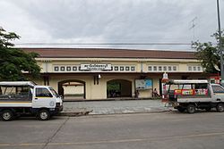
Phetchaburi Railway Station
In the city proper, the primary mode of transportation is by motor vehicle with motorbikes being the most popular. Cars are the second major form of transportation. Locals also travel by hired motorcycles and songthaews.
References
^ Department of provincial administration Archived August 5, 2012, at the Wayback Machine
^ "Climatological Data for the Period 1981–2010". Thai Meteorological Department. p. 21–22. Retrieved 6 August 2016..mw-parser-output cite.citation{font-style:inherit}.mw-parser-output .citation q{quotes:"""""""'""'"}.mw-parser-output .citation .cs1-lock-free a{background:url("//upload.wikimedia.org/wikipedia/commons/thumb/6/65/Lock-green.svg/9px-Lock-green.svg.png")no-repeat;background-position:right .1em center}.mw-parser-output .citation .cs1-lock-limited a,.mw-parser-output .citation .cs1-lock-registration a{background:url("//upload.wikimedia.org/wikipedia/commons/thumb/d/d6/Lock-gray-alt-2.svg/9px-Lock-gray-alt-2.svg.png")no-repeat;background-position:right .1em center}.mw-parser-output .citation .cs1-lock-subscription a{background:url("//upload.wikimedia.org/wikipedia/commons/thumb/a/aa/Lock-red-alt-2.svg/9px-Lock-red-alt-2.svg.png")no-repeat;background-position:right .1em center}.mw-parser-output .cs1-subscription,.mw-parser-output .cs1-registration{color:#555}.mw-parser-output .cs1-subscription span,.mw-parser-output .cs1-registration span{border-bottom:1px dotted;cursor:help}.mw-parser-output .cs1-ws-icon a{background:url("//upload.wikimedia.org/wikipedia/commons/thumb/4/4c/Wikisource-logo.svg/12px-Wikisource-logo.svg.png")no-repeat;background-position:right .1em center}.mw-parser-output code.cs1-code{color:inherit;background:inherit;border:inherit;padding:inherit}.mw-parser-output .cs1-hidden-error{display:none;font-size:100%}.mw-parser-output .cs1-visible-error{font-size:100%}.mw-parser-output .cs1-maint{display:none;color:#33aa33;margin-left:0.3em}.mw-parser-output .cs1-subscription,.mw-parser-output .cs1-registration,.mw-parser-output .cs1-format{font-size:95%}.mw-parser-output .cs1-kern-left,.mw-parser-output .cs1-kern-wl-left{padding-left:0.2em}.mw-parser-output .cs1-kern-right,.mw-parser-output .cs1-kern-wl-right{padding-right:0.2em}
^ "ปริมาณการใช้น้ำของพืชอ้างอิงโดยวิธีของ Penman Monteith (Reference Crop Evapotranspiration by Penman Monteith)" (PDF) (in Thai). Office of Water Management and Hydrology, Royal Irrigation Department. p. 83. Retrieved 6 August 2016.
External links
 Phetchaburi travel guide from Wikivoyage
- Kaeng Krachan National Park, Phetchaburi
Coordinates: 13°06′43″N 99°56′45″E / 13.11194°N 99.94583°E / 13.11194; 99.94583
Capitals of provinces of Thailand | ||
|---|---|---|
| ||
Authority control |
|
|---|


