Vestnes
Vestnes
Jump to navigation
Jump to search
Vestnes kommune | |||
|---|---|---|---|
Municipality | |||
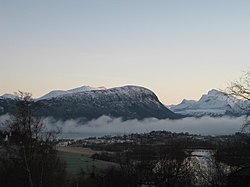
 View of Vestnes with mountains in the background | |||
| |||
 Vestnes within Møre og Romsdal | |||
| Coordinates: 62°35′04″N 07°01′06″E / 62.58444°N 7.01833°E / 62.58444; 7.01833Coordinates: 62°35′04″N 07°01′06″E / 62.58444°N 7.01833°E / 62.58444; 7.01833 | |||
| Country | Norway | ||
| County | Møre og Romsdal | ||
| District | Romsdal | ||
| Administrative centre | Vestnes | ||
| Government | |||
| • Mayor (2011) | Geir Inge Lien (Sp) | ||
| Area | |||
| • Total | 352.02 km2 (135.92 sq mi) | ||
| • Land | 347.50 km2 (134.17 sq mi) | ||
| • Water | 4.52 km2 (1.75 sq mi) | ||
| Area rank | #257 in Norway | ||
| Population (2017) | |||
| • Total | 6,577 | ||
| • Rank | #160 in Norway | ||
| • Density | 18.9/km2 (49/sq mi) | ||
| • Change (10 years) | 2.7% | ||
| Demonym(s) | Vestnesing[1] | ||
| Time zone | UTC+01:00 (CET) | ||
| • Summer (DST) | UTC+02:00 (CEST) | ||
| ISO 3166 code | NO-1535 | ||
| Official language form | Nynorsk | ||
| Website | www.vestnes.kommune.no | ||
Data from Statistics Norway | |||
Vestnes is a municipality in Møre og Romsdal county, Norway. Vestnes is part of the traditional district of Romsdal. The administrative centre of the municipality is the village of Vestnes. Other villages in the municipality include Vikebukt, Vik, Øverås, Fiksdal, Tomrefjord, and Tresfjord.
The area is known for nature and outdoor pursuits, and has a long history in ship building and maritime crafts. The village of Vestnes (Helland) dates back to early medieval times, and has 24-hour ferry and water taxi service with the town of Molde to the northeast. The ferry takes about 35-minutes each way.
The 352-square-kilometre (136 sq mi) municipality is the 257th largest by area out of the 422 municipalities in Norway. Vestnes is the 160th most populous municipality in Norway with a population of 6,577. The municipality's population density is 18.9 inhabitants per square kilometre (49/sq mi) and its population has increased by 2.7% over the last decade.[2]
Contents
1 General information
1.1 Name
1.2 Coat-of-arms
1.3 Museums
1.4 Churches
2 Geography
3 Government
3.1 Municipal council
4 Economy
5 Media
6 Transportation
7 Notable residents
8 References
9 External links
General information[edit]

Map of Vestnes

View of the Tresfjord Church

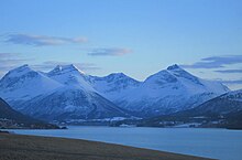
View of the Tresfjorden
The municipality of Vestnes was established in the fall of 1838 when the western district of the large Veøy Municipality was separated to form its own municipality (see formannskapsdistrikt). On 1 January 1899, the southern district of Tresfjord (population: 1,408) was separated from Vestnes to form its own municipality, but it was merged back into Vestnes on 1 January 1964.[3]
Name[edit]
The municipality (originally the parish) is named after the old Vestnes farm (Old Norse: Vestnes), since the first Vestnes Church was built there. The first element is vestr which means "west" and the last element is nes which means "headland". Before 1889, the name was written Vestnæs.[4]
Coat-of-arms[edit]
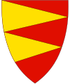
The coat-of-arms is from modern times. They were granted on 11 April 1980. The arms have a red background with two triangular gold spikes pointing right. The arms represent the geography of the municipality: a headland between two fjords—the Tresfjorden and the Tomrefjorden.[5]
Museums[edit]
The Møre og Romsdal Agricultural Museum (Landbruksmuseet for Møre og Romsdal) was established in the municipality at the Gjermundnes Farm in 1979.[6][7]
Churches[edit]
The Church of Norway has four parishes (sokn) within the municipality of Vestnes. It is part of the Indre Romsdal deanery in the Diocese of Møre.
| Parish (Sokn) | Church Name | Location of the Church | Year Built |
|---|---|---|---|
| Vestnes | Vestnes Church | Vestnes | 1872 |
| Fiksdal | Fiksdal Church | Fiksdal | 1866 |
| Tresfjord | Tresfjord Church | Tresfjord | 1828 |
| Vike | Vike Church | Vikebukt | 1970 |
Geography[edit]
Vestnes is located in an area of great natural splendour on the southern shores of Romsdal Fjord. The Tresfjorden and Tomrefjorden branch off Romsdal Fjord to the south. Vestnes borders Rauma Municipality to the east, as well as Stordal Municipality and Ørskog Municipality to the south. Across the Moldefjorden to the north is Midsund Municipality and Molde Municipality.

view of Fiksdal village
Government[edit]
All municipalities in Norway, including Vestnes, are responsible for primary education (through 10th grade), outpatient health services, senior citizen services, unemployment and other social services, zoning, economic development, and municipal roads. The municipality is governed by a municipal council of elected representatives, which in turn elect a mayor.
Municipal council[edit]
The municipal council (Kommunestyre) of Vestnes is made up of 23 representatives that are elected to four year terms. Currently, the party breakdown is as follows:[8]
| Party Name | Name in Norwegian | Number of representatives | |
|---|---|---|---|
| Labour Party | Arbeiderpartiet | 3 | |
| Progress Party | Framstegspartiet | 2 | |
| Conservative Party | Høgre | 3 | |
| Christian Democratic Party | Kristelig Folkeparti | 1 | |
| Pensioners' Party | Pensjonistpartiet | 1 | |
| Centre Party | Senterpartiet | 10 | |
| Socialist Left Party | Sosialistisk Venstreparti | 1 | |
| Liberal Party | Venstre | 2 | |
| Total number of members: | 23 | ||
Economy[edit]
Vestnes is a relatively good agricultural community with emphasis on livestock and milk production. Vestnes, however, is primarily a manufacturing district. The main industry is the ship-building industry with a number of different companies located in Vestnes. A total of 63% of industry employment (2004) in Vestnes is part of the ship-building industry. Other that shipbuilding, there are several companies in the food, textile and clothing, wood products, furniture, and metal products industries in Vestnes.[5]
Media[edit]
The newspaper Vestnesavisa is published in Vestnes.[9]
Transportation[edit]
The European route E39 highway goes through Vestnes on its way from Sjøholt to Molde. The European route E136 highway goes through Vestnes on its way from Ålesund to Dombås. The two highways intersect and share part of the route through Vestnes. The new Tresfjord Bridge is under construction and will be opened to traffic on 24 October 2015. It will carry the E136 highway over the Tresfjorden rather than the current roadway that follows the shoreline all the way around the fjord.
Notable residents[edit]
Mali Furunes (1888–1968)
Bjørn Rune Gjelsten (born 1956), a Norwegian businessman
Bernt Hulsker (born 1977), a Norwegian retired footballer
Sigrun Misund (born 1955), poet and writer
Kjetil Rekdal (born 1968), a Norwegian football manager and a former footballer
Terje Rypdal (born 1947), a Norwegian guitarist and composer
Lars Vistnes (born 1927-2016), a Norwegian plastic surgeon
References[edit]
^ "Navn på steder og personer: Innbyggjarnamn" (in Norwegian). Språkrådet. Retrieved 2015-12-01..mw-parser-output cite.citation{font-style:inherit}.mw-parser-output q{quotes:"""""""'""'"}.mw-parser-output code.cs1-code{color:inherit;background:inherit;border:inherit;padding:inherit}.mw-parser-output .cs1-lock-free a{background:url("//upload.wikimedia.org/wikipedia/commons/thumb/6/65/Lock-green.svg/9px-Lock-green.svg.png")no-repeat;background-position:right .1em center}.mw-parser-output .cs1-lock-limited a,.mw-parser-output .cs1-lock-registration a{background:url("//upload.wikimedia.org/wikipedia/commons/thumb/d/d6/Lock-gray-alt-2.svg/9px-Lock-gray-alt-2.svg.png")no-repeat;background-position:right .1em center}.mw-parser-output .cs1-lock-subscription a{background:url("//upload.wikimedia.org/wikipedia/commons/thumb/a/aa/Lock-red-alt-2.svg/9px-Lock-red-alt-2.svg.png")no-repeat;background-position:right .1em center}.mw-parser-output .cs1-subscription,.mw-parser-output .cs1-registration{color:#555}.mw-parser-output .cs1-subscription span,.mw-parser-output .cs1-registration span{border-bottom:1px dotted;cursor:help}.mw-parser-output .cs1-hidden-error{display:none;font-size:100%}.mw-parser-output .cs1-visible-error{font-size:100%}.mw-parser-output .cs1-subscription,.mw-parser-output .cs1-registration,.mw-parser-output .cs1-format{font-size:95%}.mw-parser-output .cs1-kern-left,.mw-parser-output .cs1-kern-wl-left{padding-left:0.2em}.mw-parser-output .cs1-kern-right,.mw-parser-output .cs1-kern-wl-right{padding-right:0.2em}
^ Statistisk sentralbyrå (2017). "Table: 06913: Population 1 January and population changes during the calendar year (M)" (in Norwegian). Retrieved 2017-10-20.
^ Jukvam, Dag (1999). "Historisk oversikt over endringer i kommune- og fylkesinndelingen" (PDF) (in Norwegian). Statistisk sentralbyrå.
^ Rygh, Oluf (1908). Norske gaardnavne: Romsdals amt (in Norwegian) (13 ed.). Kristiania, Norge: W. C. Fabritius & sønners bogtrikkeri. p. 217.
^ ab Store norske leksikon. "Vestnes" (in Norwegian). Retrieved 2010-10-25.
^ "Landbruksmuseet for Møre og Romsdal, Gjermundnes". Retrieved January 19, 2018.
^ "Gjermundnes" (PDF). Møre og Romsdal fylkeskommune. Vestnes kommune. Retrieved January 19, 2018.
^ "Table: 04813: Members of the local councils, by party/electoral list at the Municipal Council election (M)" (in Norwegian). Statistics Norway. 2015.
^ Smith-Meyer, Trond, ed. (2012-05-12). "VestnesAvisa". Store norske leksikon (in Norwegian). Kunnskapsforlaget. Retrieved 2017-10-20.
External links[edit]
 Møre og Romsdal travel guide from Wikivoyage
Municipal fact sheet from Statistics Norway (in Norwegian)
- Vestnes official web site
Categories:
- Vestnes
- Municipalities of Møre og Romsdal
(window.RLQ=window.RLQ||).push(function(){mw.config.set({"wgPageParseReport":{"limitreport":{"cputime":"0.720","walltime":"0.938","ppvisitednodes":{"value":4819,"limit":1000000},"ppgeneratednodes":{"value":0,"limit":1500000},"postexpandincludesize":{"value":75594,"limit":2097152},"templateargumentsize":{"value":12519,"limit":2097152},"expansiondepth":{"value":24,"limit":40},"expensivefunctioncount":{"value":8,"limit":500},"unstrip-depth":{"value":1,"limit":20},"unstrip-size":{"value":23905,"limit":5000000},"entityaccesscount":{"value":1,"limit":400},"timingprofile":["100.00% 836.842 1 -total"," 38.54% 322.524 1 Template:Infobox_kommune"," 37.55% 314.221 1 Template:Infobox_settlement"," 27.43% 229.508 1 Template:Infobox"," 26.46% 221.445 1 Template:Kommunestyre_table"," 25.68% 214.931 8 Template:Lang"," 17.38% 145.452 1 Template:Reflist"," 13.53% 113.210 7 Template:Cite_web"," 6.05% 50.593 1 Template:About"," 4.88% 40.827 1 Template:Coord"]},"scribunto":{"limitreport-timeusage":{"value":"0.417","limit":"10.000"},"limitreport-memusage":{"value":16382044,"limit":52428800}},"cachereport":{"origin":"mw1326","timestamp":"20181218213233","ttl":1900800,"transientcontent":false}}});});{"@context":"https://schema.org","@type":"Article","name":"Vestnes","url":"https://en.wikipedia.org/wiki/Vestnes","sameAs":"http://www.wikidata.org/entity/Q488060","mainEntity":"http://www.wikidata.org/entity/Q488060","author":{"@type":"Organization","name":"Contributors to Wikimedia projects"},"publisher":{"@type":"Organization","name":"Wikimedia Foundation, Inc.","logo":{"@type":"ImageObject","url":"https://www.wikimedia.org/static/images/wmf-hor-googpub.png"}},"datePublished":"2003-02-02T20:43:32Z","dateModified":"2018-01-30T12:48:25Z","image":"https://upload.wikimedia.org/wikipedia/commons/2/22/Vestnes01.JPG","headline":"municipality in Mu00f8re og Romsdal, Norway"}(window.RLQ=window.RLQ||).push(function(){mw.config.set({"wgBackendResponseTime":110,"wgHostname":"mw1269"});});

