Sanjak of Segedin
This article includes a list of references, related reading or external links, but its sources remain unclear because it lacks inline citations. (November 2012) (Learn how and when to remove this template message) |
| Sanjak of Segedin Segedin Sancağı Szegedi szandzsák Сегедински санџак | |||||
sanjak of the Ottoman Empire | |||||
| |||||
 | |||||
Capital | Segedin (Hungarian: Szeged) | ||||
History | |||||
| • | Established | 16th century | |||
| • | Disestablished | 1699 | |||
Today part of | Serbia, Hungary | ||||
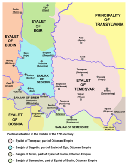
Sanjak of Segedin as part of the Eyalet of Eğri in the middle of the 17th century
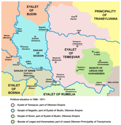
Sanjak of Segedin or Sanjak of Szeged (Turkish: Segedin Sancağı, Hungarian: Szegedi szandzsák, Serbian: Сегедински санџак) was an administrative territorial entity of the Ottoman Empire formed in the 16th century. It was located in the Bačka (Bácska) region. Initially, it was part of the Budin Province, but in the 17th century it was included into Eğri Province. Administrative center of the Sanjak of Segedin was Segedin. It was captured by Austria between 1686-1688 and was left to Austria according to Treaty of Carlowitz in 1699.
Contents
1 Administrative divisions
2 Beys (governors) of the sanjak
3 See also
4 References
5 External links
Administrative divisions
Sanjak of Segedin was divided into several kazas:
Segedin (Szeged)
Sobotka (Subotica)
Baya (Baja)
Sonbor (Sombor)
Baç (Bač)- Titel

Ottoman Sonbor (Sombor) - image from 1698
Beys (governors) of the sanjak
Hasan Pasha Predojević (1592) [1][permanent dead link]
See also
- Subdivisions of the Ottoman Empire
- Bačka
References
- Dr. Dušan J. Popović, Srbi u Vojvodini, knjiga 1, Novi Sad, 1990.
- Istorijski atlas, Geokarta, Beograd, 1999.
External links
- U SUBOTICI ODRŽANA PROMOCIJA PUBLIKACIJE O SEGEDINSKOM SANDŽAKU 1570. GODINE - Kako se živelo pod Turcima
- Map - location of Sanjak of Segedin
- Map of the Sanjak of Segedin
| Wikimedia Commons has media related to Sanjak of Segedin. |
| |
Modern names in parentheses |


