Sogn
| Sogn | |
|---|---|
| District | |
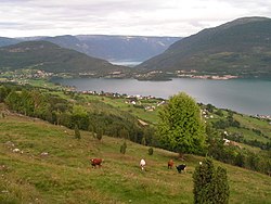 Hafslovatnet with Sognefjord behind | |
 Sogn | |
| Country | Norway |
| County | Sogn og Fjordane |
| Region | Vestlandet |
| Adm. Center | Hermansverk[1] |
| Area | |
| • Total | 10,675 km2 (4,122 sq mi) |
| Population (2006) | |
| • Total | 38,858 |
| • Density | 3.6/km2 (9.4/sq mi) |
| Demonym(s) | Sogning |
Sogn is a traditional district in Western Norway (Vestlandet). It is located in the county of Sogn og Fjordane, surrounding the Sognefjord, the largest/longest fjord in Norway. The district of Sogn consists of the municipalities of Aurland, Balestrand, Hyllestad, Høyanger, Gulen, Leikanger, Luster, Lærdal, Sogndal, Solund, Vik, and Årdal. The district covers 10,675 square kilometres (4,122 sq mi) and contains about 35% of the county's population. The largest urban area in Sogn is the village of Sogndalsfjøra (in Sogndal municipality), with 3,455 residents. The second largest urban area is the village Øvre Årdal (in Årdal municipality), with 3,397 people (this village used to be the largest, but recently it was passed by Sogndalsfjøra).[2][3]
The district of Sogn comprises the southern part of the county Sogn og Fjordane. The districts of Sunnfjord and Nordfjord are the other two districts in the county.
Contents
1 Etymology
2 History
2.1 Viking Age
2.2 1662-present
3 References
Etymology

Shore community in Sogn, Norway.
The name Sogn is very old, and it originally belonged to the fjord (now called the Sognefjord). The name is derived from the verb súga which means "suck"—referring to the strong tidal streams at the mouth of the fjord. A parallel name for the district in Norse times was Sygnafylki. The first element in this name is the genitive of sygnir which means "people from Sogn" and the last element is fylki which is an old form of "fylke" which translates as "county".[1][4]
History

Sogndalsfjorden and Barsnesfjorden.
| Historical population | ||
|---|---|---|
| Year | Pop. | ±% |
| 1769 | 19,366 | — |
| 1951 | 41,846 | +116.1% |
| 1960 | 40,558 | −3.1% |
| 1970 | 40,254 | −0.7% |
| 1980 | 39,689 | −1.4% |
| 1990 | 38,996 | −1.7% |
| 2000 | 37,841 | −3.0% |
| 2010 | 36,511 | −3.5% |
| 2020 | 36,232 | −0.8% |
| 2030 | 36,773 | +1.5% |
| Source: Statistics Norway. | ||
Viking Age
Since early in the Viking Age, Sogn was a petty kingdom called Sygnafylki. Some notable Kings of Sogn were Harald Gullskjegg ("Goldbeard", father of Ragnhild, first wife of Halfdan the Black), Halfdan the Black, and Harald Fairhair.
1662-present
In 1662, Sogn fogderi was created as part of the Nordre Bergenhus amt (county). Sogn was further divided into Indre Sogn (Inner Sogn) and Ytre Sogn (Outer Sogn).
Indre Sogn consisted of the inner half of the district which included the present day municipalities of Aurland, Leikanger, Luster, Lærdal, Sogndal, and Årdal. The village of Sogndalsfjøra was the administrative center.
Ytre Sogn consisted of the present day municipalities of Balestrand, Gulen, Hyllestad, Høyanger, Solund, and Vik. The village of Høyanger was the administrative center.
In 1919, Nordre Bergenhus amt was renamed Sogn og Fjordane fylke.[5]
References
^ ab Askheim, Svein. "Sogn i Sogn og Fjordane". snl.no. Retrieved 17 July 2015..mw-parser-output cite.citation{font-style:inherit}.mw-parser-output q{quotes:"""""""'""'"}.mw-parser-output code.cs1-code{color:inherit;background:inherit;border:inherit;padding:inherit}.mw-parser-output .cs1-lock-free a{background:url("//upload.wikimedia.org/wikipedia/commons/thumb/6/65/Lock-green.svg/9px-Lock-green.svg.png")no-repeat;background-position:right .1em center}.mw-parser-output .cs1-lock-limited a,.mw-parser-output .cs1-lock-registration a{background:url("//upload.wikimedia.org/wikipedia/commons/thumb/d/d6/Lock-gray-alt-2.svg/9px-Lock-gray-alt-2.svg.png")no-repeat;background-position:right .1em center}.mw-parser-output .cs1-lock-subscription a{background:url("//upload.wikimedia.org/wikipedia/commons/thumb/a/aa/Lock-red-alt-2.svg/9px-Lock-red-alt-2.svg.png")no-repeat;background-position:right .1em center}.mw-parser-output .cs1-subscription,.mw-parser-output .cs1-registration{color:#555}.mw-parser-output .cs1-subscription span,.mw-parser-output .cs1-registration span{border-bottom:1px dotted;cursor:help}.mw-parser-output .cs1-hidden-error{display:none;font-size:100%}.mw-parser-output .cs1-visible-error{font-size:100%}.mw-parser-output .cs1-subscription,.mw-parser-output .cs1-registration,.mw-parser-output .cs1-format{font-size:95%}.mw-parser-output .cs1-kern-left,.mw-parser-output .cs1-kern-wl-left{padding-left:0.2em}.mw-parser-output .cs1-kern-right,.mw-parser-output .cs1-kern-wl-right{padding-right:0.2em}
^ Store norske leksikon. "Sogn – Sogn og Fjordane" (in Norwegian). Retrieved 14 August 2010.
^ Statistisk sentralbyrå (1 January 2012). "Urban settlements. Population and area, by municipality".
^ Norseng, Per. "Gulating". snl.no.
^ Askheim, Svein. "Sogn og Fjordane". snl.no.
Municipalities of Sogn og Fjordane | ||
|---|---|---|
| Nordfjord |
| |
| Sunnfjord |
| |
| Sogn |
| |
Coordinates: 61°11′N 06°48′E / 61.183°N 6.800°E / 61.183; 6.800


