Escalante Route
Escalante Route
Jump to navigation
Jump to search
| Escalante Route | |
|---|---|
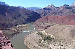 The Colorado River seen from the Escalante Route | |
| Location | Grand Canyon National Park, Arizona, United States |
| Use | Hiking |
| Hiking details | |
| Sights | Grand Canyon |
| Hazards | Severe Weather Overexertion Dehydration Flash Flood |
The Escalante Route is a hiking trail on the South Rim of the Grand Canyon National Park, located in the U.S. state of Arizona. It starts near the Tanner Rapids on the Colorado River and follows the river. It also passes by Escalante Creek and ends near the Hance Rapids.
It falls into the lowest maintenance category ("route") of the Grand Canyon trails which means it is essentially unmaintained. There is an unavoidable 30-feet cliff located near the Hance Rapids which need to be climbed. The National Park Service advises to bring a rope for backpacks. There are several other easy, yet avoidable climbing opportunities in 75 Mile Canyon, some of which have been marked by cairns.
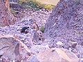
The rock slide located at the end of the Escalante Route
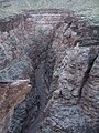
The slot canyon (75-mile Canyon) located along the Escalante Route


See also[edit]
- The Grand Canyon
- List of trails in Grand Canyon National Park
External links[edit]
Escalante Route National Park Service factsheet.
Coordinates: 36°06′14″N 111°50′02″W / 36.104°N 111.834°W / 36.104; -111.834
This Arizona state location article is a stub. You can help Wikipedia by expanding it. |
This United States trail or long-distance path–related article is a stub. You can help Wikipedia by expanding it. |
Categories:
- Hiking trails in Grand Canyon National Park
- Arizona geography stubs
- United States trail stubs
(window.RLQ=window.RLQ||).push(function(){mw.config.set({"wgPageParseReport":{"limitreport":{"cputime":"0.108","walltime":"0.168","ppvisitednodes":{"value":562,"limit":1000000},"ppgeneratednodes":{"value":0,"limit":1500000},"postexpandincludesize":{"value":18134,"limit":2097152},"templateargumentsize":{"value":552,"limit":2097152},"expansiondepth":{"value":10,"limit":40},"expensivefunctioncount":{"value":0,"limit":500},"unstrip-depth":{"value":0,"limit":20},"unstrip-size":{"value":1628,"limit":5000000},"entityaccesscount":{"value":1,"limit":400},"timingprofile":["100.00% 135.070 1 -total"," 48.21% 65.122 1 Template:Infobox_hiking_trail"," 39.18% 52.918 1 Template:Infobox"," 22.57% 30.488 1 Template:Coord"," 9.96% 13.459 2 Template:Comma_separated_entries"," 9.36% 12.649 1 Template:Arizona-geo-stub"," 9.10% 12.290 2 Template:Asbox"," 8.59% 11.607 1 Template:Grand_Canyon_trails"," 6.59% 8.895 1 Template:Navbox"," 4.04% 5.456 3 Template:Convinfobox"]},"scribunto":{"limitreport-timeusage":{"value":"0.041","limit":"10.000"},"limitreport-memusage":{"value":1518474,"limit":52428800}},"cachereport":{"origin":"mw1333","timestamp":"20190203100812","ttl":2073600,"transientcontent":false}}});});{"@context":"https://schema.org","@type":"Article","name":"Escalante Route","url":"https://en.wikipedia.org/wiki/Escalante_Route","sameAs":"http://www.wikidata.org/entity/Q5396817","mainEntity":"http://www.wikidata.org/entity/Q5396817","author":{"@type":"Organization","name":"Contributors to Wikimedia projects"},"publisher":{"@type":"Organization","name":"Wikimedia Foundation, Inc.","logo":{"@type":"ImageObject","url":"https://www.wikimedia.org/static/images/wmf-hor-googpub.png"}},"datePublished":"2007-06-19T01:16:48Z","dateModified":"2013-04-05T04:55:52Z","image":"https://upload.wikimedia.org/wikipedia/commons/1/1a/Overlook_over_the_Colorado.JPG"}(window.RLQ=window.RLQ||).push(function(){mw.config.set({"wgBackendResponseTime":115,"wgHostname":"mw1319"});});


