Pesnica (river)
This article may be expanded with text translated from the corresponding article in Slovenian. (June 2016) Click [show] for important translation instructions.
|
| Pesnica Pößnitz | |
|---|---|
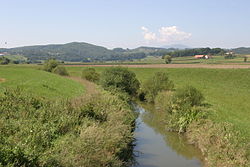 Pesnica near Hrastovec v Slovenskih Goricah | |
| Location | |
| Country | Austria, Slovenia |
| Physical characteristics | |
| Mouth | |
| - location | Drava |
| - coordinates | 46°24′19″N 16°08′14″E / 46.4053°N 16.1371°E / 46.4053; 16.1371Coordinates: 46°24′19″N 16°08′14″E / 46.4053°N 16.1371°E / 46.4053; 16.1371 |
| Length | 69 km (43 mi) [1] |
| Basin size | 550 km2 (210 sq mi) |
| Basin features | |
| Progression | Drava→ Danube→ Black Sea |
The Pesnica (pronounced [ˈpeːsnitsa], German: Pößnitz) is a river in Styria, southeastern Austria and Styria, northeastern Slovenia. It is 69 km long, of which 65 km in Slovenia.[1] Its catchment area is about 550 km2, of which 539 km2 in Slovenia.[1] Its source is near Glanz an der Weinstraße, near the Austrian-Slovenian border. It passes Zgornja Kungota, Pesnica, Pernica, the castle at Hrastovec v Slovenskih Goricah, Lenart v Slovenskih Goricah, the monastery of Sveta Trojica v Slovenskih Goricah, Dornava, and Velika Nedelja, and then merges with the Drava near Ormož, on the border with Croatia.
References
^ abc Rivers, longer than 25 km, and their catchment areas, Statistical Office of the Republic of Slovenia
External links
| Wikimedia Commons has media related to Pesnica (river). |
Condition of Pesnica - graphs, in the following order, of water level, flow and temperature data for the past 30 days (taken in Ranca by ARSO)
Hydrography of Slovenia | ||
|---|---|---|
| Rivers |
|  |
| Streams |
| |
| Waterfalls |
| |
| Lakes |
| |
| Wetlands |
| |
| Sea |
| |
| River valleys |
| |
| Canyons and gorges |
| |
This article related to a river in Slovenia is a stub. You can help Wikipedia by expanding it. |


