Sande, Lower Saxony
| Sande | ||
|---|---|---|
 Water castle | ||
| ||
 Sande Location of Sande within Friesland district 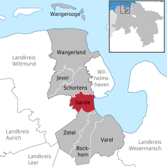  | ||
Coordinates: 53°29′N 8°0′E / 53.483°N 8.000°E / 53.483; 8.000Coordinates: 53°29′N 8°0′E / 53.483°N 8.000°E / 53.483; 8.000 | ||
| Country | Germany | |
| State | Lower Saxony | |
| District | Friesland | |
| Government | ||
| • Mayor | Josef Wesselmann | |
| Area | ||
| • Total | 45 km2 (17 sq mi) | |
| Elevation | 0 m (0 ft) | |
| Population (2017-12-31)[1] | ||
| • Total | 8,862 | |
| • Density | 200/km2 (510/sq mi) | |
| Time zone | CET/CEST (UTC+1/+2) | |
| Postal codes | 26452 | |
| Dialling codes | 0 44 22 | |
| Vehicle registration | FRI | |
| Website | www.sande.de | |

Sande is a municipality in the district of Friesland, Lower Saxony, Germany. It is situated near the Jade Bight, approximately 7 km west of Wilhelmshaven, and 12 km southeast of Jever.
Sande is on the railway which links Oldenburg to Wilhelmshaven and Esens. A bypass is planned so that rail traffic for the JadeWeserPort will not pass through the centre of Sande.[2]
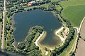
Sander Sea


References
^ Landesamt für Statistik Niedersachsen, Tabelle 12411: Fortschreibung des Bevölkerungsstandes, Stand 31. Dezember 2017
^ "Freight bypass funding agreed - Railway Gazette". Railway Gazette International. Retrieved 9 August 2012..mw-parser-output cite.citation{font-style:inherit}.mw-parser-output q{quotes:"""""""'""'"}.mw-parser-output code.cs1-code{color:inherit;background:inherit;border:inherit;padding:inherit}.mw-parser-output .cs1-lock-free a{background:url("//upload.wikimedia.org/wikipedia/commons/thumb/6/65/Lock-green.svg/9px-Lock-green.svg.png")no-repeat;background-position:right .1em center}.mw-parser-output .cs1-lock-limited a,.mw-parser-output .cs1-lock-registration a{background:url("//upload.wikimedia.org/wikipedia/commons/thumb/d/d6/Lock-gray-alt-2.svg/9px-Lock-gray-alt-2.svg.png")no-repeat;background-position:right .1em center}.mw-parser-output .cs1-lock-subscription a{background:url("//upload.wikimedia.org/wikipedia/commons/thumb/a/aa/Lock-red-alt-2.svg/9px-Lock-red-alt-2.svg.png")no-repeat;background-position:right .1em center}.mw-parser-output .cs1-subscription,.mw-parser-output .cs1-registration{color:#555}.mw-parser-output .cs1-subscription span,.mw-parser-output .cs1-registration span{border-bottom:1px dotted;cursor:help}.mw-parser-output .cs1-hidden-error{display:none;font-size:100%}.mw-parser-output .cs1-visible-error{font-size:100%}.mw-parser-output .cs1-subscription,.mw-parser-output .cs1-registration,.mw-parser-output .cs1-format{font-size:95%}.mw-parser-output .cs1-kern-left,.mw-parser-output .cs1-kern-wl-left{padding-left:0.2em}.mw-parser-output .cs1-kern-right,.mw-parser-output .cs1-kern-wl-right{padding-right:0.2em}
Towns and municipalities in Friesland (district) | ||
|---|---|---|
| ||
Authority control |
|
|---|
This Friesland (district) location article is a stub. You can help Wikipedia by expanding it. |


