Dutywa
Dutywa Idutywa | |
|---|---|
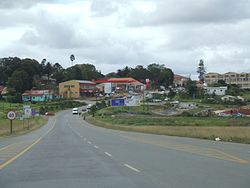
 The N2 about to enter Idutywa | |
 Dutywa Show map of Eastern Cape  Dutywa Dutywa (South Africa) Show map of South Africa  Dutywa Dutywa (Africa) Show map of Africa | |
Coordinates: 32°06′S 28°18′E / 32.100°S 28.300°E / -32.100; 28.300Coordinates: 32°06′S 28°18′E / 32.100°S 28.300°E / -32.100; 28.300 | |
| Country | South Africa |
| Province | Eastern Cape |
| District | Amathole |
| Municipality | Mbhashe |
| Established | 1858 |
| Area[1] | |
| • Total | 20.83 km2 (8.04 sq mi) |
| Population (2011)[1] | |
| • Total | 11,076 |
| • Density | 530/km2 (1,400/sq mi) |
| Racial makeup (2011)[1] | |
| • Black African | 96.6% |
| • Coloured | 1.3% |
| • Indian/Asian | 0.7% |
| • White | 1.1% |
| • Other | 0.4% |
First languages (2011)[1] | |
| • Xhosa | 91.6% |
| • English | 3.3% |
| • Other | 5.1% |
| Time zone | UTC+2 (SAST) |
Postal code (street) | 5000 |
| PO box | 5000 |
| Area code | 047 |
Dutywa (formerly Idutywa)[2] is a town in the Eastern Cape of South Africa, formerly part of the Transkei bantustan. It is the birthplace of Thabo Mbeki, who became President of South Africa in 1999.[3] It is 35 kilometres north of Gcuwa (formerly known as Butterworth) on the N2 road.[4] Dutywa is the seat of the Mbhashe Municipality in the Amatole District.[5]
Dutywa is the economic centre to the people of Willowvale Gatyane, a place where most rural people buy their daily consumption products
History
The town was founded in 1858 as a military fort after a dispute between a Natal Colony raiding party and local people.[6] It is named after the Dutywa River, a tributary of the Mbhashe River.[7] The name means "place of disorder" in the Xhosa language.[6][8] Its spelling was officially changed from "Idutywa" to "Dutywa" on 16 July 2004.[9] The settlement was laid out in 1884 and was made a municipality in 1913.[8]
Xhosa Kingdom
Dutywa is home to the King of AmaXhosa, uKing Mpendulo ka Xolilizwe Sigcawu. Ahh! Zwelonke!. The Xhosa are the second largest cultural group in South Africa, after the Zulu-speaking nation. The Xhosa language (Isixhosa), of which there are variations, is part of the Nguni language group. Xhosa is one of the 11 official languages recognized by the South African Constitution, and in 2006 it was determined that just over 7 million South Africans speak Xhosa as a home language. It is a tonal language, governed by the noun - which dominates the sentence. http://www.sahistory.org.za/article/xhosa. King Zwelonke is the most senior leader of the Xhosa royal family, the leader of the Xhosa Royal Council and overall head of the Tshawe royal clan. Most of the Eastern Cape and parts of the Western Cape used to be the sovereign state of the Xhosa kingdom, with the king as its supreme leader. The sovereignty of the Xhosa kingdom was liquidated after the Ninth Frontier War, which was the last war of dispossession fought between the Xhosas and British colonialists and AmaXhosa resisted with great resilience against the Britons for over 100 years.
Zwelonke is the first Xhosa king to ascend to the throne after the emancipation of South Africa from colonial and apartheid regimes.
He is the founding member of the Forum of Kings, Sultans, Sheiks, Chiefs and Princes of Africa, which was officially launched in Benghazi, Libya in 2008.
[10]
References
^ abcd "Main Place Dutywa". Census 2011..mw-parser-output cite.citation{font-style:inherit}.mw-parser-output q{quotes:"""""""'""'"}.mw-parser-output code.cs1-code{color:inherit;background:inherit;border:inherit;padding:inherit}.mw-parser-output .cs1-lock-free a{background:url("//upload.wikimedia.org/wikipedia/commons/thumb/6/65/Lock-green.svg/9px-Lock-green.svg.png")no-repeat;background-position:right .1em center}.mw-parser-output .cs1-lock-limited a,.mw-parser-output .cs1-lock-registration a{background:url("//upload.wikimedia.org/wikipedia/commons/thumb/d/d6/Lock-gray-alt-2.svg/9px-Lock-gray-alt-2.svg.png")no-repeat;background-position:right .1em center}.mw-parser-output .cs1-lock-subscription a{background:url("//upload.wikimedia.org/wikipedia/commons/thumb/a/aa/Lock-red-alt-2.svg/9px-Lock-red-alt-2.svg.png")no-repeat;background-position:right .1em center}.mw-parser-output .cs1-subscription,.mw-parser-output .cs1-registration{color:#555}.mw-parser-output .cs1-subscription span,.mw-parser-output .cs1-registration span{border-bottom:1px dotted;cursor:help}.mw-parser-output .cs1-hidden-error{display:none;font-size:100%}.mw-parser-output .cs1-visible-error{font-size:100%}.mw-parser-output .cs1-subscription,.mw-parser-output .cs1-registration,.mw-parser-output .cs1-format{font-size:95%}.mw-parser-output .cs1-kern-left,.mw-parser-output .cs1-kern-wl-left{padding-left:0.2em}.mw-parser-output .cs1-kern-right,.mw-parser-output .cs1-kern-wl-right{padding-right:0.2em}
^ Jenkins, Elwyn (2007), Falling into place: the story of modern South African place names, David Philip Publishers, p. 75
^ Encyclopædia Britannica: Thabo Mbeki
^ Pinchuck, Tony (2002). South Africa. Rough Guides. p. 425. ISBN 1-85828-853-3.
^ "Routes Travel Info Portal: Idutywa". Archived from the original on 25 January 2008. Retrieved 30 September 2008.
^ ab Wild Coast Towns: Idutywa Archived 19 August 2008 at the Wayback Machine.
^ Dictionary of Southern African Place Names
^ ab "Idutywa". Routes Travel Info Portal. Archived from the original on 25 January 2008. Retrieved 17 January 2008.
^ Mlambo-Ngcuka, Phumzile (as Minister of Arts and Culture) (16 July 2004). "Approval of official place names". Government Gazette. Pretoria: Government Printer. 26552: 9–11. Archived from the original on 2012-03-13.
^ http://xhosaculture.co.za/the-coronation-of-amaxhosa-king-hm-zwelonke-sigcawu/
| Wikimedia Commons has media related to Dutywa. |
This Eastern Cape location article is a stub. You can help Wikipedia by expanding it. |
