Barwick, Somerset
| Barwick | |
|---|---|
 Barwick Barwick shown within Somerset | |
| Population | 1,221 (2011)[1] |
| OS grid reference | ST564139 |
| District |
|
| Shire county |
|
| Region |
|
| Country | England |
| Sovereign state | United Kingdom |
| Post town | YEOVIL |
| Postcode district | BA22 9 |
| Dialling code | 01935 |
| Police | Avon and Somerset |
| Fire | Devon and Somerset |
| Ambulance | South Western |
| EU Parliament | South West England |
| UK Parliament |
|
Barwick is a village and parish in Somerset, England, situated 2 miles (3.2 km) south of Yeovil in the South Somerset district and on the border with Dorset. The parish, which includes the village of Stoford has a population of 1,221.[1]
Contents
1 History
2 Governance
3 Barwick Park
3.1 Barwick Park follies
4 Transport
5 The church
6 Gallery
7 References
8 External links
History
The earliest signs of habitation in the area were the relics of a Bronze Age burial which were found in 1826, a little to the north of the village of Stoford, which may be a Saxon name derived from Stow-Ford.[2]
Settlement may go back as far as Saxon times, the earliest mention of Barwick being in 1185.
In the Middle Ages, Stoford was shown as a new town and in an Inquisition or survey of 1273 there were 74 burgages each paying 10d (ten pence) a year. The total population of the borough in 1273 was probably over 500. Stoford kept its borough status for at least 300 years. A guildhall was mentioned in 1361 and there is proof of a separate borough court. There was still a 'borough of Stoford' in the musters of 1569.[2]
The parish was part of the hundred of Houndsborough.[3]
Governance
The parish council is responsible for local issues. It sets an annual precept (local rate) to cover the council's operating costs and produces annual accounts for public scrutiny. The parish council evaluates local planning applications and works with the local police, district council officers, and neighbourhood watch groups on matters of crime, security and traffic. The parish council's role also includes initiating projects for the maintenance and repair of parish facilities, as well as consulting with the district council on the maintenance, repair and improvement of highways, drainage, footpaths, public transport and street cleaning. Conservation matters (including trees and listed buildings) and environmental issues are also the responsibility of the council.
The village falls within the non-metropolitan district of South Somerset, which was formed on 1 April 1974 under the Local Government Act 1972, having previously been part of Yeovil Rural District.[4] The district council is responsible for local planning and building control, local roads, council housing, environmental health, markets and fairs, refuse collection and recycling, cemeteries and crematoria, leisure services, parks and tourism.
Somerset County Council is responsible for running the largest and most expensive local services such as education, social services, libraries, main roads, public transport, policing and fire services, trading standards, waste disposal and strategic planning.
It is also part of the Yeovil county constituency represented in the House of Commons of the Parliament of the United Kingdom. It elects one Member of Parliament (MP) by the first past the post system of election, and part of the South West England constituency of the European Parliament which elects seven MEPs using the d'Hondt method of party-list proportional representation.
Barwick Park

John and Grace Newman (Thomas Beach, 1768)
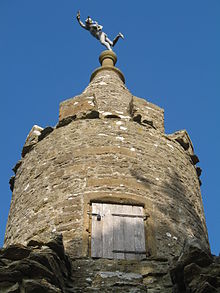
Jack the Treacle Eater, one of the Barwick follies
The estate originally formed part of the property of Syon Abbey, and passed through various hands after the Dissolution in the 1530s.
The present house and park are thought to have been built in 1770 by John and Grace Newman, whose relations owned neighbouring Newton Surmaville.
The house was set in pleasure grounds containing a lake and grotto, while the surrounding parkland was ornamented with a Gothic lodge and a group of four follies. In the early 19th century the estate passed to Thomas Messiter, a barrister, who was John Newman's nephew and in 1830 the mansion was remodelled in a Jacobean Revival style. An orangery was constructed adjoining the north side at the same period.[5] During the early 20th century the estate was let to various persons.
During World War II, it was the location of a prisoner of war camp, initially housing Italian prisoners from the Western Desert Campaign, and later German prisoners after the Battle of Normandy.
Following derequisition of the property, after the war, the Messiter family carried out considerable modernisation and repairs and took up residence. They remained there until some time in the 1960s.
From the late 1960s through to the early 1980s the mansion and surrounding grounds were let to a Major Arthur Grey for use as a privately run approved school taking in difficult teenage boys from inner-city London, Liverpool and several other local authorities around the country. This school was home to T.S. Gryphon, a Sea Cadet unit, with affiliations to H.M.S. Hampshire and nearby H.M.S. Heron.
In the 1990s the estate was sold to a private owner, and substantial repairs were carried out to the house, orangery and landscape structures. The site remains in private ownership.
Barwick Park follies
Barwick Park boasts four follies. Locals say they were built to give the estate labourers work during a time of depression in the 1820s. They were possibly commissioned by George Messiter of Barwick to mark the park boundaries at the four cardinal points: Jack the Treacle Eater (a stone arch topped by a round tower) to the east,[6] the Fish Tower in the north,[7] Messiter's Cone (also known as the Rose Tower), which is 75 feet (23 m) high,[8] at the west[9] end and the Needle to the south.[10] However, paintings of Barwick House in the 1780s, forty years earlier, include two of the follies.
The follies collectively rank on Countryfile's 2009 countdown of "Britain's top 10 follies".[11]
Transport
The parish contains Yeovil Junction railway station, on the London–Exeter line.
The church
The Church of Saint Mary Magdalene is just off the A37 at the western end of the village, about half a mile away from the main centre of population.
The church was built before 1219 as a chapel of the minster church in Yeovil.[12] It has been rebuilt and restored since, particularly in the 1850 when the chancel was rebuilt.[13] There is still a weekly service. The ecclesiastical parish is now part of the benefice of Holy Trinity, Yeovil.
The most architecturally significant features of the church are the bench ends, dating from 1533 - the eve of the English Reformation. The bench ends depict scenes from village life as well as typical pagan symbolism from that period such as the Green Man and the unicorn, a symbol of eternal life. There are also religious objects dating back much earlier, presumably from the church originally on the site, e.g. the Norman font.
The church has been designated by English Heritage as a Grade II* listed building.[14]
Gallery
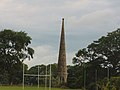
The Cone

Jack the Treacle Eater
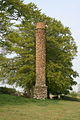
Fish Tower

The Royal Oak in Stoford


References
^ ab "Statistics for Wards, LSOAs and Parishes — SUMMARY Profiles" (Excel). Somerset Intelligence. Retrieved 4 January 2014..mw-parser-output cite.citation{font-style:inherit}.mw-parser-output q{quotes:"""""""'""'"}.mw-parser-output code.cs1-code{color:inherit;background:inherit;border:inherit;padding:inherit}.mw-parser-output .cs1-lock-free a{background:url("//upload.wikimedia.org/wikipedia/commons/thumb/6/65/Lock-green.svg/9px-Lock-green.svg.png")no-repeat;background-position:right .1em center}.mw-parser-output .cs1-lock-limited a,.mw-parser-output .cs1-lock-registration a{background:url("//upload.wikimedia.org/wikipedia/commons/thumb/d/d6/Lock-gray-alt-2.svg/9px-Lock-gray-alt-2.svg.png")no-repeat;background-position:right .1em center}.mw-parser-output .cs1-lock-subscription a{background:url("//upload.wikimedia.org/wikipedia/commons/thumb/a/aa/Lock-red-alt-2.svg/9px-Lock-red-alt-2.svg.png")no-repeat;background-position:right .1em center}.mw-parser-output .cs1-subscription,.mw-parser-output .cs1-registration{color:#555}.mw-parser-output .cs1-subscription span,.mw-parser-output .cs1-registration span{border-bottom:1px dotted;cursor:help}.mw-parser-output .cs1-hidden-error{display:none;font-size:100%}.mw-parser-output .cs1-visible-error{font-size:100%}.mw-parser-output .cs1-subscription,.mw-parser-output .cs1-registration,.mw-parser-output .cs1-format{font-size:95%}.mw-parser-output .cs1-kern-left,.mw-parser-output .cs1-kern-wl-left{padding-left:0.2em}.mw-parser-output .cs1-kern-right,.mw-parser-output .cs1-kern-wl-right{padding-right:0.2em}
^ ab The Somerset Urban Archaeological Survey: Stoford Archived 17 July 2011 at the Wayback Machine., by Miranda Richardson (PDF)
^ "Somerset Hundreds". GENUKI. Retrieved 9 October 2011.
^ "Yeovil RD". A vision of Britain Through Time. University of Portsmouth. Retrieved 4 January 2014.
^ Historic England. "Barwick House and orangery (263563)". Images of England. Retrieved 5 January 2008.
^ Historic England. "Jack the Treacle Eater (263573)". Images of England. Retrieved 5 January 2008.
^ Historic England. "The Fish Tower (263576)". Images of England. Retrieved 5 January 2008.
^ Leete-Hodge, Lornie (1985). Curiosities of Somerset. Bodmin: Bossiney Books. p. 91. ISBN 0-906456-98-3.
^ Historic England. "The Rose Tower (263564)". Images of England. Retrieved 5 January 2008.
^ Historic England. "Needle Obelisk (263562)". Images of England. Retrieved 5 January 2008.
^ http://www.countryfile.com/countryside/britains-top-10-follies
^ Ricjardson, Miranda. "An archaeological assessment of Stoford" (PDF). English Heritage Extensive Urban Survey. Somerset County Council. p. 8. Archived from the original (PDF) on 15 October 2013. Retrieved 15 October 2013.
^ Historic England. "Church of Saint Mary Magdalene (1057217)". National Heritage List for England. Retrieved 15 October 2013.
^ Historic England. "Church of Saint Mary Magdalene (263559)". Images of England. Retrieved 5 January 2008.
External links
![]() Media related to Barwick, Somerset at Wikimedia Commons
Media related to Barwick, Somerset at Wikimedia Commons
Towns, villages and hamlets in the South Somerset district of Somerset, England | ||
|---|---|---|
|  | |


