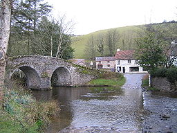
Badgworthy Water
Badgworthy Water
Jump to navigation
Jump to search
| Badgworthy Water | |
| River | |
 The bridge and ford at Malmsmead | |
| Country | England |
|---|---|
| County | Devon |
Tributaries | |
| - left | Hoccombe Water |
| Source | |
| - coordinates | 51°10′38″N 3°43′23″W / 51.17722°N 3.72306°W / 51.17722; -3.72306 |
| Mouth | East Lyn River |
| - coordinates | 51°13′05″N 3°43′42″W / 51.21806°N 3.72833°W / 51.21806; -3.72833Coordinates: 51°13′05″N 3°43′42″W / 51.21806°N 3.72833°W / 51.21806; -3.72833 |
Badgworthy Water is a small river which flows through Malmsmead on Exmoor, close to the border between Devon and Somerset, England.
It merges with Oare Water to become the East Lyn River.[1][2][3]
On the banks of the river are the remains of a few dwellings which formed a medieval village. The last resident left in the 1820s.[4][5]
The 17th century packhorse Malmsmead Bridge crosses Badgworthy Water, alongside an even older ford.[6]
The valley is associated with the book Lorna Doone.[1][7][8]
It has been used for canoeing and includes grade 2 and 3 rapids,[9] walking[10] and fly fishing.[11]
References[edit]
^ ab "Badgworthy Water". Everything Exmoor. Retrieved 2 October 2016..mw-parser-output cite.citation{font-style:inherit}.mw-parser-output q{quotes:"""""""'""'"}.mw-parser-output code.cs1-code{color:inherit;background:inherit;border:inherit;padding:inherit}.mw-parser-output .cs1-lock-free a{background:url("//upload.wikimedia.org/wikipedia/commons/thumb/6/65/Lock-green.svg/9px-Lock-green.svg.png")no-repeat;background-position:right .1em center}.mw-parser-output .cs1-lock-limited a,.mw-parser-output .cs1-lock-registration a{background:url("//upload.wikimedia.org/wikipedia/commons/thumb/d/d6/Lock-gray-alt-2.svg/9px-Lock-gray-alt-2.svg.png")no-repeat;background-position:right .1em center}.mw-parser-output .cs1-lock-subscription a{background:url("//upload.wikimedia.org/wikipedia/commons/thumb/a/aa/Lock-red-alt-2.svg/9px-Lock-red-alt-2.svg.png")no-repeat;background-position:right .1em center}.mw-parser-output .cs1-subscription,.mw-parser-output .cs1-registration{color:#555}.mw-parser-output .cs1-subscription span,.mw-parser-output .cs1-registration span{border-bottom:1px dotted;cursor:help}.mw-parser-output .cs1-hidden-error{display:none;font-size:100%}.mw-parser-output .cs1-visible-error{font-size:100%}.mw-parser-output .cs1-subscription,.mw-parser-output .cs1-registration,.mw-parser-output .cs1-format{font-size:95%}.mw-parser-output .cs1-kern-left,.mw-parser-output .cs1-kern-wl-left{padding-left:0.2em}.mw-parser-output .cs1-kern-right,.mw-parser-output .cs1-kern-wl-right{padding-right:0.2em}
^ "Badgworthy Water — Hoccombe Water to Malmsmead". UK Rivers Guidebook. Retrieved 23 September 2012.
^ "Badgworthy Water". Somerset Rivers. Retrieved 23 September 2012.
^ "MDE1258 - Deserted medieval settlement at Badgworthy Water". Exmoor Historic Environment Record. Exmoor National Park. Retrieved 2 October 2016.
^ "Badgworthy". Beresford's Lost Villages. University of Hull. Retrieved 2 October 2016.
^ "Malmsmead Bridge at NGR SS 7919 4770". Images of England. English Heritage. Retrieved 1 February 2009.
^ "A walk in Lorna Doone country". BBC. Retrieved 2 October 2016.
^ "Walk 1263 - The Doone Valley from Malmsmead". Walking Britain. Retrieved 2 October 2016.
^ "Badgworthy Water - Hoccombe Water to Malmsmead". UK Rivers Guidebook. Retrieved 2 October 2016.
^ "Walk 1263 - The Doone Valley from Malmsmead". Walking Britain. Retrieved 2 October 2016.
^ Hart, Nick. "Bowled over by Badgworthy". Hart Fly Fishing. Retrieved 2 October 2016.
External links[edit]
 Media related to Badgworthy Water at Wikimedia Commons
Categories:
- Rivers of Somerset
- Exmoor
- Lyn catchment
(window.RLQ=window.RLQ||).push(function(){mw.config.set({"wgPageParseReport":{"limitreport":{"cputime":"0.636","walltime":"0.722","ppvisitednodes":{"value":2431,"limit":1000000},"ppgeneratednodes":{"value":0,"limit":1500000},"postexpandincludesize":{"value":76057,"limit":2097152},"templateargumentsize":{"value":21637,"limit":2097152},"expansiondepth":{"value":13,"limit":40},"expensivefunctioncount":{"value":5,"limit":500},"unstrip-depth":{"value":1,"limit":20},"unstrip-size":{"value":27994,"limit":5000000},"entityaccesscount":{"value":1,"limit":400},"timingprofile":["100.00% 650.823 1 -total"," 72.10% 469.275 1 Template:Geobox"," 43.42% 282.590 2 Template:Geobox2_coor"," 42.16% 274.416 2 Template:Country_abbreviation"," 16.70% 108.717 1 Template:Reflist"," 13.76% 89.550 11 Template:Cite_web"," 5.65% 36.790 1 Template:Tfm/dated"," 4.81% 31.337 1 Template:Use_dmy_dates"," 4.66% 30.315 2 Template:Coord"," 2.82% 18.334 2 Template:Navbox"]},"scribunto":{"limitreport-timeusage":{"value":"0.371","limit":"10.000"},"limitreport-memusage":{"value":4035954,"limit":52428800}},"cachereport":{"origin":"mw1239","timestamp":"20181023222857","ttl":1900800,"transientcontent":false}}});mw.config.set({"wgBackendResponseTime":819,"wgHostname":"mw1239"});});