Shire of Serpentine-Jarrahdale
Shire of Serpentine Jarrahdale Western Australia | |||||||||||||||
|---|---|---|---|---|---|---|---|---|---|---|---|---|---|---|---|
 | |||||||||||||||
| Population | 26,833 (2016 census)[1] | ||||||||||||||
| • Density | 29.650/km2 (76.79/sq mi) | ||||||||||||||
| Established | 1894 | ||||||||||||||
| Area | 905 km2 (349.4 sq mi) | ||||||||||||||
| Shire President | Michelle Rich | ||||||||||||||
| Council seat | Mundijong | ||||||||||||||
| Region | Peel region | ||||||||||||||
| State electorate(s) | Darling Range | ||||||||||||||
| Federal Division(s) | Canning | ||||||||||||||
| Website | Shire of Serpentine Jarrahdale | ||||||||||||||
| |||||||||||||||
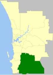
The Shire of Serpentine-Jarrahdale is a local government area in the outer southeastern metropolitan area of Perth, the capital of Western Australia, and has an area of 905 square kilometres (349 sq mi) and a population of almost 27,000 as at the 2016 Census. The Shire's seat of government is the town of Mundijong.
Contents
1 History
2 Wards
3 Suburbs and towns
4 Population
5 References
6 External links
History
The Serpentine Road District was gazetted in December 1894, and in 1913 changed name to Serpentine-Jarrahdale Road District. On 1 July 1961, it became a Shire following the enactment of the Local Government Act 1960. In 1977, it acquired Byford from Shire of Armadale-Kelmscott.[2]
Wards
The Shire was previously split into four wards named: Byford, Central, North West and South. Recently, the boundaries were realigned and on 29 July 2011, the gazetted[3] boundaries became:
- North (4 councillors)
- North West (2 councillors)
- Southern (3 councillors)
Elections to fill all positions in these new wards were called for 15 October 2011.
Suburbs and towns
- Byford
- Cardup
- Darling Downs
- Hopeland
- Jarrahdale
- Karrakup
- Keysbrook
- Mardella
- Mundijong
- Oakford
- Oldbury
- Serpentine
- Whitby
Population
| Year | Population |
|---|---|
| 1911 | 1,454 |
| 1921 | 1,181 |
| 1933 | 1,674 |
| 1947 | 1,709 |
| 1954 | 1,833 |
| 1961 | 1,830 |
| 1966 | 1,728 |
| 1971 | 1,981 |
| 1976 | 3,753 |
| 1981 | 5,039 |
| 1986 | 6,470 |
| 1991 | 8,033 |
| 1996 | 9,749 |
| 2001 | 11,062 |
| 2006 | 12,889 |
| 2011 | 17,746 |
- 1911 populations were: Serpentine RD 328; Jarrahdale RD 1,126.
- The 1976 figure above, reported from the 1978 year book and 1981 census, is the figure after the addition of 1,634 residents living in Byford and nearby areas, which occurred in 1977.
References
^ Australian Bureau of Statistics (27 June 2017). "Serpentine-Jarrahdale (S)". 2016 Census QuickStats. Retrieved 26 November 2017..mw-parser-output cite.citation{font-style:inherit}.mw-parser-output q{quotes:"""""""'""'"}.mw-parser-output code.cs1-code{color:inherit;background:inherit;border:inherit;padding:inherit}.mw-parser-output .cs1-lock-free a{background:url("//upload.wikimedia.org/wikipedia/commons/thumb/6/65/Lock-green.svg/9px-Lock-green.svg.png")no-repeat;background-position:right .1em center}.mw-parser-output .cs1-lock-limited a,.mw-parser-output .cs1-lock-registration a{background:url("//upload.wikimedia.org/wikipedia/commons/thumb/d/d6/Lock-gray-alt-2.svg/9px-Lock-gray-alt-2.svg.png")no-repeat;background-position:right .1em center}.mw-parser-output .cs1-lock-subscription a{background:url("//upload.wikimedia.org/wikipedia/commons/thumb/a/aa/Lock-red-alt-2.svg/9px-Lock-red-alt-2.svg.png")no-repeat;background-position:right .1em center}.mw-parser-output .cs1-subscription,.mw-parser-output .cs1-registration{color:#555}.mw-parser-output .cs1-subscription span,.mw-parser-output .cs1-registration span{border-bottom:1px dotted;cursor:help}.mw-parser-output .cs1-hidden-error{display:none;font-size:100%}.mw-parser-output .cs1-visible-error{font-size:100%}.mw-parser-output .cs1-subscription,.mw-parser-output .cs1-registration,.mw-parser-output .cs1-format{font-size:95%}.mw-parser-output .cs1-kern-left,.mw-parser-output .cs1-kern-wl-left{padding-left:0.2em}.mw-parser-output .cs1-kern-right,.mw-parser-output .cs1-kern-wl-right{padding-right:0.2em}

^ WA Electoral Commission, Municipality Boundary Amendments Register (release 3.0), 31 May 2007.
^ "Serpentine-Jarrahdale Local Government (Serpentine-Jarrahdale - New Wards and Councillor Numbers) Order 2011". 29 July 2011. Retrieved 8 September 2011.
External links
Official website
- ByfordWA: Local community website for the Byford area
Coordinates: 32°17′02″S 115°58′23″E / 32.284°S 115.973°E / -32.284; 115.973


