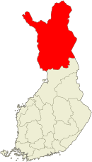
Lapland (Finland)
Lapland Lapin maakunta landskapet Lappland | |||
|---|---|---|---|
| Region | |||
| |||
 | |||
| Coordinates: 67°N 026°E / 67°N 26°E / 67; 26Coordinates: 67°N 026°E / 67°N 26°E / 67; 26 | |||
| Country | Finland | ||
| Capital | Rovaniemi | ||
| Area | |||
| • Total | 100,366 km2 (38,752 sq mi) | ||
| • Land | 92,667 km2 (35,779 sq mi) | ||
| • Water | 7,699 km2 (2,973 sq mi) | ||
| Population (2016-08-31) | |||
| • Total | 179,997 | ||
| • Density | 1.8/km2 (4.6/sq mi) | ||
| Time zone | UTC+2 (EET) | ||
| • Summer (DST) | UTC+3 (EEST) | ||
| ISO 3166 code | FI-10 | ||
| Website | lapinliitto.fi | ||
| Symbols | |||
| Animal | Reindeer | ||
| Bird | Bluethroat | ||
| Fish | Salmon | ||
| Flower | Globe-flower | ||


Lapland (Finnish: Lappi; Northern Sami: Sápmi; Swedish: Lappland, Latin: Lapponia, Russian: Лапландия, Laplandiya) is the largest and northernmost region of Finland. The municipalities in the region cooperate in a Regional Council. Lapland borders the region of North Ostrobothnia in the south. It also borders the Gulf of Bothnia, Norrbotten County in Sweden, Finnmark County and Troms County in Norway, and Murmansk Oblast and the Republic of Karelia in Russia. Lapland's cold and wintry climate, coupled with the relative abundance of conifer trees such as pines and spruces means that it has become associated with Christmas in some countries, most notably the United Kingdom, and holidays to Lapland are common towards the end of the year. Rovaniemi Airport is the third busiest airport in Finland.
The region has been associated with Father Christmas (who is not actually the same as Santa Claus while sharing many characteristics) since 1927, when proposed by Finnish radio host Markus Rautio.[1]
Contents
1 Geography
1.1 Climate
2 History
3 Economy
4 Population
4.1 Regional Council
4.2 Politics
4.3 Sami Domicile Area
4.4 Municipalities
5 Image gallery
6 See also
7 Notes
8 References
9 External links
Geography
The area of Lapland region is 100,367 km², which consists of 92,667 km² of dry land, 6,316 km² fresh water and 1,383 km² of sea areas.[2] In the south it borders Northern Ostrobothnia region, in the west Sweden, in the north and west Norway and in the east Russia. Its borders follow three rivers: Tana, Muonio and Torne. The largest lake is Lake Inari, 1,102 km².[3] Highest point is on Halti, which reaches 1,324 m (4,344 ft) on Finnish side of the border.[4]
The areas of Enontekiö and Utsjoki in northern Lapland are known as Fell-Lapland. The bulk and remaining Lapland is known as Forest-Lapland. Lake Inari, the many fens of the region and the Salla-Saariselkä mountains are all part of Forest-Lapland. Fell-Lapland lies in the fells of the Scandinavian Mountains. Where it is not made up of barren ground like blockfields it has a vegetation of birch forests, willow thickets or heath.[5] Common soil types in Forest-Lapland are till and sand with conifer forest growing on top. These forest show little variation across Lapland. Compared to southern Finland forest tree species grow slower. Understory is typically made of blueberry, lichens, crowberry and ling.[5]
The landscape of large parts of Lapland is an inselberg plain.[6] It has been suggested the inselberg plains formed in Late Cretaceous or Paleogene time by pediplanation or etchplanation.[7] Relative to southern Finland Lapland stand out for its thick till cover.[8][A] The hills and mountains are typically made up of resistant rocks like granite, gneiss, quartzite and amphibolite.[5] The ice sheet that covered Finland intermittently during the Quaternary grew out from the Scandinavian Mountains.[10] The central parts of the Fennoscandian ice sheet had cold-based conditions during the times of maximum extent. This mean that in areas like north-east Sweden and northern Finland pre-existing landforms and deposits escaped glacier erosion and are particularly well preserved at present.[11] Northwest to southeast movement of the ice has left a field of aligned drumlins in central Lapland. Ribbed moraines found in the same area reflect a later west to east change in movement of the ice.[11] During the last deglaciation ice in Lapland retreated from north-east, east and southeast so that the lower course of Tornio was the last part of Finland to be deglaciated 10,100 years ago.[12] Present-day periglacial conditions in Lapland are reflected in the existence of numerous palsas, permafrost landforms developed on peat.[5]
The bedrock of Lapland belong to the Karelian Domain occupying the bulk of the region, the Kola Domain in the northeast around Lake Inari and the Scandinavian Caledonides in the tip of Lapland's northwestern arm. With few exceptions rocks are of Archean and Proterozoic age. Granites, gneiss, metasediments and metavolcanics are common rocks while greenstone belts are recurring features.[13] More rare rock associations include mafic and ultramafic layered intrusions and one of the world's oldest ophiolites.[13][14] The region hosts valuable deposits of gold, chromium, iron and phosphate.[15]
Climate

The Luosto inselberg from air.
The very first snowflakes fall to the ground in late August or early September over the higher peaks. The first ground-covering snow arrives in average in October or late September. Permanent snow cover comes between mid-October and end of November, significantly earlier than in southern Finland. The winter is long, approximately seven months. The snow cover is usually thickest in early April. Soon after that the snow cover starts to melt fast.[16] The thickest snow cover ever was measured in Kilpisjärvi in 19 April 1997 and it was 190 cm.[17] The annual mean temperature varies from a couple of degrees below zero in northwest to a couple of degrees above zero in the southwest (Kemi-Tornio area). Lapland exhibits a trend of increasing precipitation towards the south, with the dryest part being located at the two arms.[18]
History
The area of Lapland was split between two counties of the Swedish Realm from 1634 to 1809. The northern and western areas were part of Västerbotten County, while the southern areas were part of Ostrobothnia County (after 1755 Oulu County). The northern and western areas were transferred in 1809 to Oulu County, which became Oulu Province. Under the royalist constitution of Finland during the first half of 1918, Lapland was to become a Grand Principality and part of the inheritance of the proposed king of Finland. Lapland Province was separated from Oulu Province in 1938.
During the Interim Peace and beginning of the Continuation War the government of Finland allowed the Nazi German Army to station itself in Lapland as a part of Operation Barbarossa. After Finland made a separate peace with the Soviet Union in 1944, the Soviet Union demanded that Finland expel the German army from her soil. The result was the Lapland War, during which almost the whole civilian population of Lapland was evacuated. The Germans used scorched earth tactics in Lapland, before they withdrew to Norway. Forty to forty-seven percent of the dwellings in Lapland and 417 kilometres (259 mi) of railroads were destroyed, 9,500 kilometres (5,900 mi) of roadways were mined, destroyed or were unusable, and 675 bridges and 3,700 kilometres (2,300 mi) of telephone lines were destroyed. Ninety percent of Rovaniemi, the capital of Lapland, was burned to the ground, with only a few pre-war buildings surviving the destruction.
After the Second World War, Petsamo municipality and part of Salla municipality were ceded to the Soviet Union. The decades following the war were a period of rebuilding, industrialization and fast economic growth. Large hydroelectric plants and mines were established and cities, roads and bridges were rebuilt from the destruction of the war. In the late 20th century the economy of Lapland started to decline, mines and factories became unprofitable and the population started to decline rapidly across most of the region.
The provinces of Finland were abolished on January 1, 2010, but Lapland was reorganised as one of the new regions that replaced them.[19]
Economy
| Jobs | 73,300 |
| GDP (million euros) | 5,600 |
| GDP (per capita) | €30,635 (84% Finland average) |
| Private and public offices | 10,400 |
| Private sector revenues (million euros) | 10,000 |
| Exports (million euros) | 3,400 |
| Private and public sector workers | 64,800 |
| Unemployment | 15.3% [21] |
Lapland's economy (2012)
Public sector (33%)
Retail/Lodging/Restaurants (15%)
Industry (14%)
Business services (14%)
Construction (7%)
Traffic and transportation (6%)
Primary production (6%)
Household services (5%)
Population
Lapland is the home of about 3.4% of Finland's population, and is by far the least densely populated area in the country. The biggest towns in Lapland are Rovaniemi (the regional capital), Tornio, and Kemi. In 2011, Lapland had a population of 183,320 of whom 177,950 spoke Finnish, 1,526 spoke Sami, 387 spoke Swedish and 3,467 spoke some other languages as their mother language.[22] Of the Sami languages, Northern Sami, Inari Sami and Skolt Sami are spoken in the region.
Lapland's population has been in decline since 1990.
| Year | Population |
|---|---|
| 1950 | 169,211 |
| 1955 | 189,176 |
| 1960 | 208,788 |
| 1965 | 221,162 |
| 1970 | 197,429 |
| 1975 | 195,131 |
| 1980 | 196,288 |
| 1985 | 200,571 |
| 1990 | 201,652 |
| 1995 | 200,579 |
| 2000 | 189,288 |
| 2005 | 184,935 |
| 2010 | 183,484 |
| 2015 | 180,858 |
Regional Council
The 21 municipalities of Lapland are organised into a single Region, where they cooperate in the Lapland Regional Council, Lapin liitto or Lapplands förbund.
Politics
Lapland has seven seats in the 200-seat parliament of Finland. In Finnish parliamentary election, 2015 four seats went to Centre Party, and True Finns, Left Alliance, and Social Democratic Party got one seat each.[23]
The votes were distributed as follows:
Centre Party 42.9%
True Finns 16.5%
Left Alliance 13.7%
National Coalition Party 10.1%
Social Democratic Party 10.8%
Green League 2.6%
Christian Democrats 1.1%
Swedish People's Party 0.5%
Sami Domicile Area
The northernmost municipalities of Lapland where the Sami people are the most numerous, form the Sami Domicile Area. Sami organization exists in parallel with the provincial one.
Municipalities
The region of Lapland is made up of 21 municipalities, of which four have city status (marked in bold).
| Municipality | Population (2014) | Area (km²) | Density (pop. per km²) | Sub-Region | |
|---|---|---|---|---|---|
Rovaniemi | 61,568 | 8,016.84 | 8.02 | Rovaniemi | |
Tornio | 22,333 | 1,348.85 | 18.84 | Kemi-Tornio | |
Kemi | 21,939 | 747.51 | 232.23 | Kemi-Tornio | |
Sodankylä | 8,825 | 12,415.48 | 0.76 | Northern Lapland | |
Keminmaa | 8,474 | 647.23 | 13.69 | Kemi-Tornio | |
Kemijärvi | 7,889 | 3,930.91 | 2.29 | Eastern Lapland | |
Inari | 6,818 | 17,333.54 | 0.45 | Northern Lapland | |
Kittilä | 6,469 | 8,262.94 | 0.79 | Fell Lapland | |
Ylitornio | 4,454 | 2,212.38 | 2.22 | Torne Valley | |
Ranua | 4,093 | 3,694.80 | 1.21 | Rovaniemi | |
Kolari | 3,842 | 2,617.77 | 1.51 | Fell Lapland | |
Salla | 3,789 | 5,873.08 | 0.68 | Eastern Lapland | |
Pello | 3,674 | 1,863.68 | 2.17 | Torne Valley | |
Posio | 3,636 | 3,544.81 | 1.20 | Eastern Lapland | |
Simo | 3,299 | 2,086.39 | 2.34 | Kemi-Tornio | |
Tervola | 3,238 | 1,592.04 | 2.12 | Kemi-Tornio | |
Muonio | 2,375 | 2,037.80 | 1.25 | Fell Lapland | |
Enontekiö | 1,892 | 8,391.35 | 0.24 | Fell Lapland | |
Utsjoki | 1,259 | 5,372.01 | 0.25 | Northern Lapland | |
Savukoski | 1,100 | 6,495.95 | 0.17 | Eastern Lapland | |
Pelkosenniemi | 949 | 1,881.57 | 0.53 | Eastern Lapland | |
| Total | 181,815 | 100,366.93 | 1.97 |
Image gallery
This section contains what may be an unencyclopedic or excessive gallery of images. (Learn how and when to remove this template message) |

Riisitunturi National Park in Posio, southern Lapland is renowned for its crown snow trees

Saana fell in Enontekiö with Lake Kilpisjärvi in northwesternmost Finland; one of the most recognized landscapes in Finland
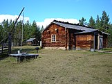
A traditional Lapponian timber house in Siida museum
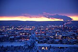
Rovaniemi, the capital of Lapland, during wintertime

Santa Claus Village in Rovaniemi; tourism is crucial to Lapland's economy

Sámi people celebrating Easter

River Tornio near Ylitornio town

Flag of Sámi

Levi, a ski resort in Kittilä

Lapland was burnt down almost totally in World War II (Sodankylä)

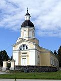
Enontekiö Church, a typical after-World War II-erected church

Reindeer in Enontekiö

Utsjoki Church and church cabins; the northernmost church in Finland

Tornio Town Hall

Wilderness in Enontekiö

A view towards Lake Inari

A general view of Kemi town centre with Gulf of Bothnia in the background

Pallastunturi Fell in Muonio in wintertime twilight
Pielpajärvi Wilderness Church from 1760 managed to avoid getting burnt in World War II

Kemijärvi town centre

A giant's kettle in Salla, one of the largest in the world
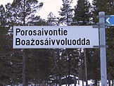
A bilingual (Finnish and Sámi) street sign

A view from Saana fell

Architecture in Kemi
Keminmaa Church

Lake Iso-Vietonen, Ylitornio

River Kevo in Utsjoki

Sami boots in a museum in Rovaniemi

An old gold mine in Inari

Kolari Railway Station, the northernmost in Finland

Pihtsusköngäs Waterfall, Enontekiö

Lappia House in Rovaniemi, a culture venue designed by Alvar Aalto

Ranua Church

Isokuru Canyon, Pelkosenniemi

Traditional North-Osthrobothnian house in Tornio

Lake Peltojärvi in Inari

A view from Haparanda, Sweden to Tornio; the two towns are located so close, divided only by a river, that they're called a twin-town

A view from the annual Snow Castle in Kemi

A Sámi shaman drum mask

A polar bear in Ranua; though in a zoo


See also
- Lappmarken
- Lääni
- Sami people
- Sápmi (area)
- Sea Lapland
Notes
^ Among the glacial deposits of Finnish Lapland pre-Quaternary Cenozoic marine microfossils have been found. These findings were first reported by Astrid Cleve in 1934, leading to the assumption that the areas was drowned by the sea during the Eocene. However, as of 2013, no sedimentary deposit from this time has been found and the marine fossils may have arrived much later by wind transport.[9]
References
^ Geiling, Natasha. "Where Does Santa Live? The North Pole Isn't Always the Answer". smithsonianmag.com. Retrieved 28 March 2018..mw-parser-output cite.citation{font-style:inherit}.mw-parser-output q{quotes:"""""""'""'"}.mw-parser-output code.cs1-code{color:inherit;background:inherit;border:inherit;padding:inherit}.mw-parser-output .cs1-lock-free a{background:url("//upload.wikimedia.org/wikipedia/commons/thumb/6/65/Lock-green.svg/9px-Lock-green.svg.png")no-repeat;background-position:right .1em center}.mw-parser-output .cs1-lock-limited a,.mw-parser-output .cs1-lock-registration a{background:url("//upload.wikimedia.org/wikipedia/commons/thumb/d/d6/Lock-gray-alt-2.svg/9px-Lock-gray-alt-2.svg.png")no-repeat;background-position:right .1em center}.mw-parser-output .cs1-lock-subscription a{background:url("//upload.wikimedia.org/wikipedia/commons/thumb/a/aa/Lock-red-alt-2.svg/9px-Lock-red-alt-2.svg.png")no-repeat;background-position:right .1em center}.mw-parser-output .cs1-subscription,.mw-parser-output .cs1-registration{color:#555}.mw-parser-output .cs1-subscription span,.mw-parser-output .cs1-registration span{border-bottom:1px dotted;cursor:help}.mw-parser-output .cs1-hidden-error{display:none;font-size:100%}.mw-parser-output .cs1-visible-error{font-size:100%}.mw-parser-output .cs1-subscription,.mw-parser-output .cs1-registration,.mw-parser-output .cs1-format{font-size:95%}.mw-parser-output .cs1-kern-left,.mw-parser-output .cs1-kern-wl-left{padding-left:0.2em}.mw-parser-output .cs1-kern-right,.mw-parser-output .cs1-kern-wl-right{padding-right:0.2em}
^ "Suomen pinta-ala kunnittain 1.1.2016" (PDF). National Land Survey of Finland. Retrieved 21 November 2016.
[permanent dead link]
^ "Lake Inari". Encyclopædia Britannica. Retrieved 21 November 2016.
^ "Mount Halti". Encyclopædia Britannica. Retrieved 21 November 2016.
^ abcd Lindberg, Johan (February 2, 2011). "Lappland". Uppslagsverket Finland (in Swedish). Retrieved November 30, 2017.
^ Ebert, K.; Hall, A.; Hättestrand, C.; Alm, G. (2009). "Multi-phase development of a glaciated inselberg landscape". Geomorphology. 115 (1): 56–66.
^ Kaitanen, Veijo (1985). "Problems concerning the origin of inselbergs in Finnish Lapland". Fennia. 163 (2): 359–364.
^ Kleman, J.; Stroeven, A.P.; Lundqvist, Jan (2008). "Patterns of Quaternary ice sheet erosion and deposition in Fennoscandia and a theoretical framework for explanation". Geomorphology. 97 (1–2): 73–90.
^ Hall, Adrian M.; Ebert, Karin (2013). "Cenozoic microfossils in northern Finland: Local reworking or distant wind transport?". Palaeogeography, Palaeoclimatology, Palaeoecology. 388: 1–14. doi:10.1016/j.palaeo.2013.07.012.
^ Fredin, Ola (2002). "Glacial inception and Quaternary mountain glaciations in Fennoscandia". Quaternary International. 95–96: 99–112.
^ ab Sarala, Pertti (2005). "Weichselian stratigraphy, geomorphology and glacial dynamics in southern Finnish Lapland" (PDF). Bulletin of the Geological Society of Finland. 77: 71–104. Archived from the original (PDF) on 2017-12-02. Retrieved December 11, 2017.
^ Stroeven, Arjen P.; Hättestrand, Clas; Kleman, Johan; Heyman, Jakob; Fabel, Derek; Fredin, Ola; Goodfellow, Bradley W.; Harbor, Jonathan M.; Jansen, John D.; Olsen, Lars; Caffee, Marc W.; Fink, David; Lundqvist, Jan; Rosqvist, Gunhild C.; Strömberg, Bo; Jansson, Krister N. (2016). "Deglaciation of Fennoscandia". Quaternary Science Reviews. 147: 91–121.
^ ab Vaasjoki, M.; Korsman, K.; Koistinen, T. (2005). "Overview". In Lehtinen, Martti; Nurmi, Pekka A. Precambrian Geology of Finland. Elsevier Science. pp. 1–17. ISBN 9780080457598.
^ Peltonen, P. (2005). "Ophiolites". In Lehtinen, Martti; Nurmi, Pekka A. Precambrian Geology of Finland. Elsevier Science. pp. 237–277. ISBN 9780080457598.
^ Eilu, P., Ahtola, T., Äikäs, O., Halkoaho, T., Heikura, P., Hulkki, H., Iljina, M., Juopperi, H., Karinen, T., Kärkkäinen, N., Konnunaho, J., Kontinen, A., Kontoniemi, O., Korkiakoski, E., Korsakova, M., Kuivasaari, T., Kyläkoski, M., Makkonen, H., Niiranen, T., Nikander, J., Nykänen, V., Perdahl, J.-A., Pohjolainen, E., Räsänen, J., Sorjonen-Ward, P., Tiainen, M., Tontti, M., Torppa, A. & Västi, K. (2012). "Metallogenic areas in Finland". In Eilu, Pasi. Mineral deposits and metallogeny of Fennoscandia. Geological Survey of Finland, Special Paper. 53. Espoo. pp. 19–32. ISBN 978-952-217-175-7.CS1 maint: Uses authors parameter (link)
^ "Snow statistics". Finnish Meteorological Institute. Retrieved 21 November 2016.
^ "Sääennätyksiä" (in Finnish). Finnish Meteorological Institute. Retrieved 21 November 2016.
^ "Present climate - 30 year mean values". Finnish Meteorological Institute. Retrieved 21 November 2016.
^ "New regional administration model abolishes provinces in 2010". Helsingin Sanomat International Edition. Sanoma Corporation. 31 December 2009. Archived from the original on 23 August 2011. Retrieved 1 January 2010.
^ "Lapin suhdannekatsaus 2013" (PDF). Lapin liitto. 19 August 2013. Archived from the original (PDF) on 24 December 2013. Retrieved 22 December 2013.
^ "Työttömyyden musta siipi varjostaa Lappia". Yle Uutiset. Retrieved 28 March 2018.
^ Statistics Finland – Statistical databases[permanent dead link]
^ "Candidates elected Electoral district of Lapland". vaalit. Elections website of the Ministry of Justice. Retrieved 21 November 2016.
External links
Lapland Regional Council – Official site- House of Lapland
Lapland State Provincial Office – Official site- Lapland Club
 Finnish Lapland travel guide from Wikivoyage
Kemi-Tornio University of Applied Sciences – video portal – Videos about Lapland experiences and lifestyle.
Levi-Lapland – Information on Lapland, the ski resorts and the Lapland Super Pass.- Midnight Sun Film Festival
Former provinces of Finland | ||
|---|---|---|
In parentheses are years when provinces were established and disestablished. | ||
| 1634–1775 |
| |
| 1775–1831 |
| |
| 1831–1918 |
| |
| 1918–1997 |
| |
| 1997–2009 |
| |
Regions of Finland | ||
|---|---|---|
| Regions |
| |
| Former regions |
| |
Authority control |
|
|---|


